Ryde is an English seaside town and civil parish on the north-east coast of the Isle of Wight. The built-up area had a population of 24,096 according to the 2021 Census. Its growth as a seaside resort came after the villages of Upper Ryde and Lower Ryde were merged in the 19th century, as can still be seen in the town's central and seafront architecture. The resort's expansive sands are revealed at low tide. Their width means the regular ferry service to the mainland requires a long listed pier – the fourth longest in the United Kingdom, and the oldest surviving.

Shanklin is a seaside resort town and civil parish on the Isle of Wight, England, located on Sandown Bay. Shanklin is the southernmost of three settlements which occupy the bay, and is close to Lake Sandown. The sandy beach, its Old Village and a wooded ravine, Shanklin Chine, are its main attractions. The esplanade along the beach is occupied by hotels and restaurants for the most part, and is one of the most tourist-oriented parts of the town. The other is the Old Village, at the top of Shanklin Chine. Together with Lake and Sandown to the north, Shanklin forms a built up area of around 25,000 inhabitants, Shanklin alone contributing around 7,200 of this.
Bembridge is a village and civil parish located on the easternmost point of the Isle of Wight. It had a population of 3,848 according to the 2001 census of the United Kingdom, leading to the implausible claim by some residents that Bembridge is the largest village in England. Bembridge is home to many of the Island's wealthiest residents. The population had reduced to 3,688 at the 2011 Census.

Fishbourne is a village between Wootton and Ryde, on the Isle of Wight.

Arreton is a village and civil parish in the central eastern part of the Isle of Wight, England. It is about 3 miles south east of Newport.

St Helens is a village and civil parish located on the eastern side of the Isle of Wight.

Carisbrooke is a village on the south-western outskirts of Newport, in the civil parish of Newport and Carisbrooke, Isle of Wight, England. It is best known as the site of Carisbrooke Castle. It also has a medieval parish church, St Mary's Church, which began as part of a Benedictine priory established by French monks c. 1150. The priory was dissolved by King Henry V of England in 1415, during the Hundred Years' War. In 1907, the church was restored. It has a 14th-century tower rising in five stages with a turret at one corner and a battlemented and pinnacled crown.

Whitwell is a small village and former civil parish, now in the parish of Niton and Whitwell, on the south of the Isle of Wight, England, approximately 5 kilometres north-west of Ventnor, the village's nearest town. In addition to this, it is about five minutes away from its neighbouring small villages of Godshill and Niton. According to 2001 census data, the total population of the village was 578. There is a variety of stone and thatched housing, as well as some more modern housing, the most recent of which was completed in 2006.

Shalfleet is a village and civil parish on the Isle of Wight. it is located between Yarmouth and Newport in the northwest of the island.

Brook is a village and former civil parish, now in the parish of Brighstone, on the Isle of Wight, England. In 1931 the parish had a population of 156. On 1 April 1933 the parish was abolished and merged with Brighstone.
Newchurch is a village and civil parish on the Isle of Wight. It is located between Sandown and Newport in the southeast of the island. Anthony Dillington, owner of the Knighton Gorges Manor in Newchurch wrote to his son Robert in 1574 that, "This is the very Garden of England, and we be privileged to work in it as Husbandmen......." Newchurch obtained its name from the new church built in 1087 by the Norman monks of Lyra. The Newchurch Parish for many centuries stretched from the north to south coasts of the Island; by the early Nineteenth Century the growing resort towns of Ventnor and Ryde were included within its boundaries. The parish was administered by the Church Parish Vestry until 1894 when civil matters were passed to the newly formed Parish Council which now forms the second tier of Local Government under the Isle of Wight Council. In 1982 Alverstone was included in the civil parish. The present day parish includes Newchurch Village, Apse Heath, Winford, Whiteley Bank, Alverstone, Alverstone Garden Village, Queen's Bower, Princelett and Mersley.

Chale is a village and civil parish on the Isle of Wight of England, in the United Kingdom. It is located three kilometres from Niton in the south of the Island in the area known as the Back of the Wight. The village of Chale lies at the foot of St. Catherine's Down.
Havenstreet is a village on the Isle of Wight, located about 2 miles southwest of Ryde, in the civil parish of Havenstreet and Ashey.

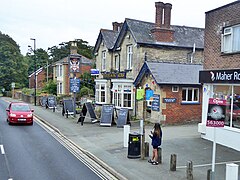
Nettlestone is a village on the Isle of Wight, England about 4 miles (6 km) south east from Ryde. It is recorded in the Domesday Book as in existence in 1066. Together with Seaview, it forms the civil parish of Nettlestone and Seaview.

Bonchurch is a small village in the civil parish of Ventnor, to the east of the town of Ventnor, now largely connected to the latter by suburban development, on the southern part of the Isle of Wight, England. One of the oldest settlements on the Isle of Wight, it is situated on The Undercliff adjacent to the Bonchurch Landslips Site of Special Scientific Interest. The main village is backed by a cliff to the north, with the Upper Bonchurch section on the clifftop halfway up St Boniface Down on the main A3055 road.

Yaverland is a village and former civil parish, now in the parish of Sandown, on the Isle of Wight, England. It is just north of Sandown on Sandown Bay. It has about 200 houses. About 1⁄3 of a mile away from the village is the Yaverland Manor and Church. Holotype fossils have been discovered here of Yaverlandia and a pterosaur, Caulkicephalus. The White Air extreme sports festival was held annually at Yaverland pay and display car park between 1997 and 2008, but moved to Brighton for 2009.
Nettlestone and Seaview is a civil parish and electoral ward on the Isle of Wight. It contains the villages of Nettlestone and Seaview.

Apse Heath is a hamlet on the Isle of Wight, UK. Apse Heath is centered on the intersection of Newport Road and Alverstone Road. At the 2011 Census the Post Office said the population of the hamlet was included in the civil parish of Newchurch, Isle of Wight. It is northeast of Whiteley Bank and south of Winford. Apse Heath is bordered by the leafy villages of Alverstone and Queen's Bower, and is surrounded by areas of woodland and agricultural land. It also sits roughly 2 miles east of the village of Newchurch, and 1 mile west of Lake.

Haylands is an area just to the south of Ryde on the Isle of Wight, off the south coast of England. At the time of the 2011 Census the population etc. of Haylands is listed under Ryde. Located to the east, it is a short walk away from housing estates at Pell and Binstead. The settlement consists mainly of a housing development, including some ex-local authority housing, a corner shop in Upton Road, a primary and a middle school. It is not far from Ryde High School at Pell Lane. In the centre of Haylands there is a pub called Lake Huron. The pub's name originates from the Lake family, a 19th-century family of brewers who owned several pubs naming them after the Great Lakes of North America, Lake Huron is the only one to have survived. Haylands forms part of the local electoral ward of Havenstreet, Ashey and Haylands and at the Isle of Wight Council election in 2009 elected Independent councillor Vanessa Churchman. The settlement lies to the west of the A3055 road. Haylands is approximately 5.5 miles (8.9 km) north-east of Newport. Southern Vectis route 4 used to link the area with Ryde and East Cowes. However this caused the journey time to increase significantly and the area was later withdrawn from the service and after negotiations a limited replacement service was put in place. This service was later improved and is now run as route 37.