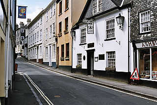
Ashburton is a town on the south-southeastern edge of Dartmoor in Devon, England, adjacent to the A38. The town is 20 miles (32 km) northeast of Plymouth and 17 miles (27 km) southwest of Exeter.

Longnor is a village in the Staffordshire Peak District, England. The settlement dates from early times, the first recorded church building being in the Middle Ages. The village was named Longenalre in the Domesday Book. Located on a major crossroads, Longnor was a significant market town in the 18th century. It lies on the north bank of the River Manifold, on a limestone ridge between the Manifold and the River Dove.
Binstead is a village on the Isle of Wight. It is located in the northeast part of the Island, 1+1⁄2 miles (2.4 km) west of Ryde on the main road A3054 between Ryde and Newport. In the 2011 Census Binstead had been incorporated within Ryde whilst still retaining its electoral ward, Binsted and Fishbourne.

Brailsford is a small red-brick village and civil parish in Derbyshire on the A52 midway between Derby and Ashbourne. The parish also includes Brailsford Green. The civil parish population at the 2011 Census was 1,118. The village has a pub, a golf club, a post office and a school. There are many fine houses in the district including two 20th-century country houses: Brailsford Hall built in 1905 in Jacobean style, and Culland Hall.

Apse Heath is a hamlet on the Isle of Wight, UK. Apse Heath is centered on the intersection of Newport Road and Alverstone Road. At the 2011 Census the Post Office said the population of the hamlet was included in the civil parish of Newchurch, Isle of Wight. It is northeast of Whiteley Bank and south of Winford. Apse Heath is bordered by the leafy villages of Alverstone and Queen's Bower, and is surrounded by areas of woodland and agricultural land. It also sits roughly 2 miles east of the village of Newchurch, and 1 mile west of Lake.

Owston Ferry is a village and civil parish in North Lincolnshire, England. It is situated on the west bank of the River Trent, and 9 miles (14 km) north from Gainsborough. It had a total resident population of 1,128 in 2001 including Kelfield. This increased to 1,328 at the 2011 census. Sometimes referred to as Owston or Ferry, the village forms part of the Isle of Axholme. It is bounded to the west by the A161 road and the village of Haxey. The River Trent is directly to the east. To the north, beyond a number of hamlets and villages, lies the River Humber. West Butterwick was originally a part of the township of Owston.
Mersley is a farming hamlet on the Isle of Wight. Mersley is in Newchurch Parish, and is adjacent to the village of Newchurch itself. Mersley is home to a large garlic farm which is part of the Isle of Wight Garlic Festival in nearby Newchurch, held annually since 1983 and now drawing 25,000 visitors a year. This garlic farm has also been investigated for inappropriate pesticide use in the past.

Borthwood is a hamlet on the Isle of Wight, adjacent to Borthwood Copse, the National Trust woodland. Borthwood includes some holiday cottages and a pet kennel. At the 2011 Census the Post Office specified that the population of the hamlet was included in the civil parish of Newchurch, Isle of Wight.
Puckaster is a hamlet on the Isle of Wight, England. Puckaster is on the southern coast of the Isle of Wight, south of Niton, between St. Catherine's Point and Binnel.

Bierley is a hamlet on the Isle of Wight, UK. Bierley is in the south of the Isle of Wight, north of Niton and 0.7 miles to the west of Whitwell. Bierley is at the corner of Kingates Lane and Newport Road.
Hale Common is a farming hamlet on the Isle of Wight. Hale Common is on the A3056 road between Lake and Arreton. Hale Common is northeast of Bathingbourne and northwest of Branstone. It is in the civil parish of Godshill.
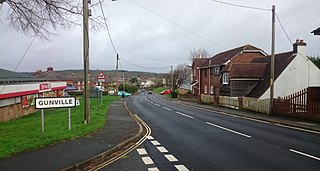
Gunville is a small settlement on the Isle of Wight, off the south coast of England. It largely comprises housing, although there are also a small number of shops, a couple of charity shops, some retail warehouses, a snooker hall, Methodist Church and a fishing lake. The settlement seems to date from some time after 1800, although the vast majority of the buildings currently standing in Gunville date from after 1900.
Fulstow is a marsh village and civil parish in the East Lindsey district of Lincolnshire, England. It is situated 6 miles (10 km) north of Louth and 8 miles (13 km) south of Grimsby.

All Saints' Church, Freshwater is a parish church in the Church of England located in Freshwater, Isle of Wight.

Rev. George Cosens (1805–1881) is the "first reported West Indian minister to hold a pastorate in Britain." He originated from Jamaica, and lived most of his life in Britain having moved to London to study and joining the Primitive Methodists in his late teens. After working as a Primitive Methodist preacher, he joined the Baptists and from 1837 served as a minister in various Baptist churches. He died in working retirement in 1881. George Cosens married twice, Mary Burnet, 1830, and being widowed, Betsy Dancer in 1841. He is buried in the cemetery of Brierley Hill Baptist Church.
Barnes Healing Church is a Christian Spiritualist church on White Hart Lane in Barnes in Richmond upon Thames, London. It holds services on Sunday evenings with a guest medium and also a Wednesday evening session of clairvoyance.

East Lound is a hamlet in the civil parish of Haxey in North Lincolnshire, England. It is situated approximately 22 miles (35 km) to the north-west from the city and county town of Lincoln, and on Brackenhill Road within the parish of Haxey, a village less than 1 mile (1.6 km) to the west. Owston Ferry on the River Trent is 1.5 miles (2.4 km) to the east. East Lound forms part of the Isle of Axholme.

Culm Davy is a historic manor and present-day hamlet within the parish of Hemyock in Devon.
