Birtley, Tyne and Wear

Last updated

Birtley
Durham Road, Birtley - geograph.org.uk - 3781750.jpg
Durham Road, Birtley
Tyne and Wear UK location map.svg
Red pog.svg
Birtley
Location within Tyne and Wear
Population8,367 (2011.Ward)
OS grid reference NZ271563
Metropolitan borough
Metropolitan county
Region
Country England
Sovereign state United Kingdom
Post town Chester Le Street
Postcode district DH2, DH3
Dialling code 0191
Police Northumbria
Fire Tyne and Wear
Ambulance North East
UK Parliament
List of places
UK
England
Tyne and Wear
54°54′00″N1°34′37″W / 54.900°N 1.577°W / 54.900; -1.577
St John the Evangelist church, Birtley St John The Evangelist Church, Birtley - geograph.org.uk - 613593.jpg
St John the Evangelist church, Birtley

Birtley is a town in the Metropolitan Borough of Gateshead, in Tyne and Wear, England. It is situated to the south of Gateshead and is conjoined to Chester-le-Street across the county boundary in County Durham.

Contents

Until 1974, Birtley and the adjoining areas of Barley Mow, Vigo and Portobello were part of Chester-le-Street Rural District under County Durham until being moved into Tyne and Wear under the Borough of Gateshead. It forms an urban area with nearby Chester-le-Street, Washington, Houghton le Spring, Hetton le Hole and Sunderland as part of Wearside. Birtley was a civil parish with a parish council (which also covered the adjoining neighbourhoods) until 1 April 2006, after a local referendum agreed to abolish it. [1] The former parish had a population of 11,377 in 2001. [2] The ward of Birtley in the Gateshead MBC had a population of 8,367 in the 2011 Census. [3]

Elisabethville

Elisabethville was a sovereign Belgian area of Birtley housing Belgian refugees, who worked at the Royal Ordnance Factory during World War I. [4] It was a community of 6000 residents who were accommodated in a mixture of hostels and cottages. [5] When the war ended and the inhabitants were largely repatriated, it was occupied by people of British and other nationalities [4] before its demolition and replacement with more permanent housing. Its history is told in the book The Birtley Belgians .

Angel of the North

Angel of the North Fly-Angel.jpg
Angel of the North

Antony Gormley's famous Angel of the North sculpture, completed in February 1998, is on high ground at the site of the baths of the old 'Betty Ann Pit' at Eighton Lodge, Gateshead, to the north of Birtley.

Religion

There are altogether three mainstream churches in Birtley, which also has a large cemetery with a chapel [6] and crematorium: Birtley is also home to three Jehovah's Witness congregations.

  1. St Joseph's (Roman Catholic) [7] (Built in 1843 after the Roman Catholic Relief Act 1791 and designed by John Dobson in early Gothic style, it is currently served by Fr Martin Wheaton and Deacon Peter Lavery.)
  2. St John the Evangelist (Church of England) [8]
  3. Birtley Methodist Church [9]
  4. Kingdom hall of Jehovahs witnesses shared by three congregations. Birtley, Washington and Chester Le Street.
Remains of Birtley Station in 1965 Birtley 2 Station geograph-2228937-by-Ben-Brooksbank.jpg
Remains of Birtley Station in 1965

The main road through Birtley is the non-primary A167, which runs from Topcliffe, North Yorkshire through to the north of Newcastle upon Tyne and is the same road which runs across the Tyne Bridge. This was an original route for the Great North Road and the A1 until a bypass was built (which was upgraded to motorway standard in the 1960s).

The main East Coast railway line runs to the west of the town. Mainline trains used to stop at the town's long dismantled station. Birtley railway station was closed on 5 December 1955. The Station Hotel was closed in 1971, having been opened in 1868 or earlier.

Related Research Articles

<span class="mw-page-title-main">Gateshead</span> Town in Tyne and Wear, England

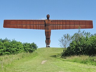
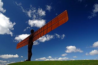
Gateshead is a town in the Gateshead Metropolitan Borough of Tyne and Wear, England. It is on the River Tyne's southern bank. The town's attractions include the twenty metre tall Angel of the North sculpture on the town's southern outskirts, The Glasshouse International Centre for Music and the Baltic Centre for Contemporary Art. The town shares the Millennium Bridge, Tyne Bridge and multiple other bridges with Newcastle upon Tyne.

<span class="mw-page-title-main">Chester-le-Street</span> Town in County Durham, England

Chester-le-Street, is a market town on Wearside in the County Durham district, in the ceremonial county of Durham, England. It is located around 6 miles north of Durham and is also close to Sunderland and Newcastle upon Tyne. It is sited on the River Wear, which runs out to sea at Sunderland to the east. The town holds markets on Tuesdays, Fridays and Saturdays. In 2011, it had a population of 24,227.

<span class="mw-page-title-main">Metropolitan Borough of Gateshead</span> Metropolitan borough in Tyne and Wear, England

The Metropolitan Borough of Gateshead is a metropolitan borough in the metropolitan county of Tyne and Wear, North East England. It includes Gateshead, Rowlands Gill, Whickham, Blaydon, Ryton, Felling, Birtley, Pelaw, Dunston and Low Fell. The borough forms part of the Tyneside conurbation, centred on Newcastle upon Tyne.

<span class="mw-page-title-main">Chester-le-Street (district)</span>

<span class="mw-page-title-main">Blaydon</span> Human settlement in England

Blaydon is a town in the Metropolitan Borough of Gateshead, Tyne and Wear, England, and historically in County Durham. Blaydon, and neighbouring Winlaton, which Blaydon is now contiguous with, form the town of Blaydon-on-Tyne. The Blaydon/Winlaton ward had a population in 2011 was 13,896.

<span class="mw-page-title-main">Blaydon (UK Parliament constituency)</span> Parliamentary constituency in the United Kingdom since 1918

Blaydon is a constituency represented in the House of Commons since 2017 by Liz Twist of the Labour Party.

<span class="mw-page-title-main">Ouston, County Durham</span>

Crawcrook is a semi-rural village close to the western border of the metropolitan county of Tyne and Wear in England. Traditionally an independent village in County Durham, it was incorporated into the Metropolitan Borough of Gateshead on 1 April 1974. The population taken at the 2011 Census of the Gateshead ward had increased to 8,841.

<span class="mw-page-title-main">Lamesley</span> Human settlement in England

Lamesley is a village and civil parish in the Metropolitan Borough of Gateshead, Tyne and Wear, England. The population of the civil parish at the 2011 census was 3,742. The village is on the southern outskirts of Gateshead, near to Birtley. The parish includes Kibblesworth, Lamesley village, Eighton Banks and Northside, Birtley which is predominantly private housing in neighbourhoods named The Hollys, Long Bank, Northdene and Crathie. The ruined Ravensworth Castle is also in Lamesley.

Chester-le-Street was a rural district in County Durham, England from 1894 to 1974. It surrounded the urban district of Chester-le-Street.

<span class="mw-page-title-main">Deckham</span> Human settlement in England

Deckham is a residential suburb in the Metropolitan Borough of Gateshead in Tyne and Wear, England. It is bordered by Gateshead town centre to the north, Sheriff Hill to the south, Felling and Carr Hill to the east and Shipcote to the west. It lies on the B1296, the route of the old Great North Road, 1 mile (1.6 km) south of Gateshead town centre, 1.5 miles (2.4 km) south of Newcastle-upon-Tyne and 13 miles (21 km) north of the city of Durham. In 2011, Deckham had a population of 9,938.

<span class="mw-page-title-main">Kibblesworth</span> Human settlement in England

Kibblesworth is a village 2 miles (3.2 km) west of Birtley, Tyne and Wear, England. Kibblesworth was a mainly rural community until the development of the pit and brickworks and the resulting increase in population. Following the closure of the pit in 1974, few of the residents now work in the village. Historically in County Durham, it was transferred into the newly created county of Tyne and Wear in 1974.

<span class="mw-page-title-main">Chester-le-Street (UK Parliament constituency)</span> Parliamentary constituency in the United Kingdom, 1885–1983

Chester-le-Street was a county constituency centred on the town of Chester-le-Street in County Durham. It returned one Member of Parliament (MP) to the House of Commons of the Parliament of the United Kingdom from 1885 to 1983.

<span class="mw-page-title-main">Lobley Hill</span>

Lobley Hill is located in the west of the old County Borough of Gateshead within the Metropolitan Borough of Gateshead in Tyne and Wear, North East England having been previously part of the parish of Whickham.

<span class="mw-page-title-main">Cade's Road</span> Roman road that ran from the Humber to Newcastle, England

<span class="mw-page-title-main">Concangis</span> Roman fort in Duram, England

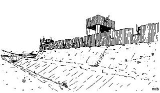
Concangis was an auxiliary castra in the Roman province of Lower Britain. Its ruins are located in Chester-le-Street, Durham, in England, and are now known as Chester-le-Street Roman Fort. It is situated 6 miles (10 km) north of Durham and 8 miles (13 km) south of Newcastle upon Tyne.

<span class="mw-page-title-main">Windy Nook</span> Human settlement in England

Windy Nook is an area in Tyne and Wear, England, bordered by Carr Hill to the west, Whitehills Estate and Leam Lane Estate to the east, Felling to the north and Sheriff Hill to the south. It lies on steep, sloping land 2.25 miles (3.62 km) south of Gateshead, 2.75 miles (4.43 km) south of Newcastle upon Tyne and 12 miles (19 km) north of Durham. In 2011, the Windy Nook and Whitehills ward had a population of 9,781. Formerly part of Heworth, it was incorporated into the newly formed Metropolitan Borough of Gateshead on 1 April 1974.

<span class="mw-page-title-main">Harraton</span> District in Tyne & Wear, England

Harraton is a suburb of Washington, in the City of Sunderland metropolitan borough, in Tyne and Wear, England. Harraton is near the River Wear and is 3 miles north-east of Chester-le-Street, 2 miles south-west of Washington town centre and 9 miles south-southwest of Sunderland.

The county of Durham has returned 7 MPs to the UK Parliament since 1983. Under the Local Government Act 1972, which came into effect on 1 April 1974, the boundaries of the historic/administrative county were significantly altered with the north-east of the county, comprising more than half the electorate, being transferred to the new metropolitan county of Tyne and Wear. In addition, the borough of Hartlepool was included in the new county of Cleveland. These changes were reflected in the following redistribution of parliamentary seats which did not come into effect until the 1983 general election, resulting in a reduction in the county's representation from 16 to 7 MPs.

The ceremonial county of Tyne and Wear has returned 12 MPs to the UK Parliament since 2010. It was created under the Local Government Act 1972, which came into effect on 1 April 1974, comprising the urban areas around the mouths of the Rivers Tyne and Wear, previously parts of the historic counties of Northumberland and Durham.

References

  1. "Town council abolition welcomed". BBC News. 30 June 2005.
  2. "Census 2001 : Parish Headcounts : Gateshead". Office for National Statistics. Retrieved 14 September 2009.
  3. "Gateshead MBC ward population 2011". Office for National Statistics. Archived from the original on 13 July 2015. Retrieved 4 July 2015.
  4. 1 2 Winterman, Denise (15 September 2014). "World War I: How 250,000 Belgium refugees didn't leave a trace". BBC News.
  5. Hodgson, Barbara (12 August 2014). "As First World War commemorations begin Birtley Belgians are remembered". The Journal.
  6. "Birtley Cemetery".
  7. "St Joseph's Roman Catholic Church". Archived from the original on 15 December 2018. Retrieved 1 January 2019.
  8. St. John the Evangelist Church
  9. "Birtley Methodist Church". Archived from the original on 10 September 2011..