The town of Gateshead was an ancient borough, having been granted a charter in 1164 from Hugh Pudsey, the Bishop of Durham.[2] The borough's functions were relatively limited until 1836, when it was made a municipal borough under the Municipal Corporations Act 1835, which standardised how most boroughs operated across the country.[3][4] When elected county councils were created in 1889, Gateshead was considered large enough to provide its own county-level services, and so it was made a county borough, independent from the new Durham County Council.[5]
The modern borough of Gateshead was created on 1 April 1974 under the Local Government Act 1972, as one of five metropolitan boroughs within the new county of Tyne and Wear. The borough covered the whole area of five former districts and part of a sixth, which were all abolished at the same time:[6][7]
Aside from Gateshead, the other districts had all been lower-tier district authorities subordinate to Durham County Council prior to the 1974 reforms. Whilst administratively independent from Durham County Council, the county borough of Gateshead had been part of County Durham for the ceremonial purposes of lieutenancy and shrievalty.[8]
From 1974 until 1986 the borough council was a lower-tier district authority, with Tyne and Wear County Council providing county-level services. The county council was abolished in 1986, since when the borough council has provided both district-level and county-level services, as the old county borough of Gateshead had done prior to 1974. Some functions are provided across Tyne and Wear by joint committees with the other districts. The county of Tyne and Wear continues to exist as a ceremonial county for the purposes of lieutenancy, but has had no administrative functions since 1986.[9]
There is one civil parish in the borough at Lamesley, which forms an additional tier of local government for its area; the rest of the borough is an unparished area.[14] Birtley was also a civil parish with a town council until it was abolished in 2006.[15]
Political control
The council has been under Labour majority control since the modern borough's creation in 1974.[16]
The role of mayor is largely ceremonial in Gateshead. Political leadership is instead provided by the leader of the council. The leaders since 2002 have been:[17]
Since the last boundary changes in 2004 the council has comprised 66 councillors representing 22 wards, with each ward electing three councillors. Elections are held three years out of every four, with a third of the council (one councillor for each ward) elected each time for a four-year term of office.[20]
Prior to 1987 the council had been based at the Town Hall on West Street, which had been completed in 1870 for the old Gateshead Borough Council.[22]
Parliamentary constituencies
In national government the borough contains two parliamentary constituencies, Gateshead and Blaydon. The Gateshead constituency covers the centre and east of the borough. The MP, first elected in 2010, is Ian Mearns (Labour). The Blaydon constituency covers the west of the borough and Birtley to the south, and has been represented since 2017 by Liz Twist, also for Labour. The Jarrow constituency takes in the very eastern tip of the borough, including Pelaw. It is represented by Kate Osborne (Labour).
Political conferences
Gateshead has hosted two major political conferences. The first of these was Labour's spring conference, ahead of the 2005 general election.[23] The Conservatives also held a conference at the Sage Gateshead in March 2008. The Conservatives do not have any councillors in Gateshead and at the time only had one MP in the whole of the north east region. That conference was seen as an attempt to connect to voters in the area.[24]
Gateshead has a number of schools across the borough at both primary and secondary level. Results are well above average, with a number of outstanding schools.[25] Gateshead has amongst the best primary and secondary schools in the country overall.[26] A range of schools are present in Gateshead, including Jewish, Roman Catholic, Church of England, Methodist, and non-religious state schools. There is one independent school in the borough, Chase school in Whickham.[27] Further independent schools can be found in Newcastle, Sunderland, and Tynedale.
Gateshead has a variety of landscapes, urban and industrial areas include the town itself, Whickham and Blaydon in the west, with more semi-rural and rural locations in the west including Ryton and Rowlands Gill. Overall though, it is a fairly green area with over half of the borough being green belt or countryside.[29] Most of this is located away from built up Tyneside to the south of the borough into Derwentside/Chester-le-Street and to the west into Tynedale.
In total, there are over twenty countryside sites in the borough, from ancient meadows and woodland to local nature reserves.[30]
Notable features of Gateshead's countryside include Ryton Willows, found at Old Ryton Village on the banks of the Tyne at Ryton. Ryton Willows is 43 hectares of locally rare grassland and ponds located near to an affluent village with Georgian and Victorian houses. Because of this it is a Site of Special Scientific Interest.[31][32]
The Derwent Valley, in the south/south west of the borough, offers panoramic views and pleasant walks. It was in the Derwent Valley, near Rowlands Gill, that the Northern Kites Project re-introduced red kites. This was part of a national project to introduce the birds, that were once so commonplace across the country, back into the wild. This scheme has proven to be a success, with birds being spotted across the west of the borough, from Crawcrook to Rowlands Gill itself.[33][34]
The borough also contains one National Trust site, the expansive Gibside estate near Rowlands Gill, containing a stately home and a chapel, parts of its grounds have also been given SSSI status.[35]
Even in the more urban areas of the borough, in Gateshead itself and to the east, efforts have been made to maintain green spaces and wildlife sites. One such project is Bill Quay Community Farm, east of the borough. Offering a rural experience within an urban setting, it provides an important educational tool for local schools.[36]
The 2011 census, stated that the Metropolitan Borough of Gateshead was 67.0% Christian, 0.9% Muslim, 1.5% Jewish, 23.9% were not religious and 5.7% of the population refused to state their religion.[38]
Economy
The area was once dependent on heavy industry such as steel making in the Derwent Valley and coal mining (across the borough). Shipbuilding on the Tyne was also a major source of employment. However, with the decline of these industries, Gateshead has attempted to re-invent itself. Although there are significant areas of deprivation in the borough, particularly in the centre and east, a number of towns and villages in the borough are popular with commuters and professionals who are employed in the service industry and well paid areas of the secondary sector such as engineering (which remains a major source of employment). Such commuter areas include Ryton, Rowlands Gill, Whickham and Low Fell. The borough is host to Tyne Yard, a major rail freight yard serving the North East.
The area is also an important retail hub, with the largest shopping centre in the European Union, and second largest in Europe as a whole, the MetroCentre, situated adjacent to the A1 trunk road. Further retail, and a significant number of engineering companies are located in the Team Valley Trading Estate, which at one time was the largest industrial estate in Europe.[citation needed]
The Shipley Art Gallery, housing outstanding collections of contemporary craft, studio ceramics, paintings and decorative art, is managed by Tyne & Wear Archives & Museums on behalf of Gateshead Council. Gateshead is a library authority and within its Central Library is a large venue facility called the Caedmon Hall.[41]
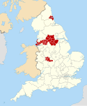
Tyne and Wear is a ceremonial county in North East England. It borders Northumberland to the north and County Durham to the south, and the largest settlement is the city of Newcastle upon Tyne.
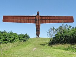
Gateshead is a town in the Gateshead Metropolitan Borough of Tyne and Wear, England. It is on the River Tyne's southern bank. The town's attractions include the twenty metre tall Angel of the North sculpture on the town's southern outskirts, The Glasshouse International Centre for Music and the Baltic Centre for Contemporary Art. The town shares the Millennium Bridge, Tyne Bridge and multiple other bridges with Newcastle upon Tyne.
Blaydon is a constituency represented in the House of Commons since 2017 by Liz Twist of the Labour Party.
Rowlands Gill is a village on the north bank of the River Derwent, in the Metropolitan Borough of Gateshead, Tyne and Wear, England. The Gibside Estate is near the town.
Ryton is a village in Tyne and Wear, England. It is in the Metropolitan Borough of Gateshead, historically part of County Durham. In 2011, the population of the Ryton, Crookhill and Stella ward was 8,146. It is 6 miles (9.7 km) west of Newcastle upon Tyne.
Crawcrook is a village in the Metropolitan Borough of Gateshead in Tyne and Wear, England. The population taken at the 2021 Census of the Gateshead ward was 9,058, increasing from 8,841 in 2011. The village was historically part of County Durham until 1974.
Greenside is a village in the extreme west of the Metropolitan County of Tyne and Wear, England. Once an independent village in County Durham, it became incorporated into Tyne and Wear in 1974 and then the Metropolitan Borough of Gateshead in 1986.
Stella is a community in the Metropolitan Borough of Gateshead, Tyne and Wear, England. It lies on the south bank of the Tyne, about 5 miles (8 km) west of central Newcastle upon Tyne, between Blaydon and Ryton. The area includes the Stella Park housing estate, built on the grounds of a mansion of the same name.
Chester-le-Street was a county constituency centred on the town of Chester-le-Street in County Durham. It returned one Member of Parliament (MP) to the House of Commons of the Parliament of the United Kingdom from 1885 to 1983.
Sunniside is a village in the Metropolitan Borough of Gateshead, which is located around 5.5 miles (9 km) from Newcastle upon Tyne. Prior to the creation of the county of Tyne and Wear in 1974, it was part of Whickham Urban District, which in turn formed a part of County Durham.
The Tyneside Passenger Transport Executive was the operations arm of the Tyneside Passenger Transport Authority, created by the Transport Act 1968. and came into operation on 1 January 1970.
South Tyneside Council is the local authority of for the metropolitan borough of South Tyneside in the ceremonial county of Tyne and Wear in North East England. It is one of five metropolitan boroughs in Tyne and Wear and one of 36 in England. It provides the majority of local government services in South Tyneside. The council has been under Labour majority control since 1979. It is based at South Shields Town Hall. The council is a constituent member of the North East Mayoral Combined Authority.
The 1973 Tyne and Wear County Council election was held on 12 April 1973 as part of the first elections to the new local authorities established by the Local Government Act 1972 in England and Wales. 104 councillors were elected from 95 electoral divisions across the region's five boroughs. Each division returned either one or two county councillors each by First-past-the-post voting for a four-year term of office. The election took place ahead of the elections to the area's metropolitan borough councils, which followed on 10 May 1973.
The county of Durham has returned 7 MPs to the UK Parliament since 1983. Under the Local Government Act 1972, which came into effect on 1 April 1974, the boundaries of the historic/administrative county were significantly altered with the north-east of the county, comprising more than half the electorate, being transferred to the new metropolitan county of Tyne and Wear. In addition, the borough of Hartlepool was included in the new county of Cleveland. These changes were reflected in the following redistribution of parliamentary seats which did not come into effect until the 1983 general election, resulting in a reduction in the county's representation from 16 to 7 MPs.
The ceremonial county of Tyne and Wear has returned 12 MPs to the UK Parliament since 2010. It was created under the Local Government Act 1972, which came into effect on 1 April 1974, comprising the urban areas around the mouths of the Rivers Tyne and Wear, previously parts of the historic counties of Northumberland and Durham.
Blaydon and Consett is a proposed constituency of the House of Commons in the UK Parliament. Further to the completion of the 2023 Periodic Review of Westminster constituencies, it will first be contested at the next general election.
References
↑ The parish of Birtley was also reduced in area as part of the 1974 reforms to exclude the part within the designated area for the new town of Washington, which went to the borough of Sunderland.
This page is based on this Wikipedia article Text is available under the CC BY-SA 4.0 license; additional terms may apply. Images, videos and audio are available under their respective licenses.