County Durham (district)

Last updated

County Durham
Durham
Durham MMB 02 Cathedral.jpg
Seaham Beach - geograph.org.uk - 2842298.jpg
Aerial view of Chester Burn Railway Viaduct, Chester-le-Street.jpg
Barnard Castle - geograph.org.uk - 2482223.jpg
Shildon Locomotion Museum - geograph.org.uk - 4285945.jpg
Flag of Durham County Council.svg
Arms of Durham County Council.svg
County Durham Council UK locator map.svg
Shown within Durham ceremonial county
Sovereign state United Kingdom
Country England
Region North East England
County Durham
Unitary Authority1 April 2009
Seat Durham
Government
  Type Non-metropolitan
Unitary authority
  Local Authority Durham County Council
   MPs Mary Foy (L)
Dehenna Davison (C)
Paul Howell (C)
Grahame Morris (L)
Kevan Jones (L)
Richard Holden (C)
Population
 (2021)
  Total521,346 (Ranked 10th)
Ethnicity (2021)
[1]
   Ethnic groups
List
Religion (2021)
[1]
   Religion
List
Time zone UTC+0 (Greenwich Mean Time)
Postcode
Dialling code 0191
ISO 3166-2 GB-DUR
ONS code 00EJ (ONS)
E06000047 (GSS)
Website durham.gov.uk

County Durham is a local government district in the ceremonial county of County Durham, England. It is governed by Durham County Council, a unitary authority. [2] The district has an area of 2,232.6 km2 (862 sq m), and contains 135 civil parishes. [3] It forms part of the larger ceremonial county of Durham, together with boroughs of Darlington, Hartlepool, and the part of Stockton-on-Tees north of the River Tees.

Contents

History

Between 1974 and 1 April 2009, County Durham was governed as a two-tier non-metropolitan county, with a county council and district councils. The original eight districts were Chester-le-Street, Darlington, Derwentside, Durham (city), Easington, Sedgefield, Teesdale, and Wear Valley. [4] In 1997 Darlington was removed from the non-metropolitan county and became a separate unitary authority. [5] In 2009 the remaining districts were abolished and replaced by a single district covering the non-metropolitan county, with Durham County Council as the sole local authority. [6]

Geography

The district has multiple hamlets and villages. Settlements with town status include Consett, Barnard Castle, Peterlee, Seaham, Bishop Auckland, Newton Aycliffe, Middleton-in-Teesdale, Shildon, Chester-le-Street, Crook, Stanley, Willington, Stanhope, Spennymoor, Ferryhill and Sedgefield while Durham is the only city in the district.[ citation needed ]

Neighbouring council areas
Local authorityIn relation to the district
Northumberland North
Gateshead North east
City of Sunderland North east
Hartlepool South east
Stockton-on-Tees South east
Darlington South
North Yorkshire South
Westmorland and Furness West

Governance

Following the 2021 United Kingdom local elections, the council is now[ when? ] under control of a coalition of the Liberal Democrats, Conservative Party, Independents and North East Party.[ citation needed ]

Education

Durham LEA has a comprehensive school system with 36 state secondary schools (not including sixth form colleges) and five independent schools (four in Durham and one in Barnard Castle). Easington district has the largest school population by year, and Teesdale has the smallest with two schools. Only one school in Easington and Derwentside districts have sixth forms, with about half the schools in the other districts having sixth forms.[ citation needed ]

Notes

    Related Research Articles

    <span class="mw-page-title-main">Counties of England</span> Geographic divisions of England

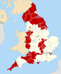
    The counties of England are divisions of England. Counties have been used as administrative areas in England since Anglo-Saxon times. There are two main legal definitions of the counties in modern usage: the 84 counties for the purposes of local government, and the 48 counties for the purposes of lieutenancy, also termed the ceremonial counties.

    <span class="mw-page-title-main">County Durham</span> County of England

    County Durham, officially simply Durham (/ˈdʌrəm/), is a ceremonial county in North East England. The county borders Northumberland and Tyne and Wear to the north, the North Sea to the east, North Yorkshire to the south, and Cumbria to the west. The largest settlement is Darlington.

    <span class="mw-page-title-main">Borough of Stockton-on-Tees</span> Unitary authority area in County Durham, England

    The Borough of Stockton-on-Tees is a unitary authority with borough status in the counties of County Durham and North Yorkshire, England. The borough had a population of 196,600 in 2021.

    <span class="mw-page-title-main">Non-metropolitan county</span> County-level entity in England

    A non-metropolitan county, or colloquially, shire county, is a subdivision of England used for local government.

    <span class="mw-page-title-main">Tees Valley</span> Devolved region in Northern England

    The Tees Valley is a devolved region in Northern England, around the lower River Tees. The area is not a geographical valley; the local term for the valley is Teesdale. The combined authority covers five council areas: Darlington, Hartlepool, Middlesbrough, Redcar and Cleveland and Stockton-on-Tees.

    <span class="mw-page-title-main">Sedgefield (UK Parliament constituency)</span> Parliamentary constituency in the United Kingdom since 1983

    Sedgefield is a constituency in County Durham represented in the House of Commons of the UK Parliament since 2019 by Paul Howell of the Conservative Party. It elects one Member of Parliament (MP) by the first past the post system of election.

    <span class="mw-page-title-main">Bishop Auckland (UK Parliament constituency)</span> UK Parliament constituency in England since 1885

    Bishop Auckland is a constituency in County Durham represented in the House of Commons of the UK Parliament since 2019 by Dehenna Davison, a Conservative.

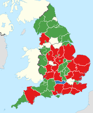
    Durham County Council elections are held every four years. Durham County Council is the local authority for the unitary authority of County Durham. Since becoming a unitary authority, 126 councillors have been elected from 63 wards.

    <span class="mw-page-title-main">Borough of Darlington</span> Unitary authority area in County Durham, England

    The Borough of Darlington is a local government district with borough status in County Durham, England. Since 1997 Darlington Borough Council has been a unitary authority, with both district-level and county-level functions; it is independent from Durham County Council. It is named after its largest settlement, the town of Darlington, where the council is based. The borough also includes a rural area surrounding the town which contains several villages. The population of the borough at the 2021 census was 107,800, of which over 86% (93,015) lived in the built-up area of Darlington itself.

    They had been successive district administration in the County of Durham. The ancient county was formerly structured around the Bishop of Durham with ancient wards and boroughs.

    <span class="mw-page-title-main">Unitary authorities of England</span> Local government in some parts of England

    The unitary authorities of England are a type of local authority responsible for all local government services in an area. They combine the functions of a non-metropolitan county council and a non-metropolitan district council, which elsewhere in England provide two tiers of local government.

    <span class="mw-page-title-main">Cleveland (county)</span> Former county of North East England

    Cleveland was a non-metropolitan county located in North East England which existed between 1974 and 1996. Cleveland was a two-tier county and had four boroughs: Hartlepool, Stockton-on-Tees, Middlesbrough and Langbaurgh-on-Tees. The county town was Middlesbrough, where Cleveland County Council met. The county was named after the historic area of Cleveland, Yorkshire. Its area is now split between the counties of North Yorkshire and County Durham.

    <span class="mw-page-title-main">Durham County Council</span> Local authority in North East England

    Durham County Council is the local authority which governs the non-metropolitan county of County Durham in North East England. Since 2009 it has been a unitary authority, having taken over district-level functions when the county's districts were abolished. The non-metropolitan county is smaller than the ceremonial county of County Durham, which additionally includes Darlington, Hartlepool and the parts of Stockton-on-Tees north of the River Tees. The county council has its headquarters at County Hall in Durham.

    <span class="mw-page-title-main">Healthcare in Durham</span> Healthcare services

    Healthcare in Durham, from 2013 to July 2022, was the responsibility of NHS Durham Dales, Easington and Sedgefield, and Sunderland and South Tyneside clinical commissioning groups. In July 2019 they proposed to merge into two, one covering Durham, and the other covering Tees Valley and including Darlington.

    The county of Durham has returned 7 MPs to the UK Parliament since 1983. Under the Local Government Act 1972, which came into effect on 1 April 1974, the boundaries of the historic/administrative county were significantly altered with the north-east of the county, comprising more than half the electorate, being transferred to the new metropolitan county of Tyne and Wear. In addition, the borough of Hartlepool was included in the new county of Cleveland. These changes were reflected in the following redistribution of parliamentary seats which did not come into effect until the 1983 general election, resulting in a reduction in the county's representation from 16 to 7 MPs.

    References

    1. 1 2 UK Census (2021). "2021 Census Area Profile – Durham Local Authority (E06000047)". Nomis. Office for National Statistics . Retrieved 5 January 2024.
    2. "Durham unitary authority approved". BBC News. 25 July 2007. Retrieved 1 August 2021.
    3. "County Durham". Ordnance Survey . Retrieved 23 May 2021.
    4. "Durham council leader explains the benefits of a becoming large unitary authority". The Northern Echo. 2 March 2021. Retrieved 1 August 2021.
    5. "The Durham (Borough of Darlington) (Structural Change) Order 1995". legislation.gov.uk. Retrieved 18 June 2023.
    6. "The County Durham (Structural Change) Order 2008". legislation.gov.uk. Retrieved 18 June 2023.