Blackburn with Darwen

Last updated

Borough of Blackburn with Darwen
Blackburn Lancashire Townscape.jpg
Entwhistle Bottoms - panoramio.jpg
Belmont - geograph.org.uk - 4869896.jpg
Darwen - Market Hall and Parliament Street - geograph.org.uk - 4188623.jpg
Leeds and Liverpool Canal, Feniscowles - geograph.org.uk - 2519005.jpg
Blackburn with Darwen Borough Council COA.svg
Motto(s): 
Latin: Arte et Labore, lit. 'By Skill and Labour'
Blackburn with Darwen UK locator map.svg
Blackburn with Darwen shown within Lancashire
Coordinates: 53°45′00″N2°28′53″W / 53.7500°N 2.4815°W / 53.7500; -2.4815
Sovereign state United Kingdom
Country England
Region North West
Ceremonial county Lancashire
Incorporated1974
Unitary authority1998
Named for Blackburn and Darwen
Administrative HQ Blackburn Town Hall
Government
[1]
  Type Unitary authority with leader and cabinet
  Body Blackburn with Darwen Borough Council
   Control Labour
  LeaderPhil Riley (L)
   Mayor Parwaiz Akhtar
   Chief Executive Denise Park
   House of Commons
Area
[2]
  Total53 sq mi (137 km2)
  Rank 173rd
Population
 (2021) [3]
  Total154,922
  Rank 135th
  Density2,930/sq mi (1,131/km2)
Ethnicity (2021)
[4]
   Ethnic groups
List
Religion (2021)
[4]
   Religion
List
Time zone UTC+0 (GMT)
  Summer (DST) UTC+1 (BST)
Postcode area
Dialling code 01254
ISO 3166 code GB-BBD
GSS code E06000008
ITL code TLD41
GVA 2021 estimate [5]
 Total £3.4 billion
 Per capita£21,843
GDP (nominal)2021 estimate [5]
 Total£3.9 billion
 Per capita£24,864
Website blackburn.gov.uk

Blackburn with Darwen is a borough and unitary authority area in Lancashire, North West England. It consists of the towns of Blackburn and Darwen but covers a wider area which includes the villages of Lower Darwen, Feniscowles, Brownhill and Hoddlesden. [6]

Contents

Formation

It was founded in 1974 as the Lancashire borough of Blackburn, from the County Borough of Blackburn, the Municipal Borough of Darwen, the parish of North Turton from Turton Urban District (chiefly the villages of Belmont, Chapeltown and Edgworth) and parts of Blackburn Rural District. It was renamed in May 1997, in preparation for a split from Lancashire County Council. On 1 April 1998 it became a unitary authority.

Demographics

Ethnicity

Ethnicity of school pupils [7]
Ethnic groupSchool year
2021/2022
Number%
White: Total12,91146.1
White: British 11,87642.4
White: Irish 280.1
White: Traveller of Irish heritage250.1
White: Gypsy/Roma210.1
White: Other 9613.4
Asian / Asian British: Total12,83545.8
Asian / Asian British: Indian 4,59216.4
Asian / Asian British: Pakistani 7,28226.0
Asian / Asian British: Bangladeshi 2901.0
Asian / Asian British: Chinese 710.3
Asian / Asian British: Other Asians6002.1
Black / Black British: Total3441.2
Black: Caribbean 130.0
Black: African 2741.0
Black: Other Blacks 570.2
Mixed / British Mixed 1,1294
Other: Total4741.7
Unclassified2901.0
Total:27,983100.0

Religion

According to the 2021 census, 38.0% of the population was Christian, 35.0% Muslim, 0.3% Hindu, 0.2% Buddhist, 0.4% followed another religions (including Judaism, Sikhism and others), 21.1% were not affiliated to a religion and 5.0% did not state their religious views.

Religion in Blackburn with Darwen as of 2021 [8]

   Christianity (38.0%)
   Islam (35.0%)
   Hinduism (0.3%)
   Buddhism (0.2%)
   Sikh (0.1%)
   No religion (21.1%)
  Not stated (5.0%)
  Other (0.3%)

Governance

The council is based at Blackburn Town Hall on King William Street in the centre of Blackburn. As a unitary authority, Blackburn with Darwen Borough Council provides most local government services. Parts of the borough are covered by civil parishes, which provide a lower tier of local government.

Economy

This is a chart of trend of regional gross value added of Blackburn with Darwen at current basic prices published Archived 22 August 2006 at the Wayback Machine (pp. 240–253) by Office for National Statistics with figures in millions of British Pounds Sterling.

YearRegional Gross Value Added [lower-alpha 1] Agriculture [lower-alpha 2] Industry [lower-alpha 3] Services [lower-alpha 4]
19951,4963755737
20001,5973678916
20031,78546471,134

Settlements

Civil parishes

Blackburn with Darwen parishes map.svg
  1. Darwen (town council)
  2. Eccleshill
  3. Livesey
  4. North Turton
  5. Pleasington
  6. Tockholes
  7. Yate and Pickup Bank

The town of Blackburn and the village of Hoddlesden lie in unparished areas.

Education

As a unitary authority, Blackburn with Darwen authority has a statutory responsibility for educational standards and schooling within its boundaries. [9]

Transport

Blackburn with Darwen Council has a stated transport policy of "making roads traffic free". [10]

Freedom of the Borough

The following people and military units have received the Freedom of the Borough of Blackburn with Darwen.

Individuals

Military Units

[12]

See also

Notes

  1. Components may not sum to totals due to rounding
  2. includes hunting and forestry
  3. includes energy and construction
  4. includes financial intermediation services indirectly measured

Related Research Articles

<span class="mw-page-title-main">Blackburn</span> Town in Lancashire, England

Blackburn is an industrial town and the administrative centre of the Blackburn with Darwen borough in Lancashire, England. The town is north of the West Pennine Moors on the southern edge of the Ribble Valley, 8 mi (13 km) east of Preston and 21 mi (34 km) north-northwest of Manchester. Blackburn is the core centre of the wider unitary authority area along with the town of Darwen. It is the second largest town in Lancashire.

<span class="mw-page-title-main">Metropolitan Borough of Bolton</span> Borough of Greater Manchester, England

The Metropolitan Borough of Bolton is a metropolitan borough in Greater Manchester, England, named after its largest town, Bolton, but covering a larger area which includes Blackrod, Farnworth, Horwich, Kearsley, Westhoughton, and part of the West Pennine Moors. It had a population of 296,041 in 2021, making it the third-most populous district in Greater Manchester.

<span class="mw-page-title-main">Brownhill</span> Human settlement in England

Brownhill is a suburb of Blackburn, in the unitary borough of Blackburn with Darwen, in Lancashire, England. It is situated to the north-east of the town centre, in the Roe Lee ward which has an estimated population of 5,948. Other nearby places include Ramsgreave, Wilpshire and Sunnybower.

Turton may refer to:

<span class="mw-page-title-main">Belmont, Lancashire</span> Human settlement in England

Belmont is a village and former civil parish, now in the parish of North Turton, in the unitary authority area of Blackburn with Darwen, in the ceremonial county of Lancashire, England. It is close to Darwen and has around 500 inhabitants.

<span class="mw-page-title-main">Feniscowles</span> Human settlement in England

Feniscowles is a village in the unitary authority of Blackburn with Darwen, Lancashire, England. It lies approximately 3 miles (4.8 km) west of Blackburn, in the civil parish of Livesey.

<span class="mw-page-title-main">Tockholes</span> Human settlement in England

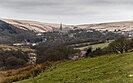
Tockholes is a village and civil parish which forms part of the Blackburn with Darwen unitary authority in the English county of Lancashire, England. Tockholes consists of the village of Tockholes itself and the hamlet of Ryal Fold, and has a population of 454, increasing to 478 at the 2011 Census. It lies on the West Pennine Moors and is surrounded by the towns of Blackburn to the north and Darwen to the east and by the villages of Belmont to the south and Withnell to the west. Darwen Tower is a prominent local landmark that lies to the east of Tockholes and the Roddlesworth Reservoirs and Tockholes forest plantation lie to the south with the M65 passing to the north. There are two churches: Tockholes United Reformed Church and Saint Stephen's Church.

North Turton is a civil parish of the unitary authority of Blackburn with Darwen in Lancashire, England. According to the United Kingdom Census 2001 the civil parish has a population of 3,736, increasing to 3,867 at the 2011 Census. North Turton is the northern part of the historic area of Turton.

<span class="mw-page-title-main">Edgworth</span> Human settlement in England

Edgworth is a small village within the borough of Blackburn with Darwen, Lancashire, England. It is north east of North Turton between Broadhead Brook on the west and Quarlton Brook in the south east. The ground ranges from 650 feet (200 m) to 1,100 feet (340 m) above sea level.

<span class="mw-page-title-main">Chapeltown, Lancashire</span> Human settlement in England

Chapeltown is a village of the civil parish of North Turton, in the Blackburn with Darwen unitary authority, in the north west of England. It is on the B6391 road, on the southern slopes of the West Pennine Moors. The village was once the historic centre of the old Turton Urban District.

<span class="mw-page-title-main">Pleasington</span> Human settlement in England

Pleasington is a village and civil parish in the Borough of Blackburn with Darwen, Lancashire, England. It had a population of 467 in the 2001 census, reducing to 446 at the 2011 census.

<span class="mw-page-title-main">Yate and Pickup Bank</span> Civil parish in Blackburn with Darwen, Lancashire, UK

Yate and Pickup Bank is a civil parish in the borough of Blackburn with Darwen, Lancashire, England. The population of the civil parish taken at the census of 2011 was 366. The parish contains two hamlets, Bank Fold and Pickup Bank and part of the village of Belthorn which is on the boundary with Hyndburn. It has boundaries with the parishes of Eccleshill to the west and North Turton to the south.

Turton is a historical area in the North West of England. It is divided between the ceremonial counties of Lancashire and Greater Manchester. The Turton area is located north of Bolton and south of Blackburn. The area historically formed a township in the ancient parish of Bolton le Moors. The principal village in the township is now known as Chapeltown.

<span class="mw-page-title-main">Entwistle, Lancashire</span> Human settlement in England

Entwistle is a village in the Blackburn with Darwen unitary authority in Lancashire in the north west of England.

<span class="mw-page-title-main">Hoddlesden</span> Human settlement in England

Hoddlesden is a village in the borough of Blackburn with Darwen, in Lancashire, England. The village population at the 2011 census was 1,239. It is in the borough's East Rural ward, and is situated east of Darwen. To the north there are the parishes of Eccleshill and Yate and Pickup Bank, to the east there is Haslingden Grane, part of the West Pennine Moors, and to the south-west there is Blacksnape, a small hamlet.

<span class="mw-page-title-main">Borough of Blackpool</span> Unitary authority area in Lancashire, England

The Borough of Blackpool is a unitary authority area with borough status in the ceremonial county of Lancashire, England. It is named after the seaside town of Blackpool but covers a wider area which includes Anchorsholme, Bispham, Layton, Marton and Squires Gate. As well as the suburbs of Grange Park, North Shore, South Shore and Starr Gate. The borough also forms the core of the wider Blackpool conurbation.

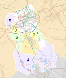
West Pennine is a ward within the borough of Blackburn with Darwen, represented by three borough councillors. It was created in May 2018 when areas of the former wards of North Turton with Tockholes, East Rural, and Whitehall were merged as part of a Boundary Commission review. West Pennine encompasses a number of rural villages, including Belmont, Chapeltown, Edgworth, Hoddlesden, and Eccleshill alongside parts of Whitehall in Darwen. Landmarks include Winter Hill and Turton Tower.

References

  1. "Council and democracy". Blackburn with Darwen Borough Council. Retrieved 22 January 2024.
  2. "Mid-Year Population Estimates, UK, June 2021". Office for National Statistics. 21 December 2022. Retrieved 18 October 2023.
  3. "Mid-Year Population Estimates, UK, June 2021". Office for National Statistics. 21 December 2022. Retrieved 18 October 2023.
  4. 1 2 UK Census (2021). "2021 Census Area Profile – Blackburn with Darwen Local Authority (E06000008)". Nomis. Office for National Statistics . Retrieved 22 January 2024.
  5. 1 2 Fenton, Trevor (25 April 2023). "Regional gross domestic product: local authorities". Office for National Statistics. Retrieved 13 December 2023.
  6. "Unitary Authority population 2011". Archived from the original on 4 March 2016. Retrieved 15 January 2016.
  7. "Schools, pupils and their characteristics, Academic Year 2021/22". explore-education-statistics.service.gov.uk. Retrieved 28 November 2022.
  8. "Religion". Office for National Statistics . Retrieved 7 December 2022.
  9. "Types of Council". Archived from the original on 26 January 2013. Retrieved 6 January 2013.
  10. Blackburn with Darwen Council. "Transport & streets policies & strategies". Archived from the original on 11 June 2017. Retrieved 27 May 2017.
  11. Jacobs, Bill (25 September 2015). "Former Blackburn MP Jack Straw to be given 'freedom' of the borough". The Lancashire Telegraph. Retrieved 17 January 2022.
  12. "Freedom of the Borough". Blackburn with Darwen Borough Council. Retrieved 17 January 2022.

Council political parties