Borough of Wyre

Last updated

Wyre
Looking across the Wyre estuary to Fleetwood - geograph.org.uk - 3139781.jpg
Shopping area, Poulton-le-Fylde - geograph.org.uk - 3314708.jpg
High Street, Garstang - geograph.org.uk - 5067356.jpg
Thorton Cleveleys (7296247012).jpg
Coastal Path, Preesall - geograph.org.uk - 2296471.jpg
Wyre UK locator map.svg
Wyre shown within Lancashire and England
Sovereign state United Kingdom
Constituent country England
Region North West England
Ceremonial county Lancashire
Founded1974
Admin. HQ Poulton-le-Fylde
Government
  TypeWyre Borough Council
   MPs: Paul Maynard, Cat Smith, Ben Wallace
Area
[1]
  Total109.0 sq mi (282.2 km2)
  Rank 125th
Population
 (2021) [2]
  Total112,457
  Rank 213th
  Density1,000/sq mi (400/km2)
Ethnicity (2021)
[3]
   Ethnic groups
List
Religion (2021)
[3]
   Religion
List
Time zone UTC+0 (Greenwich Mean Time)
  Summer (DST) UTC+1 (British Summer Time)
ONS code 30UQ (ONS)
E07000128 (GSS)

Wyre is a local government district with borough status on the coast of Lancashire, England. The council is based in Poulton-le-Fylde and the borough also contains the towns of Cleveleys, Fleetwood, Garstang, Preesall and Thornton, along with numerous villages and surrounding rural areas. Some of the borough's built-up areas form part of the wider Blackpool urban area. Eastern parts of the borough lie within the Forest of Bowland, a designated Area of Outstanding Natural Beauty.

Contents

The borough is named after the River Wyre, which runs through the area and meets the sea at Fleetwood. There are no road or rail connections between the parts of the borough either side of the Wyre estuary, and it is necessary to cross the neighbouring Fylde district in order to travel between the two parts of Wyre, or else use the Wyre Estuary Ferry between Fleetwood and Knott End.

The neighbouring districts are Blackpool, Fylde, Preston, Ribble Valley and Lancaster.

History

The district was created on 1 April 1974 under the Local Government Act 1972, as a non-metropolitan district covering the territory of five former districts, which were abolished at the same time: [4]

The new district was named Wyre after the river. [5] The new district was awarded borough status from its creation, allowing the chair of the council to take the title of mayor. [6]

Governance

Wyre Borough Council
Wyre Council logo.svg
Type
Type
Leadership
Julie Robinson,
Conservative
since 12 May 2022 [7] [8]
Michael Vincent,
Conservative
since 1 December 2022
Rebecca Huddleston
since 1 April 2023 [9]
Structure
Seats50 councillors
Political groups
Administration (30)
  Conservative (30)
Other parties (20)
  Labour (17)
  Independent (3)
Elections
Plurality block voting
Last election
4 May 2023
Next election
6 May 2027
Meeting place
Poulton Civic Centre - geograph.org.uk - 1269699 (crop).jpg
Civic Centre, Breck Road, Poulton-le-Fylde, FY6 7PU
Website
www.wyre.gov.uk

Wyre Borough Council, which styles itself "Wyre Council", provides district-level services. County-level services are provided by Lancashire County Council. Much of the borough is covered by civil parishes, which form a third tier of local government. [10] [11]

Political control

The council has been under Conservative majority control since 1999.

The first election to the council was held in 1973, initially operating as a shadow authority alongside the outgoing authorities until coming into its powers on 1 April 1974. Since 1974 political control of the council has been as follows: [12] [13]

Party in controlYears
Conservative 1974–1995
Labour 1995–1999
Conservative 1999–present

Leadership

The role of mayor is largely ceremonial in Wyre. Political leadership is instead provided by the leader of the council. The leaders since 2010 have been: [14]

CouncillorPartyFromTo
Russ Forsyth Conservative 2010
Peter Gibson [15] Conservative 201028 Sep 2017
David Henderson Conservative 7 Dec 201730 Nov 2022
Michael Vincent [16] Conservative 1 Dec 2022

Composition

Following the 2023 election the composition of the council was: [17]

PartyCouncillors
Conservative 30
Labour 17
Independent 3
Total50

The next election is due in 2027.

Elections

Since the last boundary changes in 2015 the council has comprised 50 councillors representing 24 wards, with each ward electing one, two or three councillors. Elections are held every four years. [18]

Wyre straddles three parliamentary constituencies: Wyre and Preston North, Lancaster and Fleetwood and Blackpool North and Cleveleys. [11]

Premises

The council is based at the Civic Centre on Breck Road in Poulton-le-Fylde. The building was originally a large house called Woodlands, later serving as a convalescent hospital and teacher training college before becoming the council's headquarters in 1988. [19]

Towns and parishes

Much of the borough is covered by civil parishes. The parish councils for Fleetwood, Garstang and Preesall have declared their parishes to be towns, allowing them to take the style "town council". [20] The former urban districts of Poulton-le-Fylde and Thornton-Cleveleys form an unparished area. [11]

Civil parishes in the Borough of Wyre Borough of Wyre parishes map.svg
Civil parishes in the Borough of Wyre
  1. Barnacre-with-Bonds
  2. Bleasdale
  3. Cabus
  4. Catterall
  5. Claughton
  6. Fleetwood (town)
  7. Forton
  8. Garstang (town)
  9. Great Eccleston
  10. Hambleton
  11. Inskip-with-Sowerby
  12. Kirkland
  13. Myerscough and Bilsborrow
  14. Nateby
  15. Nether Wyresdale
  16. Out Rawcliffe
  17. Pilling
  18. Preesall (town)
  19. Stalmine-with-Staynall
  20. Upper Rawcliffe with Tarnacre
  21. Winmarleigh

Freedom of the Borough

The following people and military units have received the Freedom of the Borough of Wyre.

Related Research Articles

<span class="mw-page-title-main">Poulton-le-Fylde</span> Human settlement in England

Poulton-le-Fylde, commonly shortened to Poulton, is a market town in Lancashire, England, situated on the coastal plain called the Fylde. In the 2021 United Kingdom census, it had a population of 18,115.

<span class="mw-page-title-main">Cleveleys</span> Human settlement in England

Cleveleys is a town on the Fylde Coast of Lancashire, England, about 4 miles (6 km) north of Blackpool and 2 miles (3 km) south of Fleetwood. It is part of the Borough of Wyre. With its neighbouring settlement of Thornton, Cleveleys was part of the former urban district of Thornton-Cleveleys and is part of the Blackpool Urban Area. In 2011 the Cleveleys Built-up area sub division had a population of 10,754.

<span class="mw-page-title-main">Thornton, Lancashire</span> Human settlement in England

Thornton is a village in the Borough of Wyre, about 4 miles (6 km) north of Blackpool and 2 miles (3 km) south of Fleetwood. The civil parish of Thornton became an urban district in 1900, and was renamed Thornton-Cleveleys in 1927. In 2011 the Thornton built-up area sub division had a population of 18,941.

<span class="mw-page-title-main">Over Wyre</span> Group of villages in Lancashire, England

Over Wyre is the collective name given to a group of villages in Lancashire, England, situated on the Fylde, to the north and east of the River Wyre. The group is usually considered to include Hambleton, Stalmine, Knott End-on-Sea, Preesall, Pilling and Out Rawcliffe. The name distinguishes these villages from the larger southern part of the Fylde, between the Wyre and the Ribble, which includes the urban areas of Blackpool, Poulton-le-Fylde, Thornton, Cleveleys, Fleetwood and Lytham St Annes.

<span class="mw-page-title-main">Lancaster and Wyre (UK Parliament constituency)</span> Parliamentary constituency in the United Kingdom, 1997–2010

Lancaster and Wyre was and will be a parliamentary constituency represented in the House of Commons of the Parliament of the United Kingdom. From 1997 to 2010, it elected one Member of Parliament (MP) by the first past the post system of election, but was replaced by Lancaster and Fleetwood.

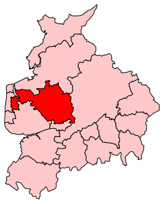
Thornton-Cleveleys is a conurbation consisting of the village of Thornton and the town of Cleveleys. The two settlements formed a joint urban district from 1927 until 1974, before becoming part of Wyre. The two settlements constitute part of the Blackpool Urban Area.

<span class="mw-page-title-main">Wyre and Preston North (UK Parliament constituency)</span> Parliamentary constituency in the United Kingdom, 2010 onwards

Wyre and Preston North is a county constituency represented in the House of Commons of the Parliament of the United Kingdom. Created in the most recent fifth periodic review of constituencies by the Boundary Commission for England, it elects one Member of Parliament (MP) by the first past the post voting system.

<span class="mw-page-title-main">Hambleton, Lancashire</span> Human settlement in England

Hambleton is a village and civil parish in the English county of Lancashire. It is situated on a coastal plain called the Fylde and in an area east of the River Wyre known locally as Over Wyre. Hambleton lies approximately 3 miles (4.8 km) north-east of its post town, Poulton-le-Fylde, and about 7 miles (11 km) north-east of the seaside resort of Blackpool. In the 2001 United Kingdom census, the parish had a population of 2,678, increasing to 2,744 at the 2011 census.

<span class="mw-page-title-main">Fylde North (UK Parliament constituency)</span> Parliamentary constituency in the United Kingdom, 1950–1983

Fylde North was a constituency which returned one Member of Parliament (MP) to the House of Commons of the Parliament of the United Kingdom from 1950, until it was abolished for the 1983 general election.

<span class="mw-page-title-main">Blackpool urban area</span> Built-up area in Lancashire, England

The Blackpool Built-up Area or Blackpool Urban Area is an urban area in Lancashire, England, consisting of the large town of Blackpool along with several surrounding towns and villages. Defined by the ONS it had a population of 239,409 in 2011 this is considerably down on the 2001 population of 261,088 mainly due to Fleetwood no longer being considered as part of the built-up area. The population of the Blackpool Urban Area has been declining for some time with the 2001 population down 0.1% from the 1991 figure of 261,355.

The Fylde is a coastal plain in western Lancashire, England. It is roughly a 13-mile-long (21-kilometre) square-shaped peninsula, bounded by Morecambe Bay to the north, the Ribble estuary to the south, the Irish Sea to the west, and the foot of the Bowland hills to the east which approximates to a section of the M6 motorway and West Coast Main Line.

<span class="mw-page-title-main">Pilling</span> Human settlement in England

Pilling is a village and civil parish within the Wyre borough of Lancashire, England. It is 6.5 miles (10.5 km) north-northeast of Poulton-le-Fylde, 9.4 miles (15.1 km) south-southwest of Lancaster and 14.5 miles (23.3 km) northwest of Preston, in a part of the Fylde known as Over Wyre.

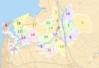
The FY postcode area, also known as the Blackpool postcode area, is a group of eight postcode districts in Lancashire, North West England. The districts cover the entire borough of Blackpool and the western parts of the boroughs of Wyre and Fylde. The letters in the postcode area name refer to the Fylde coastal plain. Its five post towns are Blackpool, Fleetwood, Lytham St Annes, Poulton-le-Fylde, Thornton-Cleveleys.

<span class="mw-page-title-main">Stalmine-with-Staynall</span> Parish in Wyre Borough, Lancashire, England

Stalmine-with-Staynall is a civil parish within the Wyre borough of Lancashire, England, in a part of the Fylde known as Over Wyre. The parish contains the village of Stalmine and the hamlets of Staynall and Wardley. The civil parish had a population of 1,486 at the 2011 Census, of which 1,087 lived in Stalmine village.

<span class="mw-page-title-main">Great Eccleston</span> Human settlement in England

Great Eccleston is a village and civil parish in Lancashire, England situated on a coastal plain called the Fylde. The village lies to the south of the River Wyre and the A586 road, approximately 10 miles (16 km) upstream from Fleetwood. At the 2001 census, the parish had a population of 1,473, rising slightly to 1,486 at the 2011 census.

<span class="mw-page-title-main">Burn Naze</span> Human settlement in England

Burn Naze is a residential area of Thornton-Cleveleys, in the Borough of Wyre, Lancashire, England. It is located about 5 miles (8 km) northeast of Blackpool and 2 miles (3 km) southeast of Fleetwood. Cleveleys is about 1.3 miles (2.1 km) to the west, while the River Wyre is about 0.8 miles (1.3 km) to the east.

Public transport in the Fylde is available for three modes of transport—bus, rail and tram—assisting residents of and visitors to the Fylde, a coastal plain in western Lancashire, England, without their own vehicle, to travel around much of the area's 64 square miles (170 km2).

References

  1. "Mid-Year Population Estimates, UK, June 2021". Office for National Statistics. 21 December 2022. Retrieved 18 October 2023.
  2. "Mid-Year Population Estimates, UK, June 2021". Office for National Statistics. 21 December 2022. Retrieved 18 October 2023.
  3. 1 2 UK Census (2021). "2021 Census Area Profile – Wyre Local Authority (E07000128)". Nomis. Office for National Statistics . Retrieved 5 January 2024.
  4. "The English Non-metropolitan Districts (Definition) Order 1972", legislation.gov.uk , The National Archives, SI 1972/2039, retrieved 22 August 2022
  5. "The English Non-metropolitan Districts (Names) Order 1973", legislation.gov.uk , The National Archives, SI 1973/551, retrieved 22 August 2022
  6. "District Councils and Boroughs". Parliamentary Debates (Hansard) . 28 March 1974. Retrieved 16 January 2012.
  7. "Council minutes, 12 May 2022". Wyre Council. Retrieved 20 October 2023.
  8. "Council minutes, 18 May 2023". Wyre Council. Retrieved 20 October 2023.
  9. Hunt, Richard (28 December 2022). "New Year brings in new start for Wyre Council's incoming chief executive Rebecca Huddleston". Blackpool Gazette. Retrieved 20 October 2023.
  10. "Local Government Act 1972", legislation.gov.uk , The National Archives, 1972 c. 70, retrieved 31 May 2023
  11. 1 2 3 "Election Maps". Ordnance Survey. Retrieved 17 October 2023.
  12. "Compositions calculator". The Elections Centre. Retrieved 20 August 2022.
  13. "Wyre". BBC News Online . Retrieved 23 October 2009.
  14. "Council minutes". Wyre Council. Retrieved 23 August 2022.
  15. "Peter Gibson former Wyre Council leader". Blackpool Gazette. 1 November 2018. Retrieved 23 August 2022.
  16. "Councillor details - Michael Vincent". wyre.moderngov.co.uk. 3 April 2023. Retrieved 3 April 2023.
  17. "Local elections 2023: live council results for England". The Guardian.
  18. "The Wyre (Electoral Changes) Order 2014", legislation.gov.uk , The National Archives, SI 2014/1187, retrieved 21 October 2023
  19. Storey, Christine (2012). Poulton-le-Fylde Through Time. Stroud: Amberley Publishing. p. 51. ISBN   978-1445630380 . Retrieved 23 August 2022.
  20. "Parish and Town Council clerks". Wyre Council. Retrieved 21 October 2023.
  21. "Mother of Fleetwood: Doreen Lofthouse's death leaves a community in mourning". April 2021.
  22. "The lozenge which took over the world".
  23. "Calls for statue to honour Doreen Lofthouse".
  24. "Soldiers are set to march through the streets of this Wyre town".
  25. "Duke of Lancaster's Regiment: Freedom of Entry to the Borough" (PDF). Wyre Council website. 21 August 2018.

53°54′00″N2°48′32″W / 53.900°N 2.809°W / 53.900; -2.809