Wyre Forest | |
---|---|
Sovereign state | United Kingdom |
Constituent country | England |
Region | West Midlands |
Non-metropolitan county | Worcestershire |
Status | Non-metropolitan district |
Admin HQ | Kidderminster |
Incorporated | 1 April 1974 |
Government | |
• Type | Non-metropolitan district council |
• Body | Wyre Forest District Council |
• MP | Mark Garnier |
Area | |
• Total | 75.4 sq mi (195.4 km2) |
• Rank | 147th (of 296) |
Population (2021 Census) | |
• Total | 101,600 |
• Rank | 237th (of 296) |
• Density | 1,300/sq mi (520/km2) |
Ethnicity (2021) | |
• Ethnic groups | |
Religion (2021) | |
• Religion | List
|
Time zone | UTC0 (GMT) |
• Summer (DST) | UTC+1 (BST) |
ONS code | 47UG (ONS) E07000239 (GSS) |
OS grid reference | SO8264776847 |
Wyre Forest is a local government district in Worcestershire, England. It is named after the ancient woodland of Wyre Forest. The largest town is Kidderminster, where the council is based. The district also includes the towns of Stourport-on-Severn and Bewdley, along with several villages and surrounding rural areas.
The district borders Bromsgrove District to the east, Wychavon to the south-east, Malvern Hills District to the south-west, Shropshire to the north-west, and South Staffordshire to the north.
The district was formed on 1 April 1974 under the Local Government Act 1972. The new district covered the area of four former districts, which were all abolished at the same time: [2]
The new district was named after the ancient woodland of Wyre Forest, much of which lies within the area. [3]
Since 2011, Wyre Forest has formed part of the Greater Birmingham & Solihull Local Enterprise Partnership.
Wyre Forest District Council | |
---|---|
Type | |
Type | |
Leadership | |
Ian Miller since December 2009 [5] | |
Structure | |
Seats | 33 Councillors |
Political groups |
|
Elections | |
Last election | 4 May 2023 |
Next election | 6 May 2027 |
Meeting place | |
Wyre Forest House, Finepoint Way, Kidderminster, DY11 7WF | |
Website | |
www |
Wyre Forest District Council provides district-level services. County-level services are provided by Worcestershire County Council. The whole district is also covered by civil parishes, which form a third tier of local government. [6]
The council has been under Conservative majority control since the 2023 election.
The first elections to the council were held in 1973, initially operating as a shadow authority alongside the outgoing authorities until the new arrangements took effect on 1 April 1974. Political control of the council since 1974 has been as follows: [7] [8] [9] [10] [11]
Party in control | Years | |
---|---|---|
No overall control | 1974–1976 | |
Conservative | 1976–1979 | |
No overall control | 1979–1996 | |
Labour | 1996–1999 | |
No overall control | 1999–2002 | |
Health Concern | 2002–2002 | |
No overall control | 2002–2008 | |
Conservative | 2008–2009 | |
No overall control | 2009–2010 | |
Conservative | 2010–2012 | |
No overall control | 2012–2015 | |
Conservative | 2015–2019 | |
No overall control | 2019–2023 | |
Conservative | 2023–present |
The leaders of the council since 1974 have been: [12] [13]
Councillor | Party | From | To | |
---|---|---|---|---|
Graham Smith [14] | Labour | 1974 | 1975 | |
Malcolm Cooper [15] | Conservative | 1975 | 1979 | |
Anthony Batchelor [16] | Liberal | 1979 | May 1983 | |
Graham Ballinger [17] | Conservative | 1983 | 1984 | |
Anthony Batchelor | Liberal | 1984 | 1985 | |
Mike Oborski | Liberal | 1985 | 1986 | |
Gilbert Edwards | Liberal | 1986 | 1989 | |
Jamie Shaw [18] | Labour | 1989 | 1994 | |
Jane Bonnick [19] [20] | Liberal Democrats | 1994 | Oct 1995 | |
Jamie Shaw [21] [22] | Labour | 1996 | 1999 | |
(no leader) | 1999 | 2000 | ||
Mike Oborski [23] [24] | Liberal | 2000 | 15 May 2002 | |
Liz Davies [25] | Health Concern | 15 May 2002 | 14 May 2003 | |
Howard Martin [26] | Health Concern | 14 May 2003 | 13 Jun 2004 | |
Stephen Clee | Conservative | 30 Jun 2004 | 16 May 2007 | |
John Campion | Conservative | 16 May 2007 | 2 Apr 2014 | |
Marcus Hart | Conservative | 2 Apr 2014 | 22 May 2019 | |
Graham Ballinger | Health Concern | 22 May 2019 | 12 May 2021 | |
Helen Dyke [19] | Independent | 12 May 2021 | 17 May 2023 | |
Marcus Hart | Conservative | 17 May 2023 |
Following the 2023 election and a change of allegiance in February 2024, the composition of the council was: [27] [28]
Party | Councillors | |
---|---|---|
Conservative | 20 | |
Independent | 7 | |
Labour | 3 | |
Liberal Democrats | 2 | |
Green | 1 | |
Total | 33 |
The Green councillor sits in a group with the independents. [29] The next election is due in 2027.
The council is based at Wyre Forest House, which was purpose-built for the council and completed in 2012. [30] The building is in the parish of Stourport-on-Severn, but lies on the outskirts of Kidderminster and has a Kidderminster postal address. Prior to 2012 the council was based at the Civic Centre on New Street in Stourport-on-Severn, which had been completed in 1966 for the old Stourport-on-Severn Urban District Council. [31]
Since the last boundary changes in 2015 the council has comprised 33 councillors representing 12 wards, with each ward electing one, two or three councillors. Elections are held every four years. [32]
The wards are: [32]
The Wyre Forest parliamentary constituency, which covers most of the district, is represented by the Conservative MP Mark Garnier. He has held the seat since the 2010 general election, when he gained it from Richard Taylor of Health Concern, who had held the seat from 2001 to 2010. [33]
In Wyre Forest, the population size has increased by 3.7%, from around 98,000 in 2011 to 101,600 in 2021. [34]
The whole district is divided into civil parishes. The parish councils for Bewdley, Kidderminster and Stourport-on-Severn take the style "town council". [35]
There are five secondary schools within the district.
Worcestershire is a ceremonial county in the West Midlands of England. It is bordered by Shropshire, Staffordshire, and the West Midlands county to the north, Warwickshire to the east, Gloucestershire to the south, and Herefordshire to the west. The city of Worcester is the largest settlement and the county town.
Kidderminster is a market town and civil parish in Worcestershire, England, 20 miles (32 km) south-west of Birmingham and 12 miles (19 km) north of Worcester. Located north of the River Stour and east of the River Severn, in the 2021 census, it had a population of 57,400. The town is twinned with Husum, Germany.
Bewdley is a town and civil parish in the Wyre Forest District in Worcestershire, England on the banks of the River Severn. It is in the Severn Valley, and is 3 miles (4.8 km) west of Kidderminster, 10 miles (16 km) North of Worcester and 25 miles (40 km) southwest of Birmingham. It lies on the River Severn, at the gateway of the Wyre Forest national nature reserve, and at the time of the 2011 census had a population of 9,470. Bewdley is a popular tourist destination and is known for the Bewdley Bridge, designed by Thomas Telford, and the well preserved Georgian riverside.
Stourport-on-Severn, often shortened to Stourport, is a town and civil parish in the Wyre Forest District of North Worcestershire, England, a few miles to the south of Kidderminster and downstream on the River Severn from Bewdley. At the 2021 census, it had a population of 20,653.
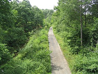
Wyre Forest is a large, semi-natural woodland and forest measuring 26.34 square kilometres (10.17 sq mi) which straddles the borders of Worcestershire and Shropshire, England. Knowles Mill, a former corn mill owned by the National Trust, lies within the forest.
Areley Kings is a village on the River Severn, in the civil parish of Stourport-on-Severn, in the Wyre Forest of Worcestershire, England. It is 10 miles north of Worcester and south of Stourport on Severn. It is in the Wyre Forest. The village is featured in the Domesday Book and is home to many historical places of interest such as Areley Hall and St Bartholomew's Church.
Kidderminster railway station is the main station serving the large town of Kidderminster, Worcestershire, England and the wider Wyre Forest district. The station is operated by West Midlands Trains, and is on the Birmingham to Worcester via Kidderminster Line. Regular commuter services run to Birmingham and Worcester. It shares its station approach with the adjacent Severn Valley Railway station.
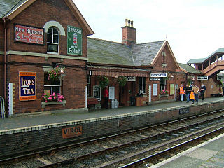
Bewdley railway station serves the town of Bewdley in Worcestershire, England. Until 2014, it was the administrative headquarters of the Severn Valley Railway, after which they were moved to Comberton Hill, Kidderminster. Bewdley is the principal intermediate station on the line.
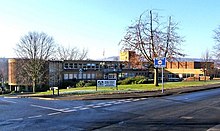
The Bewdley School is a senior school and sixth form in Bewdley, serving north-west Worcestershire, England. Its campus is very close to the River Severn and lies on the border of the Wyre Forest national nature reserve. Bewdley is an educational research partner of the University of Worcester and University of Birmingham and is recognised for its focus on international and cultural education. In 2019, Bewdley hosted the Global Happiness Conference in partnership with the British Council. The Bewdley School has close ties with the nearby Bewdley Rowing Club established in 1877.
The 2002 Wyre Forest District Council election took place on 2 May 2002 to elect members of Wyre Forest District Council in Worcestershire, England. One third of the council was up for election and the Independent Kidderminster Hospital and Health Concern party gained overall control of the council from no overall control.
The 2003 Wyre Forest District Council election took place on 1 May 2003 to elect members of Wyre Forest District Council in Worcestershire, England. One third of the council was up for election and the council stayed under no overall control.
The 2004 Wyre Forest District Council election took place on 10 June 2004 to elect members of Wyre Forest District Council in Worcestershire, England. The whole council was up for election with boundary changes since the last election in 2003. The council stayed under no overall control, but with the Conservatives taking over as the largest party on the council from the Health Concern party.
The 2008 Wyre Forest District Council election took place on 1 May 2008 to elect members of Wyre Forest District Council in Worcestershire, England. One third of the council was up for election and the Conservative Party gained overall control of the council from no overall control.
The 2011 Wyre Forest District Council election took place on 5 May 2011 to elect members of Wyre Forest District Council in Worcestershire, England. One third of the council was up for election and the Conservative Party stayed in overall control of the council.
The 2014 Wyre Forest District Council election took place on 22 May 2014 to elect members of Wyre Forest District Council in Worcestershire, England. One third of the council was up for election and the council stayed under no overall control.
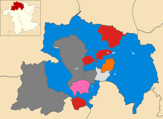
The 2015 Wyre Forest District Council election took place on 7 May 2015 to elect members of Wyre Forest District Council in Worcestershire, England. The whole council was up for election after boundary changes reduced the number of seats by nine. The Conservative Party gained overall control of the council from no overall control.
The 2018 Wyre Forest District Council election took place on 3 May 2018 to elect members of the Wyre Forest District Council in Worcestershire, England. They were held on the same day as other local elections.