Upton-upon-Severn

Last updated

Upton-upon-Severn
Tudor House Museum, Upton upon Severn - geograph.org.uk - 2533444.jpg
Worcestershire UK location map.svg
Red pog.svg
Upton-upon-Severn
Location within Worcestershire
Population2,881 (2011)
OS grid reference SO852405
  London 114 miles (183 km)
Civil parish
  • Upton-upon-Severn
District
Shire county
Region
Country England
Sovereign state United Kingdom
Post town Worcester
Postcode district WR8
Dialling code 01684
Police West Mercia
Fire Hereford and Worcester
Ambulance West Midlands
UK Parliament
List of places
UK
England
Worcestershire
52°03′47″N2°12′54″W / 52.063°N 2.215°W / 52.063; -2.215

Upton-upon-Severn (or Upton on Severn, etc. and locally simply Upton) is a town and civil parish in the Malvern Hills District of Worcestershire, England. Lying on the A4104 (formerly A440), the 2021 census recorded a population of 2,903 for the town. [1]

Contents

Upton is situated on the west bank of the River Severn and is located 5 miles (8 km) southeast of Malvern. The town has a distinctive tower and copper-clad cupola – known locally as the "Pepperpot" – the only surviving remnant of the former church. Its replacement, also dedicated to St Peter and St Paul, was designed by Sir Arthur Blomfield. [2]

History

Upton-upon-Severn Memorial Hall Memorial Hall, Upton-upon-Severn - geograph.org.uk - 928228.jpg
Upton-upon-Severn Memorial Hall

Until the later half of the 20th century, the bridge at Upton was the only one across the River Severn between Worcester and Tewkesbury; the present bridge was built in 1940. [3] Oliver Cromwell's soldiers crossed the Severn here to win the battle of Upton before the main Battle of Worcester in the English Civil War. The Upton-upon-Severn Memorial Hall was completed in 1832. [4]

Today

The population of the civil parish in 2021 was recorded at 2,903 [5] - an increase from 2,881 in 2011. [6] The parish extends westward from the town, including the settlement at Tunnel Hill, but does not include the village of Ryall located close to the town, on the other side of the river. Upton is in the West Worcestershire parliamentary constituency.

Upton lies on the banks of the River Severn and is known for its regular flooding. [7] Low-lying areas of Upton suffered serious flooding in 2000. In the 2007 floods, levels exceeded those in 2000, and the town was inaccessible by road. [8] The town's main built up area lies on slightly higher ground than the surrounding countryside, and in the past became an island during severe floods. A connecting causeway now carries the A4104 above the floods to the west, and a viaduct on the other side of the bridge to the east.

The town has three major music festivals, with the spring folk festival, and the summer jazz and blues festivals. [9]

Upton is the home of The White Lion Hotel, a 16th-century coaching inn, where parts of the building date back to 1510. The building has undergone many transformations over the centuries and is easily found on the high street due to its distinctive portico, adorned with its very own lion. Reputed to have played a part in the English Civil War, where soldiers from both sides are alleged to have enjoyed the hospitality of this popular local hostelry prior to the Battle of Worcester. Guests of the hotel can stay in rooms referred to in books VII and VIII of Henry Fielding's classic 1749 novel Tom Jones in which he refers to the hotel as "A house of exceeding good repute"; [10] these rooms retain many of their original features.

Education

Primary education is provided by Upton-upon-Severn CofE Primary School with approximately 194 (2019) pupils on role. [11] Hanley Castle High School, located in a nearby village, provides secondary education for the region.

People

The 'Pepperpot' - remains of the former church of St Peter and St Paul. Its nave was demolished in 1937. Pepperpot Upton.jpg
The 'Pepperpot' – remains of the former church of St Peter and St Paul. Its nave was demolished in 1937.

Transport

The bridge at Upton-upon-Severn Upton-upon-Severn bridge 929084.jpg
The bridge at Upton-upon-Severn

Upton used to be served by Upton-on-Severn railway station, on a branch line Tewkesbury and Malvern Railway from Ashchurch to Malvern, with the intermediate stations Tewkesbury, Ripple, Worcestershire, Upton upon Severn and Malvern Wells (Hanley Road). [16] The Upton to Malvern section closed in December 1952 and the rest in August 1961, before the Beeching Axe.

Bus services 332 and 363 link Upton to Worcester a total of six times per day (Mon-Fri), with four per day on Saturdays. [17]

Although the M5 motorway is close by, the nearest motorway junction is Junction 1 of the M50 (which is 2 miles or 3.2 km from J8 of the M5).

Upton Marina is home to Mercia Inshore Search and Rescue.

Related Research Articles

<span class="mw-page-title-main">Tewkesbury</span> Town and civil parish in England

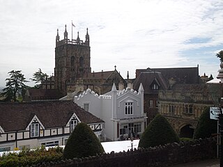
Tewkesbury is a market town and civil parish in the north of Gloucestershire, England. The town grew following the construction of Tewkesbury Abbey in the twelfth century and played a significant role in the Wars of the Roses. It stands at the confluence of the River Severn and the River Avon, and thus became an important trading point, which continued as railways and, later, the M5 and M50 motorway connections were established. The town gives its name to the Borough of Tewkesbury, a local government district of Gloucestershire. The town lies on the border with Worcestershire, marked largely by the Carrant Brook.

<span class="mw-page-title-main">Malvern Hills District</span> Non-metropolitan district in England

Malvern Hills is a local government district in Worcestershire, England. Its council is based in Malvern, the district's largest town. The district also includes the towns of Tenbury Wells and Upton-upon-Severn and a large rural area covering much of the western side of the county, including numerous villages. The district is named after the Malvern Hills, which are a designated Area of Outstanding Natural Beauty.

<span class="mw-page-title-main">Malvern Wells</span> Human settlement in England

Malvern Wells is a village and civil parish south of Great Malvern in the Malvern Hills district of Worcestershire, England. The parish, once known as South Malvern, was formed in 1894 from parts of the civil parishes of Hanley Castle, Welland, and the former parish of Great Malvern, and owes its development to the 19th-century boom years of Malvern as a spa town. Malvern Wells is a centre of commercial bottling of Malvern water. The population of the parishes of Malvern Wells and Little Malvern was recorded in 2011 as 3,196.

<span class="mw-page-title-main">Barnards Green</span> Human settlement in England

Barnards Green is one of the main population areas of Malvern, Worcestershire, England, situated approximately 1 mile (1.6 km) east and downhill from Great Malvern, the town's traditional centre.

<span class="mw-page-title-main">North Malvern</span> Human settlement in England

North Malvern is a suburb of Malvern, Worcestershire, England. It nestles on the northern slopes of the Malvern Hills. It is a contiguous urban extension of Link Top, and other neighbouring centres of population are Great Malvern, Malvern Link, West Malvern and the former village of Cowleigh. It is part of the civil parish of Malvern, administered by the Malvern Hills District, and is included in the informal region known as The Malverns.

<span class="mw-page-title-main">Kempsey, Worcestershire</span> Human settlement in England

Kempsey is a village and civil parish in the Malvern Hills District in the county of Worcestershire, England. It is bounded by the River Severn on the west, and the A38 main road runs through it and is about 3 miles (5 km) south of Worcester. The village has a long history. Its name is derived from the Saxon "Kemys' Eye", or the island of Kemys. Kemys was a Saxon chief, whose island lay between marshes and the River Severn. One of the roads in Kempsey, Lyf's Lane, is named after another Saxon chief. The village was recorded in the 11th century Domesday Book as having a value of £7.

<span class="mw-page-title-main">Ashchurch</span> Village in Gloucestershire, England

Ashchurch is a village and former civil parish, now in the parish of Ashchurch Rural, in the Tewkesbury district, in the county of Gloucestershire, England, 2 miles (3.2 km) east of the town of Tewkesbury, 11 mi (18 km) southwest of Evesham, 10 mi (16 km) north of Cheltenham, 13 mi (21 km) north-north-east of Gloucester and 10 mi (16 km) south of Pershore.

<span class="mw-page-title-main">Hanley Castle</span> Human settlement in England

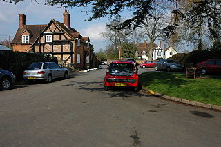
Hanley Castle is a village and civil parish in Worcestershire, England, between the towns of Malvern and Upton upon Severn and a short distance from the River Severn. It lies in the administrative area of Malvern Hills District, and is part of the informal region known as The Malverns. It is served primarily by bus service 332 Worcester - Upton upon Severn - Hanley Castle operated by Aston Coaches and 363 Worcester - Tewkesbury operated by First Worcester.

<span class="mw-page-title-main">Hanley Swan</span> Human settlement in England

Hanley Swan is a small village in the English county of Worcestershire. It lies in the Malvern Hills district, between the towns of Malvern and Upton-upon-Severn. Together with the nearby village of Hanley Castle, its population is about 1500. The traditional English village centre includes a village green and pond, a pub, a Social Club and a village stores. Hanley Swan won the 2009 Calor Herefordshire and Worcestershire Village of the Year competition, a heat of the national Village of the year competition. Hanley Swan was an inspiration for the setting of the novel Black Swan Green by David Mitchell.

<span class="mw-page-title-main">Welland, Worcestershire</span> Human settlement in England

Welland is a village and civil parish in the administrative district of Malvern Hills in the county of Worcestershire, England. It has a combined parish council with Little Malvern, with 9 of the 11 councillors. It is about 6 miles (9.7 km) from the town of Malvern, 15 miles from the city of Worcester, and 18 miles from the city of Gloucester. It is surrounded by farms and common land, and is part of the informal region referred to as The Malverns.

<span class="mw-page-title-main">Ripple, Worcestershire</span> Human settlement in England

Ripple is a village and civil parish in the county of Worcestershire, England. Ripple is one of the most southerly parishes in the county and is situated on the A38 road with the River Severn as its western boundary. Besides Ripple, the parish contains the settlements of Holly Green, The Grove, Naunton, Ryall, Saxon's Lode, and Uckinghall. It had a combined population of 1,799 at the 2011 census.

<span class="mw-page-title-main">Hanley Castle High School</span> Academy in Worcestershire, England

Hanley Castle High School is a non-selective mixed secondary school and sixth form centre located in the village of Hanley Castle, 1.4 miles (2.2 km) from the small town of Upton-upon-Severn, Worcestershire. It was formerly known as Hanley Castle Grammar School, and was probably founded in 1326, making it one of the oldest schools in England.

<span class="mw-page-title-main">Strensham</span> Human settlement in England

Strensham is a village in the Wychavon district of Worcestershire. In the 2001 census, the civil parish of Strensham had a population of 314 across 127 households. Since 1991, the population has risen 28.7% from 244 residents.

<span class="mw-page-title-main">Poolbrook</span> Human settlement in England

Poolbrook is a village and a suburb of Malvern, Worcestershire, England, situated approximately 1.5 miles (2.4 km) southeast of Great Malvern, the town's centre, and about 0.5 miles (08 km) from the Malvern suburb of Barnards Green on the Poolbrook Road (B4208). The village comprises several shops, a traditional English pub, and a number of council and private housing estates. St Andrew's C of E parish church was built in Early English style in 1882 as a memorial to a member of the Chance Brothers glass manufacturing family. The village occupies the geographical centre of the Chase ward of Malvern Town Council.

<span class="mw-page-title-main">Link Top</span> Human settlement in England

Link Top is a locality of Malvern Link, a major population area of the town of Malvern, Worcestershire, England. It is situated at the western extremity of Malvern Link at its boundary with Great Malvern and North Malvern. It is centred on a sharp left hand bend in the Worcester Road (A449) that forms a complex junction with the North Malvern Road, Hornyold Road, Newtown Road, and Lygon Bank,

<span class="mw-page-title-main">Sherrard's Green</span> Human settlement in England

Sherrard's Green is a village and a suburb of Malvern, Worcestershire, England, situated approximately 1.5 miles southeast of Great Malvern, the town's centre, and about 0.5 miles (0.80 km) from the Malvern suburb of Barnards Green. The village comprises a number of council and private housing estates and the small parish church of St Mary's, Pickersleigh, and a Tesco convenience store that opened in 2011 on the site of a former pub, The New Gas Tavern.

<span class="mw-page-title-main">Tewkesbury and Malvern Railway</span>

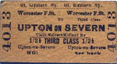
The Tewkesbury and Malvern Railway was a branch of the Midland Railway which ran from Ashchurch via Tewkesbury to Great Malvern in the United Kingdom. It was opened on 16 May 1864. At grouping in 1923 it became part of the London Midland and Scottish Railway.

<span class="mw-page-title-main">Malvern Chase</span> Royal chase in England

Malvern Chase was a royal chase that occupied the land between the Malvern Hills and the River Severn in Worcestershire and extended to Herefordshire from the River Teme to Cors Forest.

References

  1. "Upton-upon-Severn (Parish, United Kingdom) - Population Statistics, Charts, Map and Location". citypopulation.de. Retrieved 7 August 2023.
  2. "History of the Old Church" (PDF). www.upton.uk.net. Retrieved 10 December 2011.
  3. "The Bridge at Upton" (PDF). www.upton.uk.net. Retrieved 10 December 2011.
  4. Historic England. "Memorial Hall (1227111)". National Heritage List for England . Retrieved 10 April 2024.
  5. "Neighbourhood Statistics". Office for National Statistics . Retrieved 23 January 2016.
  6. ONS 2001 census: parish headcount
  7. Clare Lissaman, Downpours shocked 'most flooded' town Upton upon Severn, BBC News, 20 July 2012.
  8. "July 2007 Floods". www.upton.uk.net. Retrieved 10 December 2011.
  9. "Upton Blues Festival". Upton Blues Festival. Retrieved 4 January 2020.
  10. Fielding, Henry (1861). Tom Jones. Derby. p.  149 . Retrieved 10 December 2011. tom jones exceeding good repute.
  11. "Upton-upon-Severn CofE Primary School - Profile (2023)". snobe.co.uk. Retrieved 7 August 2023.
  12. Fell Smith, Charlotte (1909). John Dee: 1527–1608. London: Constable and Company.
  13. "House that gave birth to a legend". Worcester News. 8 August 2003. Retrieved 10 July 2021.
  14. "William Tennant - alias Dunkirk Joe". BBC Hereford and Worcestershire. 24 September 2014. Retrieved 25 March 2018.
  15. Houtermann, Hans. "British Army Officers, 1939–1945 (G.M.B. Wadsworth to G.A. Weir)". World War II unit histories. Retrieved 28 December 2010.
  16. "Upton Ticket". www.miac.org.uk. Railways in Worcestershire. Retrieved 10 December 2011.
  17. Traveline Midlands bus search (searched 2 December 2020)

Further reading