Shrawley

Last updated

Shrawley
The New Inn, Shrawley - geograph.org.uk - 111545.jpg
The New Inn in Shrawley, on the B4196
Worcestershire UK location map.svg
Red pog.svg
Shrawley
Location within Worcestershire
Population356 (2001)[ needs update ]
OS grid reference SO806649
Civil parish
  • Shrawley
District
Shire county
Region
Country England
Sovereign state United Kingdom
Post town Worcester
Postcode district WR6
Police West Mercia
Fire Hereford and Worcester
Ambulance West Midlands
UK Parliament
List of places
UK
England
Worcestershire
52°16′55″N2°17′05″W / 52.281985°N 2.28473°W / 52.281985; -2.28473 Coordinates: 52°16′55″N2°17′05″W / 52.281985°N 2.28473°W / 52.281985; -2.28473

Shrawley is a village and civil parish in the Malvern Hills District in the county of Worcestershire, England. The village is situated on the western bank of the River Severn. The northern and southern boundaries of the parish are two small tributaries of the River Severn, Dick Brook to the north and Shrawley Brook to the south. To the west is Hillhampton, the north west and north is the parish of Astley and to the south Holt.

Contents

The B4196 road runs throughout the village from the A433 at the Holt Heath boundary in the south to the Astley boundary at Glazenbridge on Dick Brook in the north.

There are 22 miles of footpaths around Shrawley. [1]

Education

Shrawley Primary School closed in 1977 (is now the village hall) and all the children of the village, between 4 and 11 years old, go to the CoE school at Great Witley. On leaving Great Witley school the 11 to 16s go on to The Chantry School at Martley. [2]

History

Following the Norman conquest of England, what is now known as Shrawley was part of the lower division of the Doddingtree Hundred. [3] It consisted of a series of scattered hamlets, and as such did not appear in the Domesday Book of 1086. The main hamlets were Frog Pool, Great Shrawley, Noutard's Green and Sankyns Green. [4]

In 1645 the number of Civil War deserters increased rapidly and Shrawley Wood was said to swarm with bandits and refugees. [5] Close to the River Severn within Shrawley Woods are the remains of Oliver Mount, a former castle. In its ruins was found a piece of stone with carving matching the font in the church. [6]

In 1700 the Manor of Shrawley came up for sale by the Cliffe family, and after investigating the prospects, which included timber from Shrawley Great Wood of over 300 acres (1.2 km2), Thomas Vernon (1665–1721), of Hanbury Hall, acquired it for £13,000, equivalent to £2 million in June 2014.

Following the Poor Law Amendment Act 1834 Shrawley Parish ceased to be responsible for maintaining the poor in its parish. This responsibility was transferred to Martley Poor Law Union. [7]

Shrawley remained an important Vernon family possession through to about 1980 when the heir to the last member of the Vernon family, living in Shrawley Wood House, died.

The village hall was built in 1860 as a National School.

Population

The following is a partial history of the population of Shrawley, recorded at censuses since 1871: [4]

CensusPopulation
1871519
1901 414
1921384
1931414
1981348
2001 355
2011 423
View of the River Severn from the eastern edge of Shrawley Wood The River Severn, Shrawley - geograph.org.uk - 140088.jpg
View of the River Severn from the eastern edge of Shrawley Wood

Shrawley Wood

In 1955 Shrawley Wood (103.1 hectares or 254.8 acres), was designated as a Site of Special Scientific Interest because of its Biological interest. [8] The site was selected because it is a large tract of ancient woodland almost completely dominated by coppiced Small-leaved Lime. "...This type of woodland is a feature of eastern England and its occurrence here is unusual in the West Midlands. The woodland also has a long history of management with records going back to the beginning of the eighteenth century. ... The streams and pools included in this site add to the site's conservation value ... the rare soft hornwort occurs in one of the pools. Over 400 species of fungi have been recorded in the woodland. ...". [8]

Church of St Mary

St Mary's church St Mary's church, Shrawley - geograph.org.uk - 111544.jpg
St Mary's church

The parish church, St Mary, dates back to around 1100 [9] and is a Grade I listed building. [10] It has 14th and 15th century windows and crenellated parapets, 16th century south porch, 17th century tower and 19th century work throughout show continuous development of the building. [11]

On 1 April 1978 the ownership of the Rector's Glebe Land, in Shrawley, which consisted of 128 acres of land and a small wood was transferred from the Rector's ownership to that of the Diocese of Worcester, [12] in line with the rest of the UK.

In the autumn of 1978 the ecclesiastical Parish of Shrawley was amalgamated with that of the neighbouring parish of St Michael's, Great Witley, together with its chapel in Little Witley, to form a single parish of Shrawley and The Witleys [12] and with Abberley to form a united Benefice. Shrawley church is in the Stourport Deanery.

The church has a virtually complete set of high box pews.

The reredos is by William Percival Starmer (1877–1961). [13] Behind and above the reredos is a stained glass window by James Powell and Sons installed in 1921. [14]

On the west wall of the West End Gallery are the coat of arms of George III. [14] and two hatchments. The most southern of these that of Thomas Shrawley Vernon.

On the right hand of the doors, in the porch, is a Norman holy water stoup which survived the Reformation. [15]

Immediately on the left inside the church is a Norman font with trumpet scallop carving and an elaborate 17th century wooden conical cover. [16]

Just outside the porch of the church is a base of a medieval stone cross. This is a Scheduled Ancient Monument. The cross itself was destroyed during the Civil War. It is now mounted by a horizontal sundial made by Samuel Thorp in 1819 and inscribed, "Ab Hoc Momento pendet Aeternitas." [17] It has been suggested that the cross may have been used by peripatetic priests, as a Preaching cross, before the church building and the church itself was deliberated built to the north of the cross itself beyond the shadow of the cross. [18]

The tower contains a ring of 6 bells.

Related Research Articles

Worcestershire County of England

Worcestershire is a county in the West Midlands of England.

Malvern Hills District Non-metropolitan district in England

Malvern Hills is a local government district in Worcestershire, England. Its council is based in the town of Malvern, and its area covers most of the western half of the county, including the small towns of Tenbury and Upton. It was originally formed in 1974 and was subject to a significant boundary reform in 1998. In the 2011 census the population of the Malvern Hills district was 74,631.

Abberley Human settlement in England

Abberley is a village and civil parish in north west Worcestershire, England.

Areley Kings Human settlement in England

Areley Kings is a Worcestershire village on the River Severn 10 miles north of Worcester in the picturesque area of the Wyre Forest. The area is featured in the Domesday Book and many historical places of interest, like Areley Hall, are open to visitors. Nearby Stourport-on-Severn grew during the Victorian era and is still very popular with tourists and holiday makers all year round for canal and river cruising and for the many well signed walks through some of the finest Worcestershire countryside.

Leigh, Worcestershire Human settlement in England

Leigh is a village and civil parish in the Malvern Hills district of the county of Worcestershire, England.

Great Witley Human settlement in England

Great Witley is a village and civil parish, in the Malvern Hills District in the northwest of the county of Worcestershire, England. It is situated around ten miles to the north west of the city of Worcester.

Martley Human settlement in England

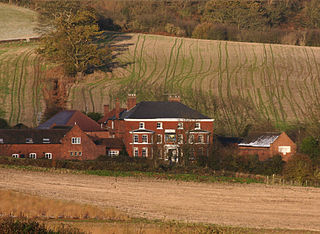
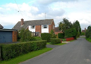
Martley is a village and civil parish in the Malvern Hills district of the English county of Worcestershire. It is approximately nine miles north-west of Worcester. The population of the village is approximately 1,200 people. The mixed farming of the area includes arable, formerly cherry, apple, damson orchards and hopyards.

Alfrick Human settlement in England

Alfrick is a village and civil parish in the Malvern Hills district of Worcestershire, England, about seven miles west of Worcester.

Broadwas Human settlement in England

Broadwas, or Broadwas-on-Teme, is a village and civil parish in the Malvern Hills district of Worcestershire, England. According to the 2001 census it had a population of 307. The village is located on the River Teme, about 6 miles west of Worcester on the A44 road.

Suckley Human settlement in England

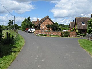
Suckley is a village and civil parish in the Malvern Hills District in the county of Worcestershire, England, close to the border with Herefordshire. The parish includes the hamlets of Suckley Knowl, Suckley Green at SO719532 and Longley Green at SO733503.

Holt, Worcestershire Human settlement in England

Holt is a village in the Wychavon district of the county of Worcestershire, England. The church is dedicated to St. Martin, and dates from about the 12th century. Holt Bridge, over the River Severn, was designed by Thomas Telford, and opened in 1830.

Little Witley Human settlement in England

Little Witley is a village and civil parish in the Malvern Hills District in the county of Worcestershire, England.

Astley, Worcestershire Human settlement in England

Astley is a village, and a civil parish in Worcestershire, England, about two miles outside Stourport-on-Severn and seven miles south-west of Kidderminster.

Hillhampton is a hamlet and civil parish nestled between Great Witley, Little Witley and Shrawley in the Malvern Hills district of the county of Worcestershire, England. It was anciently a detached hamlet of the parish of Martley.

Croome DAbitot Human settlement in England

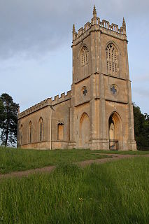
Croome D'Abitot is a village and civil parish, which shares a joint parish council with Severn Stoke, in the Malvern Hills District in the county of Worcestershire, England. The parish church of St Mary Magdalene is situated in the grounds of Croome Court.

Anthony Keck

Anthony Keck (1726–1797) was an 18th-century English architect with an extensive practice in Gloucestershire, Worcestershire, Herefordshire and South Wales.

The Hundred of Doddingtree was granted to Ralph Todeni, or Ralph de Toni, a relative of the Duke of Normandy, in 1066 by William the Conqueror as a reward for his services as Standard bearer during the Norman Conquest. It consisted mainly of west Worcestershire.

Following the Poor Law Amendment Act 1834 individual parishes ceased to be responsible for maintaining the poor in their parish. Poor law unions were established. In west Worcestershire the Martley Poor Law Union was established to take the poor from the following parishes Abberley, Alfrick, Astley, Bransford, Broadwas, Clifton-upon-Teme, Cotheridge, Doddenham, Great Witley, Grimley, Hallow, Holt, Knightwick, Leigh, Little Witley, Lulsley, Martley, Pensax, Shelsley, Shrawley, Suckley and Wichenford.

Samuel Thorp, or Thorpe, was a clockmaker born in Madeley, Shropshire. He was baptized 6 January and became apprenticed in 1780 to a renowned Shrewsbury Clockmaker Robert Webster. On 20 December 1790 he married Mary Newall at Ford, Shropshire. Samuel Thorp died in 1838 and was buried in Abberley Churchyard in Worcestershire on 15 February. Mary joined him there on 19 February 1843.

Shelsley Beauchamp Human settlement in England

Shelsley Beauchamp or Great Shelsley is a village and civil parish 9 miles (14 km) north west of Worcester, in the Malvern Hills district, in the county of Worcestershire, England. In 2011 the parish had a population of 192. It is on the opposite bank of the River Teme to Shelsley Walsh. The parish touches Clifton upon Teme, Great Witley, Martley, Shelsley Kings and Shelsley Walsh. It shares a parish council with Shelsley Kings and Shelsley Walsh called the Shelsley Parish Council.

References

  1. Ray Mace A potted History of Glasshampton Lodge, n.d., manuscript, Shrawley, Worcestershire.
  2. The Chantry School Admissions Map Accessed 8 June 2014 Archived 3 June 2014 at the Wayback Machine
  3. Worcestershire Family History Guidebook, Vanessa Morgan, 2011, p20 The History Press, Stroud, Gloucestershire.
  4. 1 2 "Shrawley through the Ages: The Parish of Shrawley to celebrate the Ninth Centenary of St Mary's Church" (PDF). Within Living Memory. July 1982.
  5. Malcolm Atkin 1995 The Civil War in Worcestershire, p83 Alan Sutton Publishing, Stroud, Gloucestershire quoting British Library E.279 (1) and E.281 (3)
  6. Arthur Mee (editor), Worcestershire, 1938, p221 Hodder & Stoughton, London.
  7. Worcestershire Family History Guidebook, Vanessa Morgan, 2011, p68 The History Press, Stroud, Gloucestershire.
  8. 1 2 Natural England Citation dated 12 May 1986
  9. "Parishes: Shrawley". A History of the County of Worcester: volume 4. Victoria County History. 1924. Retrieved 29 November 2010.
  10. Historic England. "Details from listed building database (1082650)". National Heritage List for England . Retrieved 8 June 2014.
  11. Jane Chamberlain (12 August 2013). Report on the Quinquennial Survey for 2013 (Report). Ledbury. p. 4.
  12. 1 2 "Memory Lane". Shrawley and the Witleys Parish Magazine. September 2013. p. 17.
  13. "Walter Percival Starmer – Inventory of Work". walterpstarmer.com (blog). Retrieved 13 May 2014.
  14. 1 2 Pevsner, Nikolas and Brookes, Alan Worcestershire 2007 Yale University Press p595 ISBN   9780300112986
  15. Tim Bridges Churches of Worcestershire Logaston Press, Herefordshire 2000 rev ed. 2005 p13 ISBN   1 904396 39 9
  16. Tim Bridges Churches of Worcestershire Logaston Press, Herefordshire 2000 rev ed. 2005 pages 15 and 206 ISBN   1 904396 39 9
  17. Victoria County History A History of the County of Worcester: volume 4 William Page, J.W.Willis-Bund (editors) 1924. Retrieved10 May 2014.
  18. Palmer, Roy The Folklore of Worcestershire Logaston Press, Herefordshire 2005 p58 ISBN   1 904396 40 2