
Worcester is a cathedral city in Worcestershire, England, of which it is the county town. It is 30 mi (48 km) south-west of Birmingham, 27 mi (43 km) north of Gloucester and 23 mi (37 km) north-east of Hereford. The population was 103,872 in the 2021 census.

Malvern is a spa town and civil parish in Worcestershire, England. It lies at the foot of the Malvern Hills, a designated Area of Outstanding Natural Beauty. The centre of Malvern, Great Malvern, is a historic conservation area, which grew dramatically in Victorian times due to the natural mineral water springs in the vicinity, including Malvern Water.

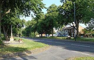
Malvern Wells is a village and civil parish south of Great Malvern in the Malvern Hills district of Worcestershire, England. The parish, once known as South Malvern, was formed in 1894 from parts of the civil parishes of Hanley Castle, Welland, and the former parish of Great Malvern, and owes its development to the 19th-century boom years of Malvern as a spa town. Malvern Wells is a centre of commercial bottling of Malvern water. The population of the parishes of Malvern Wells and Little Malvern was recorded in 2011 as 3,196.

Malvern Link is an area of Malvern, Worcestershire, England to the north and east of Great Malvern. The centres of Malvern Link and Great Malvern are separated by Link Common, an area of open land that is statutorily protected by the Malvern Hills Conservators. In 1900 Malvern Link Urban District, which had been formed only five years earlier, merged with Great Malvern to become Malvern Town. The population of Link in 2011 was 6,155.

Welford is a village and civil parish in the West Northamptonshire unitary authority area of Northamptonshire, England, just south of the River Avon and the border with Leicestershire. At the 2011 Census, the population of the parish was 1,043.
Hillmorton is a suburb of Rugby, Warwickshire, England, around 2 miles (3.2 km) south-east of Rugby town centre, forming much of the eastern half of the town. It is also a ward of the Borough of Rugby. Hillmorton was historically a village in its own right, but was incorporated into Rugby in 1932. Hillmorton also encompasses the Paddox housing estate to the west of the old village, which is shown on many maps as 'Hillmorton Paddox', this area however is part of a separate ward called 'Paddox'.

Great Glen is a village and civil parish in the Harborough district, in Leicestershire, 2 miles south of Oadby. The population of the civil parish at the 2011 census was 3,662. Leicester city centre is about seven miles north west. Its name comes from the original Iron Age settlers who used the Celtic word glennos meaning valley, and comes from the fact that Great Glen lies in part of the valley of the River Sence. The 'great' part is to distinguish the village from Glen Parva.

Duston is a suburb of Northampton and a civil parish in West Northamptonshire, England.

Kempsey is a village and civil parish in the Malvern Hills District in the county of Worcestershire, England. It is bounded by the River Severn on the west, and the A38 main road runs through it and is about 3 miles (5 km) south of Worcester. The village has a long history. Its name is derived from the Saxon "Kemys' Eye", or the island of Kemys. Kemys was a Saxon chief, whose island lay between marshes and the River Severn. One of the roads in Kempsey, Lyf's Lane, is named after another Saxon chief. The village was recorded in the 11th century Domesday Book as having a value of £7.
Shiplake consists of three settlements: Shiplake, Shiplake Cross and Lower Shiplake. Together these villages form a civil parish situated beside the River Thames 2 miles (3 km) south of Henley-on-Thames, Oxfordshire, England. The river forms the parish boundary to the east and south, and also the county boundary between Oxfordshire and Berkshire. The villages have two discrete centres separated by agricultural land. The 2011 Census records the parish population as 1,954 and containing 679 homes. The A4155 main road linking Henley with Reading, Berkshire passes through the parish.
Abbotts Ann is a village in the parish of the same name, approximately 2 miles (3.2 km) south-west of Andover, Hampshire, England. The population of the civil parish at the 2011 Census, including Little Ann and Red Post Bridge, was 2,566.

Wilmcote is a village, and since 2004 a separate civil parish, in the English county of Warwickshire, about 3 miles (5 km) north of Stratford-upon-Avon. Prior to 2004, it was part of the same parish as Aston Cantlow, and the 2001 population for the whole area was 1,670, reducing to 1,229 at the 2011 Census.

Birling is a village and civil parish in the Tonbridge and Malling district of Kent, England, about seven miles west of Maidstone. According to the 2001 census it had a population of 430 increasing to 437 at the 2011 Census: 224 male and 213 female. It is south-west of the nearby town of Snodland and 37 miles away from the capital.

Powick is a village and civil parish in the Malvern Hills district of Worcestershire, England, located two miles south of the city of Worcester and four miles north of Great Malvern. The parish includes the village of Callow End and the hamlets of Bastonford, Clevelode, Collett's Green, and Deblins Green.

Clent is a village and civil parish in the Bromsgrove District of Worcestershire, England, southwest of Birmingham and close to the edge of the West Midlands conurbation. At the 2001 census it had a population of 2,600.

Spurstow is a village and civil parish in the unitary authority of Cheshire East and the ceremonial county of Cheshire, England, which is located 6½ miles to the north west of Nantwich. The parish also includes the settlement of Spurstow Sketh and part of Radmore Green. The total population is a little over 400 people. Nearby villages include Bunbury, Haughton and Peckforton. The parish is mentioned in the Domesday Book of 1086 and contains a salt spring, which was formerly used as a spa.

The Firs in Lower Broadheath, Worcestershire, England was the birthplace of Edward Elgar. The cottage now houses a museum administered by the National Trust. Edward Elgar was born at the house on 2 June 1857, and lived there for the first two years of his life. The museum comprises the Birthplace Cottage and its garden, and the modern Elgar Centre, opened in 2000, which houses further exhibitions and a function room.

Riby is a village and civil parish in the West Lindsey district of Lincolnshire, England. The population of the civil parish was 129 at the 2011 census. It is situated approximately 4 miles (6 km) south-west from the town of Grimsby.
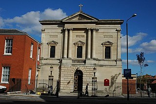
St George's Church is a Roman Catholic Parish church in Worcester. It was founded in 1829 and was administered by the Society of Jesus until 1990 when it was handed over to the Archdiocese of Birmingham. It is in the Baroque style, is a Grade II* listed building and was where Edward Elgar was organist from 1885.

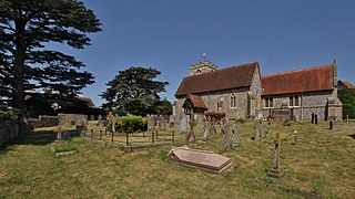
St Wulstan's Roman Catholic Church, Little Malvern, Worcestershire, England is a Benedictine parish church administered by the monks of Downside Abbey. The attached churchyard contains the grave of the composer Edward Elgar and of his wife, Alice. The church was designed in 1862 in a Gothic Revival style by Benjamin Bucknall. It is a Grade II listed building. The Elgars' grave has a separate Grade II listing.

