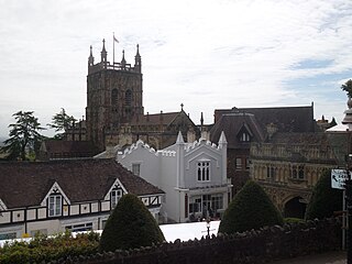
Malvern is a spa town and civil parish in Worcestershire, England. It lies at the foot of the Malvern Hills, a designated Area of Outstanding Natural Beauty. The centre of Malvern, Great Malvern, is a historic conservation area, which grew dramatically in Victorian times due to the natural mineral water springs in the vicinity, including Malvern Water.
Malvern Hills is a local government district in Worcestershire, England. Its council is based in the town of Malvern, and its area covers most of the western half of the county, including the outlying towns of Tenbury Wells and Upton-upon-Severn. It was originally formed in 1974 and was subject to a significant boundary reform in 1998. In the 2011 census the population of the Malvern Hills district was 74,631.
Earl Beauchamp was a title in the Peerage of the United Kingdom.

Shelsley Walsh is a small village and civil parish in Worcestershire, England, on the western side of the River Teme. For administrative purposes it is presently located in the Teme Valley ward of the county’s Malvern Hills district. In the 2011 Census there was an estimated population of 28 people in 12 households. The site has been farmed since Anglo Saxon times and there are also vestiges of former industry, but it is now best known for its association with the Shelsley Walsh Speed Hill Climb.

Kempsey is a village and civil parish in the Malvern Hills District in the county of Worcestershire, England. It is bounded by the River Severn on the west, and the A38 main road runs through it and is about 3 miles (5 km) south of Worcester. The village has a long history. Its name is derived from the Saxon "Kemys' Eye", or the island of Kemys. Kemys was a Saxon chief, whose island lay between marshes and the River Severn. One of the roads in Kempsey, Lyf's Lane, is named after another Saxon chief. The village was recorded in the 11th century Domesday Book as having a value of £7.
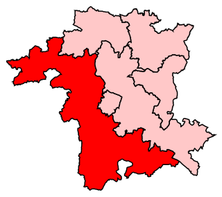
West Worcestershire is a constituency in Worcestershire represented in the House of Commons of the UK Parliament since 2010 by Harriett Baldwin, a Conservative. The constituency is considered a safe seat for the Conservatives. The constituency boundaries roughly correspond with the Malvern Hills District.

Colwall is a civil parish in Herefordshire, England, situated on the border with Worcestershire, nestling on the western side of the Malvern Hills at the heart of the AONB. Areas of the village are known as Colwall Stone, Upper Colwall which shares a common border at the Wyche Cutting with the Malvern suburb of Malvern Wells, and Colwall Green, spread along 2 miles (3.2 km) of the B4218 road, with the historic village core being 1 mile (1.6 km) to the west of Colwall Stone.

Martley is a village and civil parish in the Malvern Hills district of the English county of Worcestershire. It is approximately nine miles north-west of Worcester. The population of the village is approximately 1,200 people. The mixed farming of the area includes arable, formerly cherry, apple, damson orchards and hopyards.
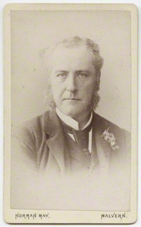
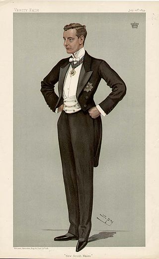
Frederick Lygon, 6th Earl Beauchamp PC DL, styled The Honourable Frederick Lygon between 1853 and 1866, was a British Conservative politician.

Guarlford is a village and civil parish in the Malvern Hills district in the county of Worcestershire, England. The parish population was 261 in 2021.
Beoley is a small village and larger civil parish north of Redditch in the Bromsgrove District of Worcestershire. It adjoins Warwickshire to the east. The 2021 census gave a parish population of 984, mostly at Holt End. The parish includes the hamlet of Portway, adjacent to the A435 road. It adjoins the Redditch suburb of Church Hill and the civil parishes of Alvechurch, Tanworth-in-Arden, Mappleborough Green and Wythall.

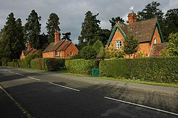
Newland is a village and civil parish on the north-eastern edge of Malvern Link, Worcestershire, England, on the A449 road.

Madresfield Court is a country house in Malvern, Worcestershire, England. The home of the Lygon family for nearly six centuries, it has never been sold and has passed only by inheritance since the 12th century; a line of unbroken family ownership reputedly exceeded in length in England only by homes owned by the British Royal Family. The present building is largely a Victorian reconstruction, although the origins of the present house are from the 16th century, and the site has been occupied since Anglo-Saxon times. The novelist Evelyn Waugh was a frequent visitor to the house and based the family of Marchmain, who are central to his novel Brideshead Revisited, on the Lygons. Surrounded by a moat, the Court is a Grade I listed building.
Callow End is a constituent village of the civil parish of Powick in the Malvern Hills District of Worcestershire, England. It is located on the B4424 road about 1 mile (1.6 km) to the south of its junction with the main A449 Malvern to Worcester road. The River Severn runs down the eastern side of the village.

Croome D'Abitot is a village and civil parish, which shares a joint parish council with Severn Stoke, in the Malvern Hills District in the county of Worcestershire, England. The parish church of St Mary Magdalene is situated in the grounds of Croome Court.
Among the places of worship in the town and area of Malvern, Worcestershire are centres of dedication to many faiths and denominations. The town has 31 Christian churches with 11 belonging to the Church of England, ranging from low church to high Anglo-Catholic, two Roman Catholic, one Evangelical, and the others being Non-Conformist and other faiths. Its oldest place of worship is the almost cathedral sized parish church of Great Malvern Priory which is all that remains of the former 10th century abbey in central Malvern, which according to the Worcester Monastic Annals, work began in 1085. The chain of Malvern Hills lies in a north-south direction, thus posing a challenge for the architects of Christian churches located on the steep slopes, chancels being traditionally sited at the east end of the building. Many churches were built in the 19th century concomitant with the rapid expansion of the town due to its popularity as a spa. A few modern buildings such as St Mary's Church (1960) in Sherrard's Green, have been constructed in the second half of the 20th century, and some churches, notably St Andrews in Poolbrook, have had important modern extensions added during the first decade of the 21st century.
William Beauchamp Lygon, 2nd Earl Beauchamp FRS, styled The Honourable William Lygon between 1806 and 1815 and Viscount Elmley between 1815 and 1816, was a British politician.
Salwarpe is a small village and civil parish in the Wychavon district of Worcestershire, England, less than two miles south west of Droitwich, but in open country. The name is also spelled Salwarp, and in the time of John Leland was recorded as Salop. Since 2003, Salwarpe has shared a parish council with Hindlip and Martin Hussingtree.

Shelsley Beauchamp or Great Shelsley is a village and civil parish 9 miles (14 km) north west of Worcester, in the Malvern Hills district, in the county of Worcestershire, England. In 2011 the parish had a population of 192. It is on the opposite bank of the River Teme to Shelsley Walsh. The parish touches Clifton upon Teme, Great Witley, Martley, Shelsley Kings and Shelsley Walsh. It shares a parish council with Shelsley Kings and Shelsley Walsh called the Shelsley Parish Council.