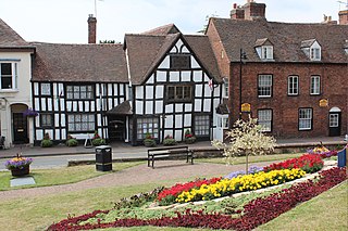
Upton-upon-Severn is a town and civil parish in the Malvern Hills District of Worcestershire, England. Lying on the A4104, the 2021 census recorded a population of 2,903 for the town.
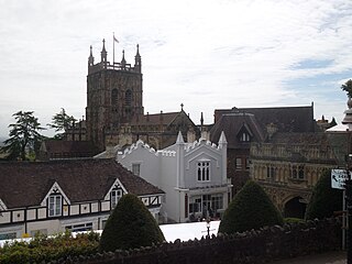
Malvern Hills is a local government district in Worcestershire, England. Its council is based in Malvern, the district's largest town. The district also includes the towns of Tenbury Wells and Upton-upon-Severn and a large rural area covering much of the western side of the county, including numerous villages. The district is named after the Malvern Hills, which are a designated Area of Outstanding Natural Beauty.

Abberley is a village and civil parish in north west Worcestershire, England.

Malvern Link is an area in the civil parish of Malvern, in the Malvern Hills District, in Worcestershire, England to the north and east of Great Malvern. The centres of Malvern Link and Great Malvern are separated by Link Common, an area of open land that is statutorily protected by the Malvern Hills Conservators. The population of Link in 2011 was 6,155.

Barnards Green is one of the main population areas of Malvern, Worcestershire, England, situated approximately 1 mile (1.6 km) east and downhill from Great Malvern, the town's traditional centre.

The Cotswold Line is an 86+1⁄2-mile (139.2 km) railway line between Oxford and Hereford in England.

Leigh is a village and civil parish in the Malvern Hills district of the county of Worcestershire, England.

Powick is a village and civil parish in the Malvern Hills district of Worcestershire, England, located two miles south of the city of Worcester and four miles north of Great Malvern. The parish includes the village of Callow End and the hamlets of Bastonford, Clevelode, Collett's Green, and Deblins Green.

Newland is a village and civil parish on the north-eastern edge of Malvern Link, Worcestershire, England, on the A449 road.
Noah's Ark is a British television series about a country vet and his family, aired on ITV. The first series of six episodes was broadcast in September to October 1997. A second series, also of six episodes, aired a year later.

Cotheridge is a village and civil parish in the district of Malvern Hills in the county of Worcestershire, England. It is 4 miles (6 km) west of the city of Worcester and a mile north-east of the Leigh Court railway station on the Great Western Railway on the opposite side of the River Teme.
The River Teme flows on the southern and south-western part of the village where the land is low-lying and is susceptible to flooding. The soil content is loam and clay with the subsoil being Keuper Marl.

Welland is a village and civil parish in the administrative district of Malvern Hills in the county of Worcestershire, England. It has a combined parish council with Little Malvern, with 9 of the 11 councillors. It is about 6 miles (9.7 km) from the town of Malvern, 15 miles from the city of Worcester, and 18 miles from the city of Gloucester. It is surrounded by farms and common land, and is part of the informal region referred to as The Malverns.

Grimley is a village and civil parish in the Malvern Hills District in the county of Worcestershire, England about 3 miles (4.8 km) north of Worcester. It is known for the Norman Parish Church; St Bartholome, and nature reserve SSSI.

Bransford is a village and civil parish in the Malvern Hills district of the county of Worcestershire, England. It is situated close to the River Teme and the village of Leigh. It is on the primary route between Worcester and Hereford, the A4103 that runs through the centre of the village. According to the 2021 census, Bransford has a population of 527. The parish shares its parish council with Leigh.
Callow End is a constituent village of the civil parish of Powick in the Malvern Hills District of Worcestershire, England. It is located on the B4424 road about 1 mile (1.6 km) to the south of its junction with the main A449 Malvern to Worcester road. The River Severn runs down the eastern side of the village.
Leigh and Bransford are two separate civil parishes in the district of Malvern Hills of the county of Worcestershire, England, with a single parish council. Situated about 5 miles (8.0 km) from Worcester and 5 miles (8.0 km) from Malvern, in addition to the villages of Leigh Sinton, Leigh and Bransford, the combined parishes also include the hamlets of Brockamin, Sandin, and Smith End.

Poolbrook is a village and a suburb of Malvern, Worcestershire, England, situated approximately 1.5 miles (2.4 km) southeast of Great Malvern, the town's centre, and about 0.5 miles (08 km) from the Malvern suburb of Barnards Green on the Poolbrook Road (B4208). The village comprises several shops, a traditional English pub, and a number of council and private housing estates. St Andrew's C of E parish church was built in Early English style in 1882 as a memorial to a member of the Chance Brothers glass manufacturing family. The village occupies the geographical centre of the Chase ward of Malvern Town Council.

