Llandaff is a district, community and coterminous electoral ward in the north of Cardiff, capital of Wales. It was incorporated into the city in 1922. It is the seat of the Bishop of Llandaff, whose diocese within the Church in Wales covers the most populous area of Wales.
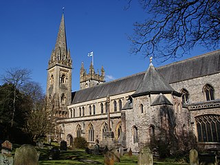
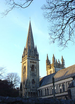
Llandaff Cathedral is an Anglican cathedral and parish church in Llandaff, Cardiff, Wales. It is the seat of the Bishop of Llandaff, head of the Church in Wales Diocese of Llandaff. It is dedicated to Saint Peter and Saint Paul, and three Welsh saints: Dubricius, Teilo and Oudoceus. It is one of two cathedrals in Cardiff, the other being the Roman Catholic Cardiff Metropolitan Cathedral in the city centre.

The Diocese of Llandaff is an Anglican diocese that traces its roots to pre-Reformation times as heir of a Catholic bishopric. It is headed by the Bishop of Llandaff, whose seat is located at the Cathedral Church of Saint Peter and Saint Paul in Llandaff, a suburb of Cardiff. It currently covers most of the former Welsh county of Glamorgan, but once stretched from the River Towy to the middle of the Wye Valley.

Lamphey is both a village, a parish and a community near the south coast of Pembrokeshire, Wales, approximately 2 miles (3.2 km) east of the town of Pembroke, and 2 miles (3.2 km) north of the seaside village of Freshwater East. The 2011 census reported a population of 843.

Llanvaches or Llanfaches is a village and community parish within the boundaries of the city of Newport, Wales. It lies to the east of the urban area, in the historic county of Monmouthshire and the preserved county of Gwent. The population rose to 402 by the 2011 census.

Langstone is a community and village of the city of Newport, Wales. The area is governed by the Newport City Council. The community had a population of 3,279 in 2011.
Goldcliff is a village, parish and community to the south east of the city of Newport in South Wales. It lies within the Newport city boundaries in the historic county of Monmouthshire and the preserved county of Gwent. Administratively, the community of Goldcliff includes the village/parish of Whitson. The population in 2001 was 233; by 2011 it had risen to 329.
Penhow is a small village and community (parish) just inside the eastern edge of the boundary of the city of Newport, South Wales, within the historic county of Monmouthshire. The name Penhow is believed to be derived from the Welsh word Pen meaning head or top and How derived from the Old Norse word Haugr meaning hill or mound. The community includes the estate of Parc Seymour.

Redwick is a small village and community (parish) to the south east of the city of Newport, in Wales, United Kingdom. It lies within the Newport city boundaries, in the historic county of Monmouthshire and the preserved county of Gwent. in 2011 the population was 206.
Mathern is a historic community (parish) and village in Monmouthshire, south east Wales, about 3 miles (4.8 km) south west of the town of Chepstow, close to the Severn estuary, the Bristol Channel and the M48 motorway. The village is designated as a Conservation Area. It is now bisected by the motorway, which passes over the road through the village, with the original village located to the south and the more recent development, known as Newton Green, to the north.
Nash is a village and community to the south of the city of Newport, South Wales, in the Lliswerry ward.

Llangadwaladr is a small village in south-west Anglesey, Wales, located around 2 miles east of Aberffraw and 3 miles south of Gwalchmai. It is part of the community of Bodorgan.

The Church of St Mary stands in the centre of the village of Magor, Monmouthshire, Wales. It was designated a Grade I listed building in 1963. The church is the lead church of the Netherwent Ministry Area, led by Rev. Canon Jeremy Harris, and administers to a population of around 32,000.

Mathern Palace is a Grade I listed building in the village of Mathern, Monmouthshire, Wales, located some 3 miles (4.8 km) south-west of Chepstow close to the Severn Estuary. Between about 1408 and 1705 it was the main residence of the Bishops of Llandaff. After falling into ruin, it was restored and its gardens laid out between 1894 and 1899 by the architectural writer Henry Avray Tipping. The garden surrounding the palace is listed on the Cadw/ICOMOS Register of Parks and Gardens of Special Historic Interest in Wales.

The Bishop's Palace, which is also known as Llandaff Castle or Bishop's Castle or the Old Bishop's Palace, is the ruined residence of the bishops of Llandaff. It is located a short distance to the south of Llandaff Cathedral in Cardiff, Wales. The twin-towered gatehouse is one of the few remaining structures.

Moynes Court is a Grade II* listed building in the village of Mathern, Monmouthshire, Wales, about 3 miles (4.8 km) south west of Chepstow. An earlier building was rebuilt as a private residence by Francis Godwin, Bishop of Llandaff, in about 1609/10, and much of the building remains from that period. Its grounds contain earthworks thought to be the foundations of an earlier moated manor house. The gatehouse to the court has a separate Grade II* listing. The garden at the court is on the Cadw/ICOMOS Register of Parks and Gardens of Special Historic Interest in Wales.

St Peter's Church is the Church in Wales parish church for the town of Carmarthen, Wales. Though founded much earlier, the present building dates from at least the 14th century. It is the largest church in the Diocese of St David's and is a Grade I listed building. It is also the oldest surviving building in Carmarthen.
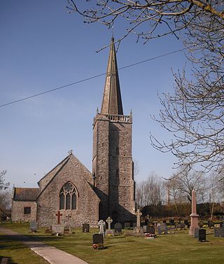
St Tewdric's Church is a Church in Wales parish church in Mathern, Monmouthshire, Wales. It is purportedly built over the resting place of Saint Tewdrig for whom it is named. A church has been located on the site since the 6th century. It was reconstructed by the Normans in the Early English style, and later was renovated by the Victorians. It is a Grade I listed building.
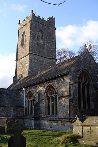
St Cadwaladr's Church is a Grade I listed church in Llangadwaladr, Anglesey. The location of the current church was established in the 7th century by the Kings of Gwynedd, after whom the church is named, King Cadwaladr. The Church standing today was built in the 'T' shape perpendicular style. The nave is dated to the 12th to early 13th century and the chancel to the 14th. Later the chapels were built, the north in 1640 and the southern Bodowen Chapel in 1661. Then, during 1856 the church underwent restoration, at which time to south porch was added.
Llanwern is the name of an electoral ward for Newport City Council in south Wales. It covers several rural communities to the east of the city. It is represented by one city councillor.


