Nash, Newport

Last updated

Nash
Village and community
St Marys Nash.jpg
Newport UK location map.svg
Red pog.svg
Nash
Location within Newport
Population284 (2011 census [1] )
Principal area
Preserved county
Country Wales
Sovereign state United Kingdom
Post town NEWPORT
Postcode district NP18
Postcode district NP19
Dialling code 01633
Maindee exchange
Police Gwent
Fire South Wales
Ambulance Welsh
UK Parliament
Senedd Cymru – Welsh Parliament
List of places
UK
Wales
Newport
51°32′56″N2°56′46″W / 51.548917°N 2.946175°W / 51.548917; -2.946175
Historical population
YearPop.±%
2001 281    
2011 284+1.1%
Source: 2001 and 2011 Censuses [2]
Sheep, in the shade of a tree, beside a reen Sheep beside a reen - geograph.org.uk - 566470.jpg
Sheep, in the shade of a tree, beside a reen

Nash (Welsh : Trefonnen) is a village and community to the south of the city of Newport, South Wales, in the Lliswerry ward. [3]

Contents

Origin of the name

The name is thought to originate from a contraction of "An Ash" (tree), meaning literally `place of the ash tree(s)'. This is supported by its appearance in deeds as "De Fraxino" ( fraxinus was the Latin name for the ash tree). [4] The Welsh name is Trefonnen, given in older sources as Tre'r onnen, also meaning Town (tref) of the Ash (onnen).

Nash and nearby Goldcliff, as Nash and Goldcliffe, are two of the few villages to appear on the Cambriae Typus map of 1573. [5]

Location

Nash lies about 1 mile (1.6 km) to the south of the built-up area of the city of Newport, on the Caldicot levels, a large area of land reclaimed from the sea and crossed by drainage channels and reens. [6] In addition to the village itself, the parish contains Uskmouth power stations [7] and part of the Newport Wetlands nature reserve, [8] including its Visitors Centre which was opened in 2008. [9]

The City of Newport campus of Coleg Gwent (commonly referred to as 'Nash College') is actually in the neighbouring parish of Lliswerry.

Together with the neighbouring parishes of Goldcliff and Whitson, Nash is one of the "Three Parishes" which have long been treated as a unit – geographical, socially, economically and ecclesiastically.

The parish is bounded to the south by the sea (Bristol Channel) to the east by the lower reaches of the River Usk and to the north by Lliswerry and the Llanwern Steelworks site. To the east lie Goldcliff and Whitson.

History

In 1901 the only four private residents are listed as Mrs Morgan at "Greenfield", Mrs Morgan at "The Elms", Rev. C. W. Triton (Baptist minister, but curiously no separate residence given) and Miss Ester Wilcox at "Decoy Pool". Some twenty nine commercial interests include mostly farmers (22) but also William German, blacksmith and wheelwright, at "Pye Corner", Mrs Sarah Jones, publican at "Waterloo Inn", John Skuse, shop-keeper at Broadstreet Common, Edward Tamplin butcher at "Box Cottage", David Thomas farm bailiff to Mr. James Thomas at "Pye Corner Farm", John Watkins, butcher and Lewis Williams, mason at "Ash Cottage". [10]

Fair Orchard Fair Orchard, Nash - geograph.org.uk - 1778114.jpg
Fair Orchard

A large part of the village, including Farmfield House, was lost in the construction of the Uskmouth power station and the adjoining huge ash-pits in 1959. Although the main part of the village centres around the church in West Nash, much of the village is set along the wide Broadstreet Common, accessed via Pye Corner or Straits Lane, and which provides the more direct route to Whitson and Redwick. For many years the German family were the village blacksmiths at Pye Corner with the premises eventually becoming a petrol station. The site is now occupied by the offices of the Caldicot and Wentloog Levels Internal Drainage Board. [11] About 400 metres (440 yd) south of Pye Corner is Fair Orchard, dating from the early 19th century, which is a Grade II listed building. [12] The village had its own small infant school, built in 1877 [10] on West Nash Road. It closed in the early 1980s and has now been converted into a private dwelling.

The Church

The Church of St Mary in West Nash dates from the 12th century. [13] Known as "the Cathedral of the Moors", it is notable for its fine tower and spire. The church belonged to Goldcliff Priory in 1349 when the benefice was held by Robert Arney. Later members of the Arney family left a cottage and six acres of land, called "The Poor's Six Acres", for the support of the poor of the parish. [14] The church was largely rebuilt during the 16th century. [15]

The only remains of the Norman church are the north wall of the chancel and the squint. An unusual feature, the squint or hagioscope was used to enable those with leprosy, smallpox or other such diseases, to see or participate in the service without endangering the rest of the congregation with infection. The tower is unusually located on the north side of the chancel. The church is thought to originally have been much larger, incorporating a north aisle. [14] In the 20th century the bellringer's room was used as a temporary mortuary for the bodies of five sailors who had drowned in a storm, near the East Usk Lighthouse. During World War II the church saw congregations of 400. [14] The interior, following restoration in 2004–2005, is notable for its complete set of 18th century furnishings, with box pews, a three-decker pulpit and a western gallery. In the fields to the south of the neighbouring Church Farm are ancient tumuli, remnants of a, possibly mediæval, dwelling or chapel.

Baptist chapel

Former Baptist Chapel, Pye Corner Former Nash Baptist Chapel, Pye Corner - geograph.org.uk - 1586375.jpg
Former Baptist Chapel, Pye Corner

At Pye Corner is the former Baptist chapel. The chapel, which opened in 1820 or 1822, [16] had seating for 125 and a congregation which included residents of what was then the hamlet of Lliswerry, about 1 mile (1.6 km) to the north. When Lliswerry Baptist Church opened in 1889 some of the Pye Corner congregation transferred their allegiance there. The same year that Lliswerry was incorporated into Newport under the provisions of the Newport (Mon.) Corporation Act, 1889. A steady decline in attendances at Nash led to only five remaining members in 1988 and the chapel closed shortly afterwards. It was later converted to a private house. [17] [18]

Amenities

Ophrys apifera at Newport Wetlands Reserve Orchid at Newport Wetlands (4) - geograph.org.uk - 1366553.jpg
Ophrys apifera at Newport Wetlands Reserve

To the north of church, at the end of St. Mary's Road, The Waterloo public house is a tenanted free-house notable for the fact it is owned by the parish council. A modern Community Hall has been built nearby.

Located at the edge of the Newport Wetlands Reserve, [19] East Usk Lighthouse [20] provides a notable landmark. Parts of Nash are designated a Site of Special Scientific Interest SSSI. [21]

The village enjoys a regular public bus service provided by Crossgates Coaches. The local newspaper is the South Wales Argus which is published in Newport.

In October 2009 the village skyline was transformed with the installation of two 2.5-megawatt wind turbines, on the site of chemical company Solutia UK Ltd, which will supply up to one-third of the facility's electricity needs. [22]

Present-day Nash

Entrance to Newport Wetlands Visitor Centre Entrance to Newport Wetlands Visitor Centre - geograph.org.uk - 729101.jpg
Entrance to Newport Wetlands Visitor Centre

Several road schemes have proposed a southern relief motorway loop for Newport, as a way of mitigating the congestion of the existing M4 motorway. Many of these schemes have involved intrusion, to a greater or lesser extent, into Nash. As a result Nash Community Council became a member of the "Campaign Against the Levels Motorway" (CALM) Alliance formed to oppose such schemes by the Friends of the Earth Cymru. [23] The bypass scheme was eventually cancelled in July 2009. [24]

In June 2010 a public meeting was held at the village Community Centre to discuss proposals for a waste incinerator in Newport. Members of the "Stop Newport Incinerator Campaign (SNIC)" organised the meeting to explain to residents the possible development on Bowleaze Common land south of Llanwern steelworks. [25]

Government

The area is governed by the Newport City Council and the Nash, Newport community council. The village falls within the Llanwern ward of the Newport East parliamentary constituency.

Related Research Articles

<span class="mw-page-title-main">Newport, Wales</span> City and County Borough in Wales

Newport is a city and county borough in Wales, situated on the River Usk close to its confluence with the Severn Estuary, 12 mi (19 km) northeast of Cardiff. With a population of 145,700 at the 2011 census, Newport is the third-largest principal authority with city status in Wales, and seventh most populous overall. Newport became a unitary authority in 1996 and forms part of the Cardiff-Newport metropolitan area, also known as the Cardiff Capital Region. Newport was the site of the last large-scale armed insurrection in Great Britain, the Newport Rising of 1839. The population grew considerably between the 2011 and the 2021 census, rising to 159,587, the largest growth of any unitary authority in Wales.

<span class="mw-page-title-main">Monmouthshire</span> County in Wales

Monmouthshire is a county in the south east of Wales. It borders Powys to the north; the English counties of Herefordshire and Gloucestershire to the north and east; the Severn Estuary to the south, and Torfaen, Newport and Blaenau Gwent to the west. The largest town is Abergavenny, and the administrative centre is Usk.

<span class="mw-page-title-main">Caldicot</span> Town in Wales

Caldicot is a market town and community in Monmouthshire, Wales. The town is located between Chepstow and the city of Newport. The site adjoins the Caldicot Levels, on the north side of the Severn Estuary. The population of the built-up area was around 11,000. It has a large school, Caldicot School, and is known for its medieval castle. The built-up area includes Portskewett. Caldicot had a population of 9,604 in 2011.

Uskmouth is an area to the south of the city of Newport, South Wales.

<span class="mw-page-title-main">Rogiet</span> Human settlement in Wales

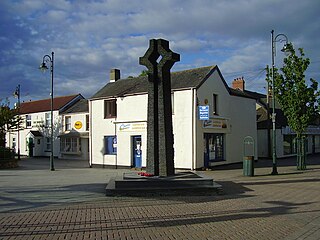
Rogiet is a small village and community in Monmouthshire, south east Wales, between Caldicot and Magor, 8 miles (13 km) west of Chepstow and 11 miles (18 km) east of Newport, which covers an area of 847 hectares (3.27 sq mi). It lies close to the M4 and M48 motorways, and the Second Severn Crossing. It has a railway station named Severn Tunnel Junction. Rogiet only has a population of 1,813 (2011).

<span class="mw-page-title-main">Lliswerry</span> Human settlement in Wales

Lliswerry, or Liswerry is an electoral district (ward) and community of the city of Newport, South Wales. The area is governed by Newport City Council. It is the largest community/ward in the city.

<span class="mw-page-title-main">Caldicot Hundred</span>

Caldicot was an ancient hundred of Monmouthshire, Wales.

<span class="mw-page-title-main">Whitson</span> Human settlement in Wales

Whitson is a village on the outskirts of the city of Newport, South Wales. It is located about 7 miles (11 km) south east of Newport city centre on the Caldicot Levels, a large area of coastal land reclaimed from the sea. Administratively, Whitson is part of the community of Goldcliff.

<span class="mw-page-title-main">Langstone, Newport</span> Human settlement in Wales

Langstone is a community and village of the city of Newport, Wales. The area is governed by the Newport City Council. The community had a population of 3,279 in 2011.

<span class="mw-page-title-main">Llanwern</span> Community in Wales

Llanwern is a community in the eastern part of the City of Newport, South East Wales. Llanwern is bounded by the M4 and Langstone to the north, Ringland, Lliswerry and the River Usk to the west, the River Severn to the south and the city boundary to the east. The population of the Llanwern community in 2011 was 333, which contains Llanwern village and the western half of the site of Llanwern steelworks. The area is governed by the Newport City Council. The community population dropped to 289 in 2011. The community also includes the area of Glan Llyn.

Newport Poor Law Union was a health and social security organisation in Newport, Monmouthshire and surrounding parishes. It was formed on 1 August 1836 under the Poor Law Amendment Act 1834 and was composed of 40 constituent parishes:

<span class="mw-page-title-main">Goldcliff, Newport</span> Village in the city of Newport, South Wales

Goldcliff is a village, parish and community to the south east of the city of Newport in South Wales. It lies within the Newport city boundaries in the historic county of Monmouthshire and the preserved county of Gwent. Administratively, the community of Goldcliff includes the village/parish of Whitson. The population in 2001 was 233; by 2011 it had risen to 329.

<span class="mw-page-title-main">Redwick, Newport</span> Human settlement in Wales

Redwick is a small village and community (parish) to the south east of the city of Newport, in Wales, United Kingdom. It lies within the Newport city boundaries, in the historic county of Monmouthshire and the preserved county of Gwent. in 2011 the population was 206.

<span class="mw-page-title-main">Caldicot and Wentloog Levels</span> Coastal plain and wetlands in Monmouthshire, Wales

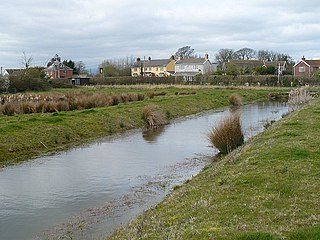
The Caldicot and Wentloog Levels are two areas of low-lying estuarine alluvial wetland and intertidal mudflats adjoining the north bank of the Severn Estuary, either side of the River Usk estuary near Newport in south east Wales. They are also known collectively as the Monmouthshire Levels or Gwent Levels, and the name Wentloog is sometimes spelled Wentlooge in official publications.

Magor and St Mellons Rural District was created on 1 April 1935 from Magor Rural District and St Mellons Rural District in the administrative county of Monmouthshire. The district was a mixture of suburban and semi-rural parishes around Newport and had its headquarters in Baneswell, Newport.

Southern Monmouthshire was a parliamentary constituency in Monmouthshire. It returned one Member of Parliament (MP) to the House of Commons of the Parliament of the United Kingdom.

<span class="mw-page-title-main">Llangwm, Monmouthshire</span> Human settlement in Wales

Llangwm is a small rural village and former community, now in the community of Llantrisant Fawr, in Monmouthshire, south east Wales. It is located 3 miles (4.8 km) east of Usk, on the B4235 Chepstow to Usk road. The main village is at Llangwm Uchaf, with a smaller and more dispersed settlement about 1 mile (1.6 km) to the north-east at Llangwm Isaf .The other settlement in the community is Llansoy. In 2022 the community was abolished and merged with Llantrisant Fawr.

<span class="mw-page-title-main">Newport Wetlands</span> Lighthouse

Newport Wetlands is a wildlife reserve covering parts of Uskmouth, Nash and Goldcliff, in the south-east of the city of Newport, South Wales.

Llanwern is the name of an electoral ward for Newport City Council in south Wales. It covers several rural communities to the east of the city. It is represented by one city councillor.

References

  1. Sillitoe, Neighbourhood Statistics - Neil (14 April 2008). "Detect browser settings". neighbourhood.statistics.gov.uk. Retrieved 5 March 2017.
  2. "Neighbourhood Statistics - Census". Office of National Statistics (Census). 14 April 2008. Retrieved 3 March 2017.
  3. "Councillors". democracy.newport.gov.uk. 5 March 2017. Retrieved 5 March 2017.
  4. Bradney, Sir Joseph, A History of Monmouthshire, Vol 4 part 2: The Hundred of Caldicot (Part 2). pub 1914, reprinted 1994, Merton Priory Press.
  5. A reproduction of the map is at File:Atlas_Ortelius_KB_PPN369376781-011av-011br.jpg
  6. "Geograph:: Reen near Nash, Newport (C) Robin Drayton". geograph.org.uk. Retrieved 5 March 2017.
  7. "Geograph:: Uskmouth powerstation (C) Mrs Blorenge". geograph.org.uk/. Retrieved 5 March 2017.
  8. "Geograph:: Newport Wetlands Visitor Centre (C) Robin Drayton". geograph.org.uk/. Retrieved 5 March 2017.
  9. Newport centre is a wetland wonder!
  10. 1 2 "Kelly's Directory for Monmouthshire, 1901". freepages.genealogy.rootsweb.com. Retrieved 5 March 2017.
  11. "Caldicot and Wentloog Drainage Board". cwidb.co.uk. Archived from the original on 28 September 2007. Retrieved 5 March 2017.
  12. Good Stuff (31 October 1996). "Fair Orchard – Nash – Newport – Wales". British Listed Buildings. Retrieved 22 February 2016.
  13. "900-year-old Newport church to tell its story". southwalesargus.co.uk/news. Retrieved 5 March 2017.
  14. 1 2 3 Hando, F.J., (1958) "Out and About in Monmouthshire", R. H. Johns, Newport.
  15. "900-year-old Newport church to tell its story", South Wales Argus, 6 August 2010. Retrieved 22 January 2014.
  16. "Baptist Chapel, Pye Corner, (10895)". Coflein. RCAHMW . Retrieved 5 March 2017.
  17. "Nash Baptist Church, Nash, Newport". Archived from the original on 25 September 2006. Retrieved 4 February 2007.
  18. "Geograph:: Former Nash Baptist Chapel, Pye Corner (C) Jaggery". geograph.org.uk. Retrieved 5 March 2017.
  19. "Geograph:: Newport Wetlands Plaque (C) Robin Drayton". geograph.org.uk. Retrieved 5 March 2017.
  20. "Geograph:: Newport Wetlands, East Usk Lighthouse (C) Robin Drayton". geograph.org.uk. Retrieved 5 March 2017.
  21. "Biodiversity - Newport City Council". newport.gov.uk. Retrieved 5 March 2017.
  22. Blake, Aled (31 October 2009). "Solutia in green bid to blow away high energy bills". walesonline.co.uk. Retrieved 5 March 2017.
  23. "Friends of the Earth Cymru". foe.co.uk. Retrieved 5 March 2017.
  24. "CBRD » Error 404: Document Not Found". cbrd.co.uk. Archived from the original on 14 August 2014. Retrieved 5 March 2017.
  25. "Incinerator plans up for discussion". southwalesargus.co.uk. Retrieved 5 March 2017.

This article contains public domain material from J. A. Bradney's History of Monmouthshire (1904).