Black Mountain (range)

Last updated

Fan Brycheiniog the highest peak on the Black Mountain Bannaubrych.JPG
Fan Brycheiniog the highest peak on the Black Mountain

The Black Mountain (Welsh : Y Mynydd Du) is a mountain range in South, Mid and West Wales, straddling the administrative boundary between Carmarthenshire and Powys (as well as the county boundary between Carmarthenshire and Brecknockshire) and forming the westernmost range of the Brecon Beacons National Park. Its highest point is Fan Brycheiniog at 802 metres or 2,631 ft. The Black Mountain also forms a part of the Fforest Fawr Geopark. [1]

Contents

Name

The Black Mountain should not be confused with the Black Mountains in the east of the National Park, nor with a 703 metres (2,306 ft) summit in the Black Mountains that is confusingly also called Black Mountain. In his description of a Blak Montayne, the antiquarian John Leland refers to a massif extending between Carmarthen and Monmouth i.e. what is now considered to be the Brecon Beacons in the wider modern sense of that term, thus also including the Black Mountains and the intervening high ground of Fforest Fawr. [2] [3]

The term "Carmarthen Fans" (Bannau Sir Gâr in Welsh) is sometimes used inaccurately to describe the whole of this massif, whereas it should be restricted to the peaks along the northern escarpment within Carmarthenshire (the peak of Fan Brycheiniog lies east across the border into Brecknockshire). The "Carmarthen Fans" thus includes Fan Foel, Picws Du and Waun Lefrith. The highest point of the "Carmarthen Fans" and the county top of Carmarthenshire is thus the minor summit of Fan Foel, height 781 metres (2,562 ft).

Geology

The range stretches approximately from Ammanford in the south-west to Sennybridge in the north-east. The larger part of these hills is formed from Old Red Sandstone, though bands of Carboniferous Limestone and of Twrch Sandstone (or Millstone Grit) are important landscape-forming rocks in the south and west of the range owing to their greater resistance to erosion. The most resistant of all are the Plateau beds, which form a protective cap over most of the range. They also form steep cliffs just below the edge of the escarpment. The rocks are of the Devonian, in common with their companion peaks of the Brecon Beacons to the east. The area was glaciated during the ice ages and a number of fresh moraines are to be found beneath the spectacular north and east facing sandstone scarps in the north-east of the range, especially below Fan Hir. There are smaller moraines lying immediately below the cliffs of Waun Lefrith and Picws Du.

Llyn y Fan Fawr, below Fan Brycheiniog in the Black Mountain Llyn y Fan Fawr.jpg
Llyn y Fan Fawr, below Fan Brycheiniog in the Black Mountain

The lakes below the escarpment of Llyn y Fan Fawr and Llyn y Fan Fach are also remnants of glacial action, having been created by other moraines blocking drainage by forming deep hollows below the cliffs.

Archaeology

There are many surviving remains, especially prehistoric and Roman, in the area. They include the castra s at Mynydd Bach Trecastell and a Roman road crossing Fforest Fawr as Sarn Helen. There are numerous menhirs, round barrows and several small stone circles. An especially famous circle occurs on the banks of the River Tawe below Fan Hir, and is known as Cerrig Duon, or "black stones". There is a standing stone outside the circle nearby, known as Maen Mawr, with two smaller stones forming a small avenue. There is also evidence of human settlements, hut circles and agriculture. Recent excavation of a cairn or round barrow on Fan Foel showed it to be of early Bronze Age in date (circa 2000 BC) and there is a very similar unexcavated round barrow on Picws Du. The excavation at Fan Foel indicated that the moorland was well-wooded in Bronze Age Britain owing to a warmer climate than at present, with much of the present moorland covered by hazel scrub with oak at lower heights. Most current moorland elsewhere in Britain was in a similar condition, and extensive Bronze Age remains have been found there too. Examples include Dartmoor, Exmoor, Bodmin Moor, much of the upland Pennines and upland Welsh moorland in the centre and north of the country. All such moorlands are tree-less in their upper parts, in their current sub-arctic state.

Drainage

Llyn y Fan Fach lake below the escarpment and Picws Du Llyn y Fan Fach (1323880314).jpg
Llyn y Fan Fach lake below the escarpment and Picws Du
The Black Mountain range seen from the Usk Reservoir Usk reservoir with Black Mountain peaks - geograph.org.uk - 540508.jpg
The Black Mountain range seen from the Usk Reservoir

The massif is drained by a number of rivers which flow down the southern dip-slopes of the massif from its main ridge. In contrast the northerly directed streams tend to be shorter and steeper. The upper parts of the range are largely moorland and covered with peat bog, some of which is degrading judging by the partly destroyed sections of peat bank near Llyn y Fan Fawr. The rivers Usk and Tawe have their sources on the northern and eastern flanks of the range whilst the smaller Loughor arises at the western end of the range. Significant right bank tributaries of the Tawe such as the River Giedd and the Afon Twrch, as well as the River Amman, a tributary of the Loughor, are the principal southerly-directed watercourses. Two left-bank tributaries of the River Towy, the River Cennen and the Afon Sawdde, drain the northwestern slopes of the Black Mountain. [4]

The range is noted for its two large glacial lakes which sit directly below the main escarpment, being much larger than the small lake of similar origin which occurs below Pen y Fan.

Llyn y Fan Fach

Llyn y Fan Fach (Welsh: 'lake of the small peak') is the smaller and more westerly of two natural lakes within the Black Mountain. It is enclosed within a rock hollow formed as a result of glacial action during the ice ages. It is about 500 yards long and 200 yards wide, and roughly oriented east-west. It is drained by the Afon Sawdde which cuts through a glacial moraine which in part forms a natural dam. A small artificial dam was constructed in the 1930s to divert some of its waters to boost Llanelli's water supply. [5] Llyn y Fan Fach is associated with the Lady of the Lake legend.

The lake can easily be reached by foot from the car park on the water board access road near Llanddeusant, although the road to the car park is poorly signposted, and in very poor condition for car travel.

Llyn y Fan Fawr

The lake Llyn y Fan Fawr or lake of the large peak, which lies below Fan Brycheiniog towards the eastern end of the mountain. It is of similar glacial origin to its westerly neighbour, but is slightly larger. It is about 600 yards long and 200 yards wide, being roughly oriented north south. It is drained by a stream known as Nant y Llyn (Welsh: 'stream of the lake'), whose waters flow into the River Tawe. The surface of Llyn y Fan Fawr lies at about 1980 feet or 605 m above sea level. [6]

The lake can be reached on foot by an approximately 1.7 mile (2.7 km) walk across the moor from the minor Trecastle to Abercraf road, where there is a small space for cars to park. There is another small car park a short distance away to the south and next to the same road at the end of another footpath to the lake.

Access

Parts of the massif are over 5 km or over 3 miles from the nearest public road. Indeed, those roads are mostly very minor single track roads with a few passing places, making the centre of the range even more inaccessible. There are several small car parks on the minor roads crossing the range, and a larger car park on the minor road from Llanddeusant village to the base of the access road to Llyn y Fan Fach. Virtually the entire massif consists of land mapped as open country and hence legally accessible to the public on foot under the provisions of the Countryside and Rights of Way Act 2000. In addition the range is crossed from north to south by a number of long bridleways which may be used by mountain bikers and horseriders though long sections of them are very rough and indistinct. The Beacons Way traverses the range roughly from east to west. Increased use of certain sections of path by walkers in recent years has resulted in accelerated erosion, a problem exacerbated by the sometimes thin, gravelly soils and the high rainfall, and has prompted repairs by the Brecon Beacons National Park Authority. There are numerous peat bogs on the high and middle ground, although some are bridged by stone pavements. There is a well graded stone staircase which carries the Beacons Way path from Llyn y Fan Fawr up the escarpment to Fan Brycheiniog in the centre of the range.

Wildlife

Side view of adult red kite, Wales Red Kite - Gigrin Farm (10359058775).jpg
Side view of adult red kite, Wales

There are numerous different species of bird in the area, and they include the red kite, common buzzard, kestrel, carrion crow, common raven and skylark to name a few of the most obvious residents. The red kite was previously restricted to this and adjoining areas in South Wales such as Mynydd Mallaen owing to persecution by gamekeepers in the rest of the country, but has since been introduced widely in southern Britain, such as the Chilterns. The kestrel and buzzard are widely distributed, but the raven is restricted to the higher mountains. There is a wide distribution of mammals such as field voles, red foxes and badgers as well as many songbirds. The skylark is plentiful due to the extensive rough pasture present below the main peaks which allows ground nesting of the species. Pied wagtails are common near the streams and torrents running from the hill tops.

Cultural associations

The Black Mountain is generally considered to be one of the wildest regions of Wales and is associated with numerous myths such as the Arthurian legend of the Lady of the Lake and Twrch Trwyth. More recent events are commemorated in prose and verse, e.g. 'From the Mist to Heaven' written after a tragedy played out on these moors in May 1904. [7] Cribarth on its southeastern margin is sometimes known locally as the Sleeping Giant, after the appearance of its profile from Cwm Tawe to the south.

See also

Related Research Articles

<span class="mw-page-title-main">Brecon Beacons</span> Region and national park in south Wales

The Brecon Beacons, or Bannau Brycheiniog ( ), is a mountainous region and national park in Wales. The name 'Brecon Beacons' was originally applied only to the mountain range south of Brecon, Powys, which is now also known as the Central Beacons. The range includes South Wales' highest mountain, Pen y Fan, its twin summit Corn Du, and Craig Gwaun Taf, which are the three highest peaks in the range.

<span class="mw-page-title-main">Pen y Fan</span> Welsh mountain peak of the Brecon Beacons, Powys

Pen y Fan is the highest peak in South Wales, situated in Brecon Beacons National Park. At 886 metres (2,907 ft) above sea-level, it is also the highest British peak south of Cadair Idris in Snowdonia. It is the highest point of the historic county of Brecknockshire. The twin summits of Pen y Fan and Corn Du at 873 metres (2,864 ft) were formerly referred to as Cadair Arthur or 'Arthur's Seat'.

<span class="mw-page-title-main">National parks of Wales</span> Area of landscape in Wales

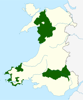
The national parks of Wales are managed areas of outstanding landscape in Wales, United Kingdom where some forms of development are restricted to preserve the landscape and natural environment. Together, they cover 20% of the land surface of Wales and have a resident population of over 80,000 people. Each National Park Authority is a free-standing body within the local government framework.

<span class="mw-page-title-main">Fan Brycheiniog</span> Hill (801.7m) in Powys, Wales

Fan Brycheiniog is the highest peak at a height of 802.5 metres (2,633 ft) in the Black Mountain region of the Brecon Beacons National Park in southern Wales. There is a trig point at the peak and on the edge of the escarpment, and nearby, a stone shelter with an inner seat. It lies just inside the historic county of Brecknockshire which gives the mountain its Welsh name. A subsidiary top, less than a kilometre from the summit along the ridge to the northwest, is the highest point of the neighboring county of Carmarthenshire. Fan Brycheiniog is also within the Fforest Fawr Geopark designated in 2005 in recognition of the area's geological heritage. The views of the moorland and open country to the north are spectacular when the weather is clear, and reveals the isolation of the range, especially when compared with the more popular Pen y Fan range to the east.

<span class="mw-page-title-main">Corn Du</span> Welsh mountain peak; part of Pen y Fan

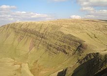
Corn Du is a summit of the twin topped Pen y Fan and the second highest peak in South Wales at 871.5 m (2,864 ft), situated in the Brecon Beacons National Park. The summit itself is marked by a well structured Bronze Age cairn with a central burial cist like that on nearby Pen y Fan. The two summits are visible from great distances owing to their height above the surrounding moorland, and are famous landmarks. The views from the peaks are also panoramic and very extensive, the Black Mountain and Fforest Fawr being especially obvious to the west. Mynydd Epynt is visible to the north behind the county town of Brecon, and other parts of the escarpment to the east.

<span class="mw-page-title-main">Beacons Way</span> Long distance path in mid wales

The Beacons Way is a waymarked long distance footpath in the Brecon Beacons National Park, Wales. It is a linear route which runs for 99 miles (159 km) east to west through the National Park, and passes many of the most important landmarks and mountain peaks in the mountain range. It also includes a few of the towns in the park as well as popular attractions such as Carreg Cennen Castle near Llandeilo at the western end of the path.

<span class="mw-page-title-main">Llyn y Fan Fach</span> Lake in south Wales

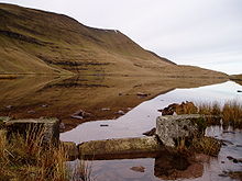
Llyn y Fan Fach is a lake of approximately 10 hectares on the northern margin of the Black Mountain in Carmarthenshire, South Wales and lying within the Brecon Beacons National Park. The lake lies at an altitude of approximately 1,660 feet (510 m), immediately to the north of the ridge of the Carmarthen Fans. It is the smaller of two lakes within this mountain massif: the slightly larger Llyn y Fan Fawr is about 2 miles (3.2 km) to the east.

<span class="mw-page-title-main">Fforest Fawr</span> Upland area in Powys, Wales

Fforest Fawr is an extensive upland area in the county of Powys, Wales. Formerly known as the Great Forest of Brecknock in English, it was a royal hunting area for several centuries but is now used primarily for sheep grazing, forestry, water catchment and recreation. It lies within the Brecon Beacons National Park.

The Nant Gwys is a river flowing off the Black Mountain in Powys, Wales. Its tributaries Gwys Fawr and the Gwys Fach flow south from Banwen Gwyn and Bwlch y Ddeuwynt respectively and join forces to form the Nant Gwys proper which then flows for about 5 km / 3 mi to its confluence with the Afon Twrch at Cwm-twrch-Uchaf.

<span class="mw-page-title-main">Llyn y Fan Fawr</span> Lake in Powys, Wales

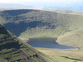
Llyn y Fan Fawr is a natural lake in the county of Powys, Wales. It lies at the foot of Fan Brycheiniog, the highest peak of the Black Mountain range within the Brecon Beacons National Park. Created as a result of glacial action, it is one of the largest glacial lakes in southern Wales. The lake is roughly rectangular in shape with its long axis oriented roughly north–south.

<span class="mw-page-title-main">Fan Hir</span> Mountain (760m) in Powys, Wales

Fan Hir is a peak at the eastern end of the Black Mountain in the Brecon Beacons National Park in southern Wales. It is a subsidiary summit of Fan Brycheiniog. It falls within the county of Powys and is also a part of the traditional area of Fforest Fawr. Its Welsh name means "long peak", a fitting description, particularly if seen from the east when its steep eastern face is seen to advantage. It is about 2.5 miles or 4 km long and faces east. Its summit is 2490 feet above sea level. Fan Hir is separated from its higher neighbour to the north-west, Fan Brycheiniog by a col known as Bwlch Giedd, where a path rises from Llyn y Fan Fawr via a stone staircase.

<span class="mw-page-title-main">Llyn Cwm Llwch</span> Small lake in Wales

Llyn Cwm Llwch is a small lake or pool in the Brecon Beacons National Park in Powys, Wales. It is between 1 and 2 acres: much smaller than the two glacial lakes in the west of the Black Mountain (range): Llyn y Fan Fawr and Llyn y Fan Fach, and one of the few natural bodies of water in the park. It is of glacial origin, occupying a rock hollow beneath the peaks of Pen y Fan and Corn Du in the central Brecon Beacons. It is drained by the Nant Cwm Llwch which empties into the Afon Tarell, which itself enters the River Usk at Brecon. Tommy Jones' obelisk, a memorial in granite to a young boy who died near this spot in 1900, overlooks the lake.

Fforest Fawr Geopark is a Geopark in the Brecon Beacons National Park, south Wales. It is the first designated Geopark in Wales having gained membership of both the European Geoparks Network and the UNESCO-assisted Global Network of National Geoparks in October 2005. The Geopark aims to promote and support sustainable tourism and other opportunities to improve the economy of the area whilst safeguarding the natural environment. Its aims largely coincide with the statutory duties and purpose of the National Park within which it sits.

<span class="mw-page-title-main">Fforest Fach</span> Unenclosed area of Powys, Wales

Fforest Fach is a small area of unenclosed land within Brecon Beacons National Park southwest of Sennybridge in the county of Powys, Wales. Translating from Welsh as 'little forest', it is named in opposition to the much larger area of unenclosed land to the south which is known as Fforest Fawr or the 'great forest'. Whilst Fforest Fawr and Fforest Fach have been distinct areas for many centuries, the odd situation now arises where Fforest Fach now finds itself within Fforest Fawr Geopark, the boundaries of which are drawn rather more widely than those of the traditional royal hunting forest.
The hill possesses two indistinct summits, the higher of which at 382m is in the south whilst that to the north at 381m is crowned by a trig point. There was formerly a rifle range at the north-western corner of the hill.

<span class="mw-page-title-main">Y Garn Goch</span> Hill in Carmarthenshire, Wales

Y Garn Goch is a hill in the Brecon Beacons National Park in the east of Carmarthenshire, Wales. The name means the 'red cairn'. It lies near the village of Bethlehem, three miles southwest of Llangadog and four miles east of Llandeilo on the southern side of the broad Towy Valley. It is also commonly known as either Garn Goch or Carn Goch. Current owners and land managers are the Brecon Beacons National Park Authority.

<span class="mw-page-title-main">River Sawdde</span> River in Carmarthenshire, Wales

The Afon Sawdde is a river in the county of Carmarthenshire, Wales. For most of its course it flows through the Brecon Beacons National Park and Fforest Fawr Geopark.

<span class="mw-page-title-main">Waun Lefrith</span> Hill (676.1m) in Carmarthenshire, Wales

Waun Lefrith is a top of Picws Du and is also the westernmost of the Carmarthen Fans, a group of peaks within the Black Mountain of the Brecon Beacons National Park. It lies within Carmarthenshire, Wales. The summit plateau of the mountain reaches a height of 2221 feet above sea level. Picws Du and Fan Foel are the other, higher summits of the Carmarthen Fans. The glacial lake of Llyn y Fan Fach dominates the panorama to the north of the peak. Beyond the lake to the north lies the Usk Reservoir and then the Cambrian Mountains on the horizon. Swansea Bay and the Bristol Channel are visible to the south across the undulating dip slope of the mountain. The Towy (Tywi) valley lies to the west, with Llandovery and Llandeilo as important market towns nearest to the hills.

<span class="mw-page-title-main">Picws Du</span> Mountain (749.1m) in Carmarthenshire, Wales

Picws Du is the second highest peak of the Carmarthen Fans in the Carmarthenshire section of the Black Mountain in the west of the Brecon Beacons National Park in south Wales. The highest peak is Fan Foel immediately next along the ridge and it is a subsidiary summit of Fan Brycheiniog. Picws Du falls within Fforest Fawr Geopark and its prominent summit is marked by a large Bronze Age round barrow at a height of 2457 feet above sea level. Waun Lefrith is the other, lower summit of the Bannau Sir Gâr / Carmarthen Fans situated to the west. The peak overlooks the glacial lake of Llyn y Fan Fach in the cwm below. As the peak sits on the edge of the escarpment on a ridge which juts out into the valley below, the views from the summit are panoramic and extensive. The views to the north are especially impressive when the weather is clear, looking towards the Cambrian Mountains, Mynydd Epynt and Brecon. Swansea and the Bristol Channel can just be seen on the horizon to the south, across the gently falling dip slope. Pen y Fan and Corn Du are distinctive landmarks seen directly to the east across Fforest Fawr.

This article describes the geology of the Brecon Beacons National Park in mid/south Wales. The area gained national park status in 1957 with the designated area of 1,344 km2 (519 sq mi) including mountain massifs to both the east and west of the Brecon Beacons proper. The geology of the national park consists of a thick succession of sedimentary rocks laid down from the late Ordovician through the Silurian and Devonian to the late Carboniferous period. The rock sequence most closely associated with the park is the Old Red Sandstone from which most of its mountains are formed. The older parts of the succession, in the northwest, were folded and faulted during the Caledonian orogeny. Further faulting and folding, particularly in the south of the park is associated with the Variscan orogeny.

The bedrock geology of Carmarthenshire in west Wales consists largely of Palaeozoic age sedimentary rocks. Unconsolidated deposits of Quaternary age in Carmarthenshire include a dissected cover of glacial till, valley floor alluvium and some scattered peat deposits in both upland and lowland settings. There are extensive beach and tidal flat deposits along the Carmarthenshire coast. The exploitation of the county's mineral riches, particularly coal and limestone, was a key part of the local economy through much of the nineteenth and twentieth centuries.

References

  1. "Geopark — Brecon Beacons National Park Authority". www.breconbeacons.org. Archived from the original on 4 December 2008. Retrieved 13 January 2022.
  2. Morgan, R. 2005. Place-names of Gwent Gwasg Carreg Gwalch, Llanrwst ISBN   0-86381-956-7
  3. Toulmin Smith, Lucy (ed.), The Itinerary in Wales of John Leland in or about the years 1536-1539, Vol. 3 Archived April 28, 2016, at the Wayback Machine Containing Part 6 (The Itinerary in Wales), with a Map, London, 1906
  4. Ordnance Survey 1:25,000 scale Explorer map sheet OL12 Brecon Beacons National Park: western area
  5. "Reservoirs". Fforest Fawr Geopark. Brecon Beacons National Park Authority. Retrieved 29 December 2021.
  6. Ordnance Survey Explorer map OL12 'Brecon Beacons National Park: western area'
  7. "Geopark Timeline — Fforest Fawr Geopark". Archived from the original on 16 July 2011. Retrieved 30 September 2010.

51°52′53″N3°42′31″W / 51.88144°N 3.70848°W / 51.88144; -3.70848