Borough of Gedling

Last updated

Borough of Gedling
Gedling
Arnold Town Centre 6527.jpg
Arnold, the largest settlement and the administrative centre of the district
Coat of Arms of Gedling.svg
Gedling UK locator map.svg
Shown within Nottinghamshire
Sovereign state United Kingdom
Constituent country England
Region East Midlands
Administrative county Nottinghamshire
Administrative headquarters Arnold
Government
  TypeGedling Borough Council
   MPs: Tom Randall,
Mark Spencer
Area
  Total50 sq mi (120 km2)
  Rank 179th
Population
 (2022)
  Total117,730
  Rank Ranked 205th
  Density2,500/sq mi (980/km2)
Ethnicity (2021)
[1]
   Ethnic groups
List
Religion (2021)
[1]
   Religion
List
Time zone UTC+0 (Greenwich Mean Time)
  Summer (DST) UTC+1 (British Summer Time)
ONS code 37UE (ONS)
E07000173 (GSS)

Gedling is a local government district with borough status in Nottinghamshire, England. The council is based in Arnold. The borough also includes Carlton along with villages and rural areas to the north-east of Nottingham. The main built-up part of the borough around Arnold and Carlton forms part of the Nottingham Urban Area.

Contents

The neighbouring districts are Ashfield, Newark and Sherwood, Rushcliffe and Nottingham.

History

The district was formed on 1 April 1974 under the Local Government Act 1972. The new district covered the whole area of two former districts and part of a third, which were all abolished at the same time: [2]

The new district was named after the old village of Gedling. [3] [4] The civil parish of Gedling had been abolished in 1935 and absorbed into the Carlton Urban District. [5]

The new Gedling district was granted borough status from its creation, allowing the chair of the council to take the title of mayor. [6]

Governance

Gedling Borough Council
Gedling Borough Council logo.svg
Type
Type
Leadership
Julie Najuk,
Labour
since 24 May 2023
John Clarke,
Labour
since 18 May 2011
Mike Hill
since July 2020 [7]
Structure
Seats41 councillors
Political groups
Administration (26)
  Labour (26)
Other parties (13)
  Conservative (9)
  Liberal Democrat (4)
  Independent (2)
Elections
First past the post
Last election
4 May 2023
Next election
6 May 2027
Meeting place
Gedling Civic Centre.jpg
Civic Centre, Arnot Hill Park, Arnold, Nottingham, NG5 6LU
Website
www.gedling.gov.uk
Carlton, the second largest settlement in the borough Carlton across the Trent - geograph.org.uk - 2237060.jpg
Carlton, the second largest settlement in the borough

Gedling Borough Council provides district-level services. County-level services are provided by Nottinghamshire County Council. Parts of the borough are also covered by civil parishes, which form a third tier of local government. [8]

Political control

The council has been under Labour majority control since 2011.

The first election to the council was held in 1973, initially operating as a shadow authority alongside the outgoing authorities until the new arrangements took effect on 1 April 1974. Political control of the council since 1974 has been as follows: [9] [10]

Party in controlYears
Conservative 1974–1995
Labour 1995–1999
Conservative 1999–2003
No overall control 2003–2007
Conservative 2007–2011
Labour 2011–present

Leadership

The role of mayor is largely ceremonial in Gedling. Political leadership is instead provided by the leader of the council. The leaders since 2003 have been: [11] [12]

CouncillorPartyFromTo
Ivan Gollop Labour 20032004
Roland Spencer Conservative 200411 May 2005
Ivan Gollop Labour 11 May 200510 May 2006
Roland Spencer Conservative 10 May 200618 May 2011
John Clarke Labour 18 May 2011

Composition

Following the 2023 election and changes of allegiance reported in November 2023, the composition of the council was: [13] [14]

PartyCouncillors
Labour 26
Conservative 9
Liberal Democrats 4
Independent 2
Total39

The next election is due in 2027.

Premises

The council is based at the Civic Centre in Arnot Hill Park. The building was purpose-built for the council in 1985 at a cost of £2.2 million. It was formally opened by Princess Anne on 1 November 1985. [15]

Elections

Since the last boundary changes in 2015 the council has comprised 41 councillors representing 19 wards, with each ward electing one, two or three councillors. Elections are held every four years. [16]

Wards

The wards are: [16] [17]

  • Bestwood St Albans
  • Calverton
  • Carlton
  • Carlton Hill
  • Cavendish
  • Colwick
  • Coppice
  • Daybrook
  • Dumbles
  • Ernehale
  • Gedling
  • Netherfield
  • Newstead Abbey
  • Phoenix
  • Plains
  • Porchester
  • Redhill
  • Trent Valley
  • Woodthorpe

Parliamentary

The borough is covered by two parliamentary constituencies. The more urban southern part of the borough adjoining Nottingham is in the Gedling constituency, which until 1983 was known as Carlton. The more rural northern part of the borough, including Calverton and Ravenshead, forms part of the Sherwood constituency. [18]

Parishes

There are twelve civil parishes in the borough. The former Arnold Urban District and most of the former Carlton Urban District comprise an unparished area. The parish of Stoke Bardolph has a parish meeting rather than a parish council due to its small population. [19] [18]

Culture

The Bonington Theatre in Arnold is named after the landscape painter Richard Parkes Bonington. [20]

The borough contains Newstead Abbey, a former Augustinian Priory. The building was converted into a house following the dissolution of the monasteries and was later the seat of the Byron family, including Lord Byron.

Arms

Coat of arms of Borough of Gedling
Coat of Arms of Gedling.svg
Crest
On a wreath of the colours issuant from a mural crown Or in front of two arrows in saltire points downwards a torch Sable enflamed Proper.
Escutcheon
Azure an oak tree fructed and eradicated Or on a chief lozengy Argent and Sable tree garbs of the second.
Supporters
On the dexter side a stag and on the sinister side a bear both Proper.
Motto
Omnibus Optimum (The Best For All) [21]

Freedom of the Borough

The following people and military units have received the Freedom of the Borough of Gedling.

Individuals

Military units

Related Research Articles

<span class="mw-page-title-main">Vernon Coaker</span> British Labour politician

Vernon Rodney Coaker, Baron Coaker is a British politician and life peer serving as Shadow Spokesperson for Home Affairs and Defence since 2021. A member of the Labour Party, he was Member of Parliament (MP) for Gedling from 1997 to 2019.

<span class="mw-page-title-main">Carlton, Nottinghamshire</span> Town in Nottinghamshire, England

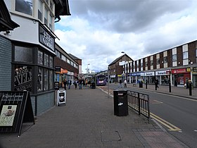
Carlton is a town in the Borough of Gedling, Nottinghamshire, England. It is to the east of Nottingham. The population at the 2011 Census was 6,881. It was an urban district until 1974, whose wards had an estimated population of 48,416 in 2015. Owing to the growth of residential, commercial and industrial in the wider Gedling Borough, City of Nottingham, Borough of Broxtowe, Rushcliffe and Ashfield District, as well as the Amber Valley and Borough of Erewash in Derbyshire which have become quite urban around Nottingham, Carlton and Gedling, as well as Netherfield form a contiguous urban area.

<span class="mw-page-title-main">Rushcliffe (UK Parliament constituency)</span> Nottinghamshire constituency from 1885

Rushcliffe is a constituency in Nottinghamshire represented in the House of Commons of the UK Parliament from 2019 by Ruth Edwards, a Conservative.

<span class="mw-page-title-main">Sherwood (UK Parliament constituency)</span> Parliamentary constituency in the United Kingdom, 1983 onwards

Sherwood is a constituency represented in the House of Commons of the UK Parliament since 2010 by Mark Spencer, a Conservative. The constituency's name is common with Sherwood Forest which is in the area.

<span class="mw-page-title-main">Broxtowe (UK Parliament constituency)</span> Parliamentary constituency in the United Kingdom, 1983 onwards

Broxtowe is a parliamentary constituency in Nottinghamshire, England, represented in the House of Commons of the UK Parliament since 2019 by Darren Henry, a Conservative.

<span class="mw-page-title-main">Gedling (UK Parliament constituency)</span> Parliamentary constituency in the United Kingdom, 1983 onwards

Gedling is a constituency in Nottinghamshire created in 1983 represented in the House of Commons of the UK Parliament since 2019 by Tom Randall of the Conservative Party. The seat was a safely Conservative until the Labour Party's landslide victory in 1997, when it was won for Labour by Vernon Coaker. Labour held Gedling until 2019, when it was regained by the Conservative Party.

<span class="mw-page-title-main">Ravenshead</span> Village and civil parish in Nottinghamshire, England

Ravenshead is a large village and civil parish in the Gedling district of Nottinghamshire, England. It borders Papplewick, Newstead Abbey and Blidworth, and is part of Nottinghamshire's Hidden Valleys area. According to the 2001 census it had a population of 5,636, reducing marginally to 5,629 at the 2011 census, but increasing to 5,891 at the 2021 census.

<span class="mw-page-title-main">Colwick</span> Village and civil parish in Nottinghamshire, England

Colwick is a village and civil parish, in the Borough of Gedling of Nottinghamshire, England. It is situated to the east of Nottingham's city boundary, and forms the Colwick ward. At the time of the 2011 census, the village had a population of 2,829, falling to 2,778 at the 2021 census.

<span class="mw-page-title-main">Broxtowe Wapentake</span>

Broxtowe was a wapentake of the ancient county of Nottinghamshire, England.

<span class="mw-page-title-main">Basford Rural District</span> Rural district close to Nottingham, England

Basford was a rural district close to Nottingham, England, from 1894 to 1974. The district consisted of two detached parts, to the north and south of Nottingham. It was created under the Local Government Act 1894 based on the existing Basford rural sanitary district.

<span class="mw-page-title-main">Thurgarton Wapentake</span>

Thurgarton was a wapentake of the historic county of Nottinghamshire, England. It extended north-eastwards from Nottingham. The River Trent formed most of the eastern boundary. It consisted of the parishes of Averham, Bathley, Bleasby, Blidworth, Bulcote, Burton Joyce, Calverton, Carlton, Carlton-on-Trent, Caunton, Caythorpe, Colwick, Cromwell, East Stoke, Edingley, Epperstone, Farnsfield, Fiskerton, Fiskerton cum Morton, Fledborough, Gedling, Gonalston, Grassthorpe, Gunthorpe, Halam, Halloughton, Haywood Oaks, Hockerton, Holme, Hoveringham, Kelham, Kersall, Kirklington, Kneesall, Lambley, Lindhurst, Lowdham, Maplebeck, Marnham, Meering, Morton, Normanton on Trent, North Muskham, Norwell, Norwell Woodhouse, Nottingham St Mary, Ossington, Oxton, Park Leys, Rolleston, Sneinton, South Muskham, Southwell, Staythorpe, Stoke Bardolph, Sutton on Trent, Thurgarton, Upton, Weston, Winkburn and Woodborough.

<span class="mw-page-title-main">Gedling</span> Village in Nottinghamshire, England

Gedling is a village and former civil parish which gives its name to the larger Borough of Gedling in Nottinghamshire, England. It lies 4 miles (6.4 km) north-east of Nottingham city centre. The parish was abolished in 1935 and absorbed into the urban district of Carlton, which in turn was abolished in 1974 on the creation of borough of Gedling. The population of the Gedling ward at the 2011 census was 6,817 and 111,787 for the district. Gedling was recorded in the Domesday Book and is still a distinct settlement, although residential, commercial and industrial growth in the wider borough of Gedling and the neighbouring city of Nottingham, boroughs of Broxtowe and Rushcliffe and district of Ashfield means it can be difficult to distinguish the village of Gedling from the nearby town of Carlton, with which it has become contiguous.

<span class="mw-page-title-main">Netherfield, Nottinghamshire</span> Town in Nottinghamshire, England

Netherfield is a town in the Borough of Gedling in Nottinghamshire, England. It is situated to the east of Nottingham's city boundary and is approximately 3 miles (4.8 km) between Colwick and Carlton in the NG4 postcode area, and near the River Trent. The appropriate Gedling ward was called 'Netherfield and Colwick' until boundary reorganisation in 2015, when it became 'Netherfield', with 'Colwick' becoming a separate ward.. At the time of the 2011 census, the population of this ward was 7,398.

Carlton was a constituency in Nottinghamshire which returned one Member of Parliament (MP) to the House of Commons of the Parliament of the United Kingdom from 1950 until it was abolished for the 1983 general election. It was then partly replaced by the new Gedling constituency.

<span class="mw-page-title-main">Killisick</span> Area of the town of Arnold, Nottinghamshire, England

Killisick is an area of the market town of Arnold in the ceremonial county of Nottinghamshire in the East Midlands of England. It also used to be a local government ward area of Gedling borough until 2015. The population of the ward as it stood at the 2011 census was 2,595. The area is currently contained within the newly created Coppice ward.

There are a number of listed buildings in Nottinghamshire. The term "listed building", in the United Kingdom, refers to a building or structure designated as being of special architectural, historical, or cultural significance. Details of all the listed buildings are contained in the National Heritage List for England. They are categorised in three grades: Grade I consists of buildings of outstanding architectural or historical interest, Grade II* includes significant buildings of more than local interest and Grade II consists of buildings of special architectural or historical interest. Buildings in England are listed by the Secretary of State for Culture, Media and Sport on recommendations provided by English Heritage, which also determines the grading.

References

  1. 1 2 UK Census (2021). "2021 Census Area Profile – Gedling Local Authority (E07000173)". Nomis. Office for National Statistics . Retrieved 5 January 2024.
  2. "The English Non-metropolitan Districts (Definition) Order 1972", legislation.gov.uk , The National Archives, SI 1972/2039, retrieved 31 May 2023
  3. "Gedling". Britannica. Retrieved 8 August 2018.
  4. "The English Non-metropolitan Districts (Names) Order 1973", legislation.gov.uk , The National Archives, SI 1973/551, retrieved 31 May 2023
  5. "Gedling Ancient Parish / Civil Parish". A Vision of Britain through Time. GB Historical GIS / University of Portsmouth. Retrieved 2 July 2023.
  6. "District Councils and Boroughs". Parliamentary Debates (Hansard) . 28 March 1974. Retrieved 4 December 2021.
  7. "Council appoints new Chief Executive". Gedling Borough Council. 24 June 2020.
  8. "Local Government Act 1972", legislation.gov.uk , The National Archives, 1972 c. 70, retrieved 31 May 2023
  9. "Compositions calculator". The Elections Centre. Retrieved 10 August 2022.
  10. "England council elections". BBC News Online . Retrieved 21 August 2011.
  11. "Council minutes". Gedling Borough Council. Retrieved 20 August 2022.
  12. "Council leader history". What do they know?. 2 September 2020. Retrieved 20 August 2022.
  13. "Local elections 2023: live council results for England". The Guardian.
  14. Whittaker, Anna (2 November 2023). "Second Gedling councillor resigns from Labour Party over refusal to call for Israel-Gaza ceasefire". Gedling Eye. Retrieved 21 December 2023.
  15. "All Smiles!". Nottingham Evening Post. 1 November 1985. p. 1. Retrieved 2 July 2023.
  16. 1 2 "The Gedling (Electoral Changes) Order 2014", legislation.gov.uk , The National Archives, SI 2014/19, retrieved 2 July 2023
  17. Council, Gedling Borough. "Data about our Wards - Gedling Borough Council". www.gedling.gov.uk. Retrieved 6 September 2021.
  18. 1 2 "Election Maps". Ordnance Survey. Retrieved 2 July 2023.
  19. "Parish council contact details". Gedling Borough Council. Retrieved 2 July 2023.
  20. "Arnold". Gedling Borough Council website. Gedling Borough Council. Archived from the original on 8 April 2014. Retrieved 8 April 2014.
  21. "East Midlands Region". Civic Heraldry of England. Retrieved 5 March 2021.
  22. "Former MP Vernon Coaker granted freedom of Gedling borough in ceremony". The Gedling Eye. 17 June 2022. Retrieved 19 June 2022.
  23. "Mercian regiment awarded Freedom of Gedling". BBC News. 20 October 2010. Retrieved 19 June 2022.

52°58′31″N1°04′33″W / 52.97531°N 1.07597°W / 52.97531; -1.07597