Kimberley, Nottinghamshire

Last updated

Kimberley
Town and civil parish
Kimberley War Memorial, Nottinghamshire.JPG
Kimberley War Memorial
Kimberley, Nottinghamshire
Parish map
Nottinghamshire UK location map.svg
Red pog.svg
Kimberley
Location within Nottinghamshire
Area1.11 sq mi (2.9 km2)
Population6,033 (2021)
  Density 5,435/sq mi (2,098/km2)
OS grid reference SK 49995 44702
  London 110 mi (180 km)  SSE
District
Shire county
Region
Country England
Sovereign state United Kingdom
Areas of the town
List
Post town NOTTINGHAM
Postcode district NG16
Dialling code 0115
Police Nottinghamshire
Fire Nottinghamshire
Ambulance East Midlands
UK Parliament
Website www.kimberley-tc.gov.uk
List of places
UK
England
Nottinghamshire
52°59′49″N1°15′18″W / 52.997°N 1.255°W / 52.997; -1.255

Kimberley is a market town and civil parish in the Borough of Broxtowe in Nottinghamshire, England, lying 6 miles northwest of Nottingham along the A610. The town grew as a centre for coal mining, brewing and hosiery manufacturing. At the 2011 census the town had a population of 6,053, [1] and this fell to 6,033 at the 2021 census. [2]

Contents

History

Kimberley is referred to as Chinemarelie in William the Conqueror's Domesday Book. With the accession of William to the throne Kimberley came into the possession of William de Peveril. [3] The Peverils lost control when they supported the losing side in the civil war which preceded the accession of Henry II of England in 1154. The King became the owner of the land. King John of England granted land in the area to Ralph de Greasley in 1212 who took up residence at Greasley Castle and also at around this time to Henry de Grey whose son re-built Codnor Castle on the site of an earlier castle established by William Peveril. [4]

Ralph de Greasley's land passed by inheritance and marriage to Nicholas de Cantelupe who took part in Edward III of England's Scottish campaigns and also the Battle of Crécy. Nicholas founded Beauvale Priory using part of his Kimberley holding in 1343. That part of Kimberley which had become the property of Beauvale Priory was claimed by King Henry VIII during the Dissolution of the Monasteries in the 16th century. [4]

The Priory's land was redistributed by the King and came into the possession of Arthur Capell, 1st Baron Capell of Hadham again by inheritance and marriage in 1627. Arthur was beheaded in 1649 having fought for the Royalists in the English Civil War. Arthur's son was created Earl of Essex in 1661. [4]

In 1753 the land was purchased by Sir Matthew Lamb whose grandson William Lamb became Prime Minister in 1834. The Lamb's Kimberley estates passed by marriage to the 5th Earl Cowper in 1805 and on the death of the 7th Earl in 1913 were sold off in pieces. [4]

That part of Kimberley retained by the Cantelupe's passed by inheritance and marriage to John Lord Zouch who died at the Battle of Bosworth with Richard III in 1485. He was posthumously found guilty of high treason with his property forfeited to Henry VII. John Savage (-1491) received this part of Kimberley in gratitude for his efforts on behalf of Henry VII at Bosworth. The Savage family sold this land to the Earl of Rutland in the early 17th century. The Duke of Rutland's Kimberley estates were sold in parcels in the early 19th century. [4]

Industry

Kimberley has been home to a lot of industry including: coal mining, brewing and hosiery manufacturing.

All major industry in Kimberley has stopped, the last being Kimberley Brewery which ceased brewing in December 2006. Most businesses are now retail-based concerns.

Kimberley today

One of Kimberley's most notable structures is its unusual war memorial, in the form of a rotunda which is used as the emblem of Kimberley School. This secondary school has a catchment area which extends into the neighbouring areas of Nuthall, Eastwood, Watnall, and Hempshill Vale.

Kimberley Chapel of Rest on Knowle Hill Kimberley Chapel of Rest Small.jpg
Kimberley Chapel of Rest on Knowle Hill

On the south side of Kimberley lies Swingate, which has many different walking and cycling routes into the woods and surrounding countryside.

The twin towns of Kimberley are Échirolles in France and Grugliasco in Italy. [5]

Kimberley Brewery was taken over by Greene King in 2006, another major brewer in a multimillion-pound deal which marked the end of the traditional Kimberley Ales as ale brewing ceased shortly afterwards and only a distribution centre remained there.

The former Kimberley Brewery site has within its boundaries a geological Site of Special Scientific Interest (SSSI). It is listed under the title of "Kimberley Railway Cutting" [6] as an important location for Permian Gymnosperm fossils. The Permian - Carboniferous unconformity can be found in the Kimberley Railway Cutting.

Since 1974, Kimberley forms part of the borough of Broxtowe. From 1894 to 1974 it was part of Basford Rural District Council area.

There has been speculation that the Nottingham Express Transit (NET) want to extend their tram line that currently terminates at Phoenix Park stop through Kimberley towards Giltbrook Retail Park. [7]

Famous residents

Sport

Kimberley's distinctive water tower at Swingate Kimberley Water Tower, Nottinghamshire.JPG
Kimberley's distinctive water tower at Swingate

Media

Local news and television programmes are BBC East Midlands and ITV Central. Television signals are received from the Waltham TV transmitter, [10] and the Nottingham relay transmitter. [11]

Local radio stations are BBC Radio Nottingham, Capital East Midlands, Smooth East Midlands, Gem and Greatest Hits Radio Midlands. [12]

The town is served by local newspaper, Mansfield and Ashfield Chad (formerly Eastwood & Kimberley Advertiser). [13]

See also

Related Research Articles

<span class="mw-page-title-main">Nottinghamshire</span> County of England

Nottinghamshire is a ceremonial county in the East Midlands of England. The county borders South Yorkshire to the north-west, Lincolnshire to the east, Leicestershire to the south, and Derbyshire to the west. The largest settlement is the city of Nottingham (323,632).

<span class="mw-page-title-main">Worksop</span> Market town in Bassetlaw, Nottinghamshire, England

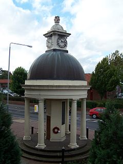
Worksop is a market town in the Bassetlaw District in Nottinghamshire, England. It is located 15 miles (24 km) south of Doncaster, 15 miles (24 km) south-east of Sheffield and 24 miles (39 km) north of Nottingham. Located close to Nottinghamshire's borders with South Yorkshire and Derbyshire, it is on the River Ryton and not far from the northern edge of Sherwood Forest. Other nearby towns include Chesterfield, Gainsborough, Mansfield and Retford. The population of the town was recorded at 44,733 in the 2021 Census.

<span class="mw-page-title-main">Eastwood, Nottinghamshire</span> Town and civil parish in Nottinghamshire, England

Eastwood is a former coal mining town and civil parish in the Broxtowe district of Nottinghamshire, England, 8 miles (13 km) northwest of Nottingham and 10 miles (16 km) northeast of Derby on the border between Nottinghamshire and Derbyshire. Mentioned in Domesday Book, it expanded rapidly during the Industrial Revolution. The Midland Railway was formed here and it is the birthplace of D. H. Lawrence.

<span class="mw-page-title-main">Borough of Broxtowe</span> Non-metropolitan district and borough in England

Broxtowe is a local government district with borough status in Nottinghamshire, England. It lies immediately west of the city of Nottingham, and most of the built-up areas of the borough form part of the Nottingham Urban Area. The council is based in Beeston and the borough also includes the towns of Eastwood, Kimberley and Stapleford and surrounding villages and rural areas.

<span class="mw-page-title-main">Broxtowe (UK Parliament constituency)</span> Parliamentary constituency in the United Kingdom, 1983 onwards

Broxtowe is a parliamentary constituency in Nottinghamshire, England, represented in the House of Commons of the UK Parliament since 2019 by Darren Henry, a Conservative.

<span class="mw-page-title-main">Stapleford, Nottinghamshire</span> Human settlement in England

Stapleford is a town and civil parish in the Borough of Broxtowe, Nottinghamshire, England, 6 miles (9.7 km) west of Nottingham. The population at the 2011 census was 15,241.

Broxtowe Borough Council elections are held every four years. Broxtowe Borough Council is the local authority for the non-metropolitan district of Borough of Broxtowe in Nottinghamshire, England. Since the full review of boundaries in 2015, 44 councillors are elected from 20 wards.

<span class="mw-page-title-main">Strelley Village</span> Human settlement in England

Strelley is a village and civil parish in the Borough of Broxtowe and City of Nottingham in Nottinghamshire, England. It is to the west of Nottingham. The population of the civil parish taken at the 2011 census was 653. It is also the name of the nearby post war council housing estate. The village lies within the Broxtowe district, whilst the estate is in the City of Nottingham. The village is separated from the housing estate by the A6002 road.

<span class="mw-page-title-main">Beauvale Priory</span> Carthusian monastery in Beauvale, Nottinghamshire

Beauvale Priory was a Carthusian monastery in Beauvale, Nottinghamshire. It is a scheduled ancient monument.

<span class="mw-page-title-main">Greasley</span> Civil parish in England

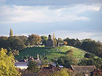
Greasley is a civil parish north west of Nottingham in Nottinghamshire, England. Although it is thought there was once a village called Greasley, there is no settlement of that name today as it was destroyed by the Earl of Rutland. The built up areas in the parish are Beauvale, Giltbrook, Moorgreen, Newthorpe, Watnall and parts of Eastwood, Kimberley and Nuthall. There is also a small hamlet known as Bog-End. The parish is one of the largest in Nottinghamshire at 7.63 square miles (19.8 km2), the 2001 UK Census reporting it had a total population of 10,467, increasing to 11,014 in 2011, and 11,241 at the 2021 census.

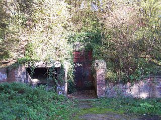
Watnall is an area in the Borough of Broxtowe in Nottinghamshire, England. It is part of Greasley civil parish, and is located one mile north of Kimberley. It is in the Nuthall West and Greasley (Watnall) ward of Broxtowe Council. The village is barely separated from Nuthall. Watnall Hall was built c. 1690 and demolished in 1962. Today, only the gate piers, fragments of the stone boundary wall and lodge remain on Main Road. Its owners included Launcelot Rolleston in the 18th century. Even though only a village, Watnall is home to many businesses and organisations, such as British Bakeries and the Nottingham meteorological centre. There are three World War II bunkers in Watnall that served as Royal Air Force Fighter Command for the Midlands.#

<span class="mw-page-title-main">Kimberley East railway station</span> Former railway station in Nottinghamshire, England

Kimberley East Railway Station was a station serving the town of Kimberley in Nottinghamshire, England.

<span class="mw-page-title-main">Kimberley West railway station</span> Former railway station in Nottinghamshire, England

Kimberley West railway station was a station serving the town of Kimberley in Nottinghamshire, England.

<span class="mw-page-title-main">Watnall railway station</span> Former railway station in Nottinghamshire, England

Watnall railway station was a station serving the village of Watnall in Nottinghamshire, England. The station opened in 1882 and closed in 1917. It was sited at the eastern end of the railway cutting used to provide the Midland Railway with a route through to Kimberley.

<span class="mw-page-title-main">Moorgreen</span> Settlement in England

Moorgreen is a hamlet in the Broxtowe district of Nottinghamshire, England. It is 115 miles (185 km) north west of London, 7 miles (11 km) north west of the city of Nottingham, and 1+14 miles (2 km) north east of the nearest town Eastwood. It is a linear settlement within the civil parish of Greasley.

Parish council elections took place across Broxtowe's parishes on 2 May 2019, alongside local elections in the borough.

<span class="mw-page-title-main">2023 Broxtowe Borough Council election</span> 2023 English local election

The 2023 Broxtowe Borough Council election took place on 4 May 2023, to elect all 44 members of Broxtowe Borough Council in England. This took place as part of the 2023 United Kingdom local elections.

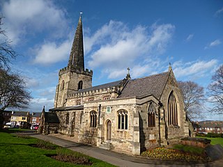
Greasley is a civil parish in the Borough of Broxtowe, Nottinghamshire, England. The parish contains 30 listed buildings that are recorded in the National Heritage List for England. Of these, two are listed at Grade II*, the middle of the three grades, and the others are at Grade II, the lowest grade. The parish contains the settlements of Beauvale, Moorgreen and Watnall and the surrounding area. Most of the listed buildings are houses, cottages and associated structures, farmhouses and farm buildings. The others include the remains of a fortified manor house, a church and a former chapel, and a school.

References

  1. "Broxtowe ward population 2011". Neighbourhood Statistics. Office for National Statistics. Retrieved 11 April 2016.
  2. UK Census (2021). "2021 Census Area Profile – Kimberley (Broxtowe) parish (E04007860)". Nomis. Office for National Statistics . Retrieved 25 January 2024.
  3. Domesday Book: A Complete Transliteration. London: Penguin, 2003. ISBN   0-14-143994-7 p.772
  4. 1 2 3 4 5 Lee, J.M. A Brief History of Kimberley.
  5. "Twin Towns". Archived from the original on 24 June 2007.
  6. "Kimberley Railway Cutting".
  7. "Tram Extension: Supporters of Line to Kimberley Walk Route | East Midlands News". Archived from the original on 4 March 2016. Retrieved 12 January 2015.
  8. "John Reynolds".
  9. "Richard Bolitho". Archived from the original on 10 April 2009. Retrieved 13 July 2009.
  10. "Full Freeview on the Waltham (Leicestershire, England) transmitter". UK Free TV. 1 May 2004. Retrieved 12 December 2023.
  11. "Nottingham (Nottinghamshire, England) Full Freeview transmitter". UK Free TV. 1 May 2004. Retrieved 12 December 2023.
  12. "Local news and radio". Nottinghamshire County Council. Retrieved 12 December 2023.
  13. "Eastwood & Kimberley Advertiser". British Papers. 11 December 2013. Retrieved 12 December 2023.

Further reading