
The Vale of Glamorgan, often referred to as The Vale, is a county borough in Wales, bordering Bridgend, Cardiff, and Rhondda Cynon Taf. With an economy based largely on agriculture and chemicals, it is the southernmost unitary authority in Wales. Attractions include Barry Island Pleasure Park, the Barry Tourist Railway, Medieval wall paintings in St Cadoc's Church, Llancarfan, Porthkerry Park, St Donat's Castle, Cosmeston Lakes Country Park and Cosmeston Medieval Village.

Llanelli is a market town and the largest community in Carmarthenshire and the preserved county of Dyfed, Wales. It is located on the Loughor estuary 10.5 miles (16.9 km) north-west of Swansea and 12 miles (19 km) south-east of the county town, Carmarthen. The town had a population of 25,168 in 2011, estimated in 2019 at 26,225. The local authority was Llanelli Borough Council when the county of Dyfed existed, but it has been under Carmarthenshire County Council since 1996.

South Wales is a loosely defined region of Wales bordered by England to the east and mid Wales to the north. It has a population of around 2.2 million, almost three-quarters of the whole of Wales, including 400,000 in Cardiff, 250,000 in Swansea and 150,000 in Newport. Generally considered to include the historic counties of Glamorgan and Monmouthshire, South Wales extends westwards to include Carmarthenshire and Pembrokeshire. In the western extent, from Swansea westwards, local people would probably recognise that they lived in both south Wales and west Wales. The Brecon Beacons National Park covers about a third of South Wales, containing Pen y Fan, the highest British mountain south of Cadair Idris in Snowdonia.

Whitchurch is a suburb and community in the north of Cardiff, capital of Wales. It is approximately 3 miles north of the centre of the city on the A470 road and A4054 road. It falls within the Whitchurch & Tongwynlais ward. The population of the community in 2011 was 14,267.

Pentyrch is a village and community located on the western outskirts of Cardiff, the capital city of Wales. The village gives its name to a Cardiff local authority electoral ward, Pentyrch, which covers the village and immediate surrounding area. The Pentyrch community includes the neighbouring village of Creigiau and Gwaelod y Garth. People living in Pentyrch are commonly known as "Penterchyians".

The Vale of Glamorgan Line is a commuter railway line in Wales, running through the Vale of Glamorgan from Barry to Bridgend, via Rhoose and Llantwit Major.

Pontyclun railway station is an unstaffed, minor railway station in Pontyclun, in the County Borough of Rhondda Cynon Taf, South Wales. The station is at street level, on Station Approach, Pontyclun. It is a stop on the South Wales Main Line, served by trains on the Maesteg Line, and occasionally by the Swanline Cardiff to Swansea regional services, as well as one early-morning daily service to Manchester and a late-night daily service to Carmarthen. The station and all trains are operated by Transport for Wales Rail.

Blandford St Mary is a village and civil parish in the North Dorset district of Dorset, England. The village is on the south bank of the River Stour, immediately opposite the larger town of Blandford Forum. The village grew up around the Badger Brewery, owned by Hall and Woodhouse, which is based there. At the 2001 census it had a population of 1,233. The appropriate electoral ward is called 'Portman' with naturally the most populous area being south of the river. The ward includes Bryanston School and also runs south west almost to Thornicombe. The total ward population at the abovementioned census was 2,436.
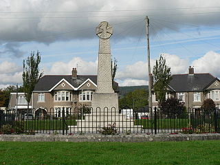
Pontyclun is a village and community located in the County Borough of Rhondda Cynon Taf, Wales. Like the surrounding towns, it has seen a sharp increase in its population in the last ten years as people migrate south from the Valleys in the south of Wales and west from the capital city of Cardiff.
Pontprennau is a ward and community in the north of the city of Cardiff, Wales, lying north of Pentwyn and Cyncoed, between the village of Old St Mellons and the farmlands east of Lisvane. The community had a population of 7,353 in 2011.

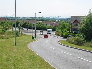
Talbot Green is a town just north of the M4 motorway, in the County Borough of Rhondda Cynon Taf, Wales in the United Kingdom. The town is part of Llantrisant Community Council.

The A4119 links Tonypandy with Cardiff in South Wales.

The River Ely is in South Wales flowing generally southeast, from Tonyrefail to Cardiff.

Llanharan Rugby Football Club is a rugby union club based in Llanharan, South Wales. Llanharan RFC was formally established in 1891-92 when Llanharan was little more than an agricultural hamlet. The earliest photograph on the clubhouse wall is dated 1898. Llanharan RFC is a member of the Welsh Rugby Union and is a feeder club for the Cardiff Blues.
Church Village is a large village in the historic parish and community of Llantwit Fardre, located within the Taff Ely district of the County Borough of Rhondda Cynon Taf in Wales. The village is centrally located being around 4 miles from the local principal towns of Llantrisant to the southwest and Pontypridd to the north and is situated around 10 miles northwest of Cardiff city centre.

The Afon Clun is a 14-mile (23 km) long tributary of the River Ely, in the counties of Cardiff and Rhondda Cynon Taf, Wales. Its bedrock is predominantly of sandstone. Beginning on the western slope of The Garth the river is fast-flowing, in clear shallow water with a hard substrate, flowing to the south of Llantrisant and generally west to its confluence with the River Ely at Pontyclun, falling 715 feet (218 m) over its course.
Pontyclun Football Club is an amateur Welsh football club, founded in 1896 which plays its matches at Ivor Park, Pontyclun. It plays in the Ardal Leagues South West, the third tier of the Welsh football pyramid.
The 2009–10 FAW Welsh Cup was the 123rd edition of the annual knockout tournament for competitive football teams in Wales, excluding those who play in the English League System. The 2009–10 tournament commenced on 14 August 2009 and concluded at Parc y Scarlets on 1 May 2010. Bangor City won the cup with a 3–2 win against Port Talbot Town.
Simon David Hill is a Welsh International rugby union player. He made twelve appearances for his country, as well as representing Cardiff RFC and Bridgend RFC in the top division of Welsh club rugby.

Rhiwsaeson is a village and district of the principal town and community of Llantrisant with the County Borough of Rhondda Cynon Taf in South Wales. It is located on the south easterly outskirts of the town, along the Afon Clun, south of the A473 and near the village of Groes-faen (Pontyclun) and Creigiau within North West Cardiff.


