
Aberdare is a town in the Cynon Valley area of Rhondda Cynon Taf, Wales, at the confluence of the Rivers Dare (Dâr) and Cynon. Aberdare has a population of 39,550. Aberdare is 4 miles (6 km) south-west of Merthyr Tydfil, 20 miles (32 km) north-west of Cardiff and 22 miles (35 km) east-north-east of Swansea. During the 19th century it became a thriving industrial settlement, which was also notable for the vitality of its cultural life and as an important publishing centre.

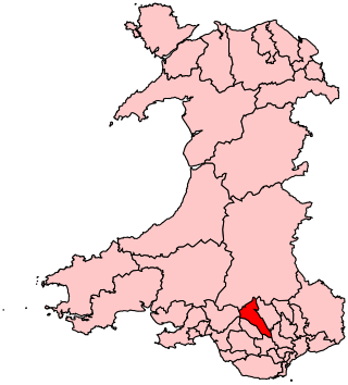
Rhondda Cynon Taf is a county borough in the south-east of Wales. It consists of five valleys: the Rhondda Fawr, Rhondda Fach, Cynon, Taff and Ely valleys, plus a number of towns and villages away from the valleys. Results from the 2011 census showed 19.1% of its 234,410 residents self-identified as having some ability in the use of the Welsh language. The county borough borders Merthyr Tydfil County Borough and Caerphilly County Borough to the east, Cardiff and the Vale of Glamorgan to the south, Bridgend County Borough and Neath Port Talbot to the west and Powys to the north. Its principal towns are - Aberdare, Llantrisant with Talbot Green and Pontypridd, with other key settlements/towns being - Maerdy, Ferndale, Hirwaun, Llanharan, Mountain Ash, Porth, Tonypandy, Tonyrefail and Treorchy.

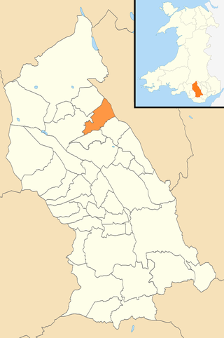
Cynon Valley is a former coal mining valley in Wales. It lies between Rhondda and the Merthyr Valley and takes its name from the River Cynon. Aberdare is located in the north of the valley and Mountain Ash in the south. From 1974 to 1996, Cynon Valley was a local government district.

Treorchy is a town and community in Wales. Once a mining town, it retains such characteristics. Situated in the county borough of Rhondda Cynon Taf in the Rhondda Fawr valley. Treorchy is also one of the 16 communities of the Rhondda. It includes the villages of Cwmparc and Ynyswen.

Ynysybwl is a village in Cwm Clydach in Wales. It is situated in the county borough of Rhondda Cynon Taf, roughly 15 miles (24 km) north-north-west of Cardiff, 4 miles (6 km) north of Pontypridd and 16 miles (26 km) south of Merthyr Tydfil, and forms part of the community of Ynysybwl and Coed-y-Cwm.

Abercynon, is both a village and a community in the Cynon Valley within the unitary authority of Rhondda Cynon Taf, Wales. The community comprises the village and the districts of Carnetown and Grovers Field to the south, Navigation Park to the east, and Glancynon to the north.
Cynon Valley is a constituency in Wales represented in the House of Commons of the UK Parliament since 2019 by Beth Winter of the Labour Party.

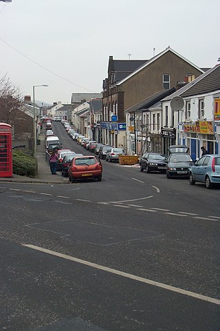
Hirwaun is a village and community at the north end of the Cynon Valley in the County Borough of Rhondda Cynon Taf, South Wales. It is 4 miles (6 km) NW of the town of Aberdare, and comes under the Aberdare post town. At the 2001 census, Hirwaun had a population of 4,851. increasing at the 2011 census to 4,990. The village is on the Heads of the Valleys Road and at the southern edge of the Brecon Beacons National Park.
Aberaman is a village near Aberdare in the county borough of Rhondda Cynon Taf, south Wales. It was heavily dependent on the coal industry and the population, as a result, grew rapidly in the late nineteenth century. Most of the industry has now disappeared and a substantial proportion of the working population travel to work in Cardiff and the M4 corridor. Many residents also work in the nearby towns of Aberdare and Pontypridd.
Taff's Well is a semi-rural village, community and electoral ward located at the south easterly tip of Rhondda Cynon Taf, 6 miles (9.7 km) to the north of Cardiff, the capital city of Wales. Known locally as the 'Gates to the Valleys', it is separated from Gwaelod-y-Garth by the River Taff. Taff's Well is distinguished because it contains the only thermal spring in Wales. The tepid water is thought to rise along a fault-line from the Carboniferous Limestone, in somewhat similar manner to the warm springs at Bristol and Bath. Various religious groups regard it as a spiritual site.

Cwmbach is a village and community near Aberdare, in the county borough of Rhondda Cynon Taf, Wales. Cwmbach means 'Little Valley' in Welsh. Cwmbach has a population of 5,117.

Llwydcoed is a small village and community north of the Cwm Cynon, near the town of Aberdare, Rhondda Cynon Taf, Wales, with a population of 1,302 as of 2011 census.

The River Cynon in South Wales is a main tributary of the Taff. Its source is the rising of Llygad Cynon at 219 m (719 ft) above sea level at Penderyn, Rhondda Cynon Taf and flows roughly southeast, into the Taff at Abercynon in the same district. The water emerging at Llygad Cynon has been traced back to the sink of the Nant Cadlan at Ogof Fawr.
Llanharry is a village, community and electoral ward in the county borough of Rhondda Cynon Taf, Wales.
Ysgol Gyfun Rhydywaun is a Welsh-medium comprehensive school in the Cynon Valley in the village of Penywaun, Rhondda Cynon Taf, Wales, to the northwest of the town of Aberdare.

Cwm Taf Morgannwg University Health Board (CTMUHB) is the local health board of NHS Wales for Merthyr Tydfil, Rhondda Cynon Taf, and Bridgend in the south of Wales. It was renamed from Cwm Taf University Health Board on 1 April 2019 following the transfer of Bridgend County Borough from the former Abertawe Bro Morgannwg University Health Board.
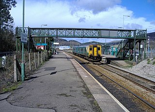
Hirwaun was a railway station serving the village of Hirwaun in Rhondda Cynon Taf, Wales.

Penderyn is a rural village in the Cynon Valley, Rhondda Cynon Taf, Wales, located near Hirwaun.
Aberdare East is a local government community and electoral ward in Rhondda Cynon Taf, Wales. The community was formed in 2016 when the former community of Aberdare was split into two. Aberdare East includes the main town of Aberdare.


