
The Little Colorado River is a tributary of the Colorado River in the U.S. state of Arizona, providing the principal drainage from the Painted Desert region. Together with its major tributary, the Puerco River, it drains an area of about 26,500 square miles (69,000 km2) in eastern Arizona and western New Mexico. Although it stretches almost 340 miles (550 km), only the headwaters and the lowermost reaches flow year-round. Between St. Johns and Cameron, most of the river is a wide, braided wash, only containing water after heavy snowmelt or flash flooding.

Pah-Ute County is a former county in the northwest corner of Arizona Territory that existed from 1865 until 1871, at which point most of the area was transferred to Nevada. The remainder was merged into Mohave County. The majority of the territory is now in Clark County, Nevada, which includes the city of Las Vegas. Due to the transfer of most of the county's land to Nevada, Pah-Ute is sometimes referred to as Arizona's "Lost County". Pah-Ute is a historic spelling of the tribal name Paiute.

St. Thomas, Nevada is a ghost town in Clark County, Nevada, United States, near where the Muddy River flows into the Colorado River. St. Thomas was purchased by the US Federal Government and abandoned as the waters of Lake Mead submerged the town in the 1930s.
The Muddy River, formerly known as the Moapa River, is a short river located in Clark County, in southern Nevada, United States. It is in the Mojave Desert, approximately 60 miles (97 km) north of Las Vegas.
The Black Mountains, a mid-Miocene formation, in Nevada are a series of rugged, arid rocky volcanic mountains ranging in elevations to 3310 ft. The range lies on the north shore of Lake Mead, at the southwest corner of the Overton Arm, about 25 mi south of Overton, Nevada.
Rioville, Nevada was a settlement founded by Latter-day Saints in what they thought was Utah Territory in 1869, now under Lake Mead and within Clark County, Nevada.

El Dorado Canyon is a canyon in southern Clark County, Nevada famed for its rich silver and gold mines. The canyon was named in 1857 by steamboat entrepreneur Captain George Alonzo Johnson when gold and silver was discovered here. It drains into the Colorado River at the former site of Nelson's Landing.

Callville Bay is a waterway on the northwestern side of Lake Mead in the U.S. state of Nevada. It has a marina and camping resort. Situated east of Las Vegas and upstream from Las Vegas Bay, it lies within the Lake Mead National Recreation Area, which was established in 1935. Its name derives from the settlement of Callville which was established in 1865 by Anson Call under a directive led by Brigham Young. Though the settlement was abandoned in 1869, and submerged under Lake Mead when the Colorado River was dammed, Callville Bay retained the name.

The Muddy Creek Formation is a geologic formation in Arizona, California, Nevada, and Utah. It preserves fossils dating back to the Neogene period.

Steamboats on the Colorado River operated from the river mouth at the Colorado River Delta on the Gulf of California in Mexico, up to the Virgin River on the Lower Colorado River Valley in the Southwestern United States from 1852 until 1909, when the construction of the Laguna Dam was completed. The shallow draft paddle steamers were found to be the most economical way to ship goods between the Pacific Ocean ports and settlements and mines along the lower river, putting in at landings in Sonora state, Baja California Territory, California state, Arizona Territory, New Mexico Territory, and Nevada state. They remained the primary means of transportation of freight until the advent of the more economical railroads began cutting away at their business from 1878 when the first line entered Arizona Territory.
Esmerelda, was a stern-wheel paddle-steamer, built for the Sacramento River trade, in 1864 it became the first of the opposition steamboats on the Colorado River. It was also the first steamboat to tow large cargo barges on that river, in May 1864 and to reach Callville, Nevada in 1866.
Ringbolt Rapids are a series of rapids in the upper Black Canyon of the Colorado, 12 miles above the Roaring Rapids in the Colorado River between Arizona and Nevada.
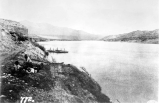
Bonelli's Ferry or Old Bonelli Ferry was a Colorado River ferry between Arizona and Nevada. It was located on the Colorado just above the Virgin River, near Junction City. The latter was later known as Rioville, Nevada in the late nineteenth century. Both the former sites of the ferry and of Rioville were submerged below Lake Mead, created by a dam on the Colorado River.
Stone's Ferry is a former settlement founded by members of the Church of Jesus Christ of Latter-day Saints and ferry crossing of the Colorado River between Nevada and Arizona, in Clark County, Nevada, United States.
Cottonwood Island, a large island in the Colorado River, within Cottonwood Valley, in Clark County, Nevada. Cottonwood Island was a low-lying island about 10 miles long and up to 3 miles wide. It was forested by cottonwoods and also after the spring flood, cluttered with driftwood from the riparian woodlands along the upper watershed of the Colorado River, washed down and caught in the first wide valley where the river slowed and spread out. Cottonwood Island was important as a source wood and of fuel for steamboats on that river and for the early mills and mines in El Dorado Canyon.
Gila, a stern-wheel steamboat of the Colorado Steam Navigation Company running on the Colorado River between 1873 and 1899.
George A. Johnson & Company was a partnership between three men who pioneered navigation on the Colorado River. Benjamin M. Hartshorne, George Alonzo Johnson and Alfred H. Wilcox. The George A. Johnson & Company was formed in the fall of 1852, and was reorganized as the Colorado Steam Navigation Company in 1869.
Mormon Road, also known to the 49ers as the Southern Route, of the California Trail in the Western United States, was a seasonal wagon road pioneered by a Mormon party from Salt Lake City, Utah led by Jefferson Hunt, that followed the route of Spanish explorers and the Old Spanish Trail across southwestern Utah, northwestern Arizona, southern Nevada and the Mojave Desert of California to Los Angeles in 1847. From 1855, it became a military and commercial wagon route between California and Utah, called the Los Angeles – Salt Lake Road. In later decades this route was variously called the "Old Mormon Road", the "Old Southern Road", or the "Immigrant Road" in California. In Utah, Arizona and Nevada it was known as the "California Road".
Callville Wash is an ephemeral stream or wash in Clark County, Nevada. It was named for Callville the riverport settlement founded in 1866, at its mouth where it had its original confluence with the Colorado River.
Rio Virgen County is a former county in the U.S. state of Utah. It was established by the Territory of Utah in February 1869.


