Carbondale, Kansas

Last updated

Carbondale, Kansas
Carbondale, Kansas.jpg
Downtown Carbondale (2005)
Osage County Kansas Incorporated and Unincorporated areas Carbondale Highlighted.svg
Location within Osage County and Kansas
Map of Osage Co, Ks, USA.png
Coordinates: 38°49′6″N95°41′30″W / 38.81833°N 95.69167°W / 38.81833; -95.69167 [1]
Country United States
State Kansas
County Osage
Founded1869
Incorporated 1872
Named for Carbon Coal Company
Area
[2]
  Total0.76 sq mi (1.95 km2)
  Land0.73 sq mi (1.89 km2)
  Water0.02 sq mi (0.06 km2)
Elevation
[1]
1,125 ft (343 m)
Population
 (2020) [3]
  Total1,352
  Density1,800/sq mi (690/km2)
Time zone UTC-6 (CST)
  Summer (DST) UTC-5 (CDT)
ZIP code
66414
Area code 785
FIPS code 20-10600 [1]
GNIS ID 479448 [1]
Website carbondaleks.com

Carbondale is a city in Osage County, Kansas, United States. [1] As of the 2020 census, the population of the city was 1,352. [3] It is located south of Topeka along U.S. Route 75 four lane freeway.

Contents

History

Carbondale was founded in 1869. It initially grew as a coal town of the Carbon Coal Company. [4] Coal is a carbon-based fuel, hence the name. [5]

From 1906 to 1908 the Daughters of the American Revolution of Kansas placed sixty-six markers along the path of the Santa Fe Trail as it ran through Kansas. Number seventeen is located in Carbondale.

Geography

Carbondale is located at 38°49′6″N95°41′30″W / 38.81833°N 95.69167°W / 38.81833; -95.69167 (38.818411, -95.691533). [6] It is the first city south of Topeka, Kansas on U.S. Highway 75. According to the United States Census Bureau, the city has a total area of 0.77 square miles (1.99 km2), of which, 0.75 square miles (1.94 km2) is land and 0.02 square miles (0.05 km2) is water. [7]

Demographics

Historical population
CensusPop.Note
1880 710
1890 84719.3%
1900 625−26.2%
1910 461−26.2%
1920 383−16.9%
1930 3994.2%
1940 4154.0%
1950 4539.2%
1960 66446.6%
1970 1,04156.8%
1980 1,51845.8%
1990 1,5260.5%
2000 1,478−3.1%
2010 1,437−2.8%
2020 1,352−5.9%
U.S. Decennial Census

Carbondale is part of the Topeka, Kansas Metropolitan Statistical Area.

2020 census

The 2020 United States census counted 1,352 people, 578 households, and 350 families in Carbondale. [8] [9] The population density was 1,849.5 per square mile (714.1/km2). There were 622 housing units at an average density of 850.9 per square mile (328.5/km2). [9] [10] The racial makeup was 91.64% (1,239) white or European American (89.05% non-Hispanic white), 0.15% (2) black or African-American, 0.15% (2) Native American or Alaska Native, 0.81% (11) Asian, 0.0% (0) Pacific Islander or Native Hawaiian, 0.67% (9) from other races, and 6.58% (89) from two or more races. [11] Hispanic or Latino of any race was 4.36% (59) of the population. [12]

Of the 578 households, 31.7% had children under the age of 18; 40.5% were married couples living together; 34.1% had a female householder with no spouse or partner present. 33.2% of households consisted of individuals and 16.4% had someone living alone who was 65 years of age or older. [9] The average household size was 2.4 and the average family size was 2.7. [13] The percent of those with a bachelor’s degree or higher was estimated to be 7.8% of the population. [14]

25.5% of the population was under the age of 18, 7.1% from 18 to 24, 25.7% from 25 to 44, 25.7% from 45 to 64, and 15.9% who were 65 years of age or older. The median age was 37.7 years. For every 100 females, there were 106.7 males. [9] For every 100 females ages 18 and older, there were 112.4 males. [9]

The 2016-2020 5-year American Community Survey estimates show that the median household income was $60,938 (with a margin of error of +/- $8,960) and the median family income was $72,250 (+/- $13,834). [15] Males had a median income of $40,521 (+/- $10,374) versus $24,265 (+/- $4,021) for females. The median income for those above 16 years old was $30,878 (+/- $5,092). [16] Approximately, 9.4% of families and 12.0% of the population were below the poverty line, including 15.7% of those under the age of 18 and 15.8% of those ages 65 or over. [17] [18]

2010 census

As of the census [19] of 2010, there were 1,437 people, 590 households, and 385 families residing in the city. The population density was 1,916.0 inhabitants per square mile (739.8/km2). There were 637 housing units at an average density of 849.3 per square mile (327.9/km2). The racial makeup of the city was 95.8% White, 0.3% African American, 1.2% Native American, 0.2% Asian, 0.1% Pacific Islander, 0.3% from other races, and 2.1% from two or more races. Hispanic or Latino of any race were 2.9% of the population.

There were 590 households, of which 34.6% had children under the age of 18 living with them, 45.1% were married couples living together, 14.1% had a female householder with no husband present, 6.1% had a male householder with no wife present, and 34.7% were non-families. 29.7% of all households were made up of individuals, and 11.8% had someone living alone who was 65 years of age or older. The average household size was 2.44 and the average family size was 3.00.

The median age in the city was 34.3 years. 26.5% of residents were under the age of 18; 10.7% were between the ages of 18 and 24; 23.2% were from 25 to 44; 26.4% were from 45 to 64; and 13.2% were 65 years of age or older. The gender makeup of the city was 50.0% male and 50.0% female.

2000 census

As of the census [20] of 2000, there were 1,478 people, 581 households, and 393 families residing in the city. The population density was 2,020.0 inhabitants per square mile (779.9/km2). There were 617 housing units at an average density of 843.3 per square mile (325.6/km2). The racial makeup of the city was 96.75% White, 0.27% African American, 0.54% Native American, 0.07% Asian, 0.07% Pacific Islander, 0.54% from other races, and 1.76% from two or more races. Hispanic or Latino of any race were 3.79% of the population.

There were 581 households, out of which 41.1% had children under the age of 18 living with them, 50.1% were married couples living together, 13.8% had a female householder with no husband present, and 32.2% were non-families. 28.2% of all households were made up of individuals, and 11.5% had someone living alone who was 65 years of age or older. The average household size was 2.54 and the average family size was 3.16.

In the city, the population was spread out, with 32.0% under the age of 18, 9.3% from 18 to 24, 29.5% from 25 to 44, 19.4% from 45 to 64, and 9.8% who were 65 years of age or older. The median age was 33 years. For every 100 females, there were 89.7 males. For every 100 females age 18 and over, there were 82.7 males.

The median income for a household in the city was $31,550, and the median income for a family was $39,226. Males had a median income of $29,226 versus $21,300 for females. The per capita income for the city was $14,729. About 9.8% of families and 11.1% of the population were below the poverty line, including 13.4% of those under age 18 and 11.5% of those age 65 or over.

Government

The Carbondale City Library is located inside the City building in Carbondale, Kansas. The library opened in 1971 and is a member of the Northeast Kansas Library System, NEKLS. The library has a wide selection of children's and adult books. They have an extensive collection of large print books. The library also boasts a selection of audiobooks on tape and compact disc. The library has patron computers with a wide variety of programs and free use of the internet. The library also has a Friends of the Library organization which meets monthly.

Education

Carbondale is served by USD 434 Santa Fe Trail. USD 434 includes Carbondale, Scranton and Overbrook. The Carbondale attendance center houses grades K-8. The district high school is Santa Fe Trail High School. [21]

The Santa Fe Trail Chargers won the Kansas State High School boys class 4A basketball championship in 1997 and the girls class 4A basketball championship in 1998. [22]

Carbondale High School was closed through school unification. The Carbondale Vikings [23] won the Kansas State High School boys class B basketball championship in 1951. [22]

Notable people

Related Research Articles

<span class="mw-page-title-main">Muscotah, Kansas</span> City in Kansas, United States

Muscotah is a city in Atchison County, Kansas, United States. As of the 2020 census, the population of the city was 155. Muscotah was named after the Kickapoo Native American word for "prairie".

<span class="mw-page-title-main">Horton, Kansas</span> City in Brown County, Kansas

Horton is a city in Brown County, Kansas, United States. As of the 2020 census, the population of the city was 1,523.

<span class="mw-page-title-main">Reserve, Kansas</span> City in Brown County, Kansas

Reserve is a city in Brown County, Kansas, United States. As of the 2020 census, the population of the city was 67. It is located approximately 1.5 miles south of the Nebraska-Kansas border.

<span class="mw-page-title-main">Peru, Kansas</span> City in Chautauqua County, Kansas

Peru is a city in Chautauqua County, Kansas, United States. As of the 2020 census, the population of the city was 101.

<span class="mw-page-title-main">Gridley, Kansas</span> City in Coffey County, Kansas

Gridley is a city in Coffey County, Kansas, United States. As of the 2020 census, the population of the city was 313.

<span class="mw-page-title-main">Gove City, Kansas</span> City in Gove County, Kansas

Gove City, more commonly known as Gove, is a city in and the county seat of Gove County, Kansas, United States. As of the 2020 census, the population of the city was 80.

<span class="mw-page-title-main">Axtell, Kansas</span> City in Marshall County, Kansas

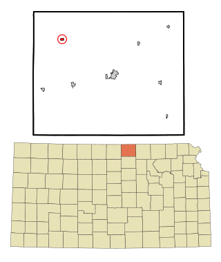
Axtell is a city in Marshall County, Kansas, United States. As of the 2020 census, the population of the city was 399.

<span class="mw-page-title-main">Ness City, Kansas</span> City in Ness County, Kansas

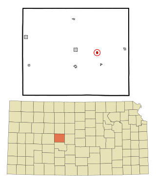
Ness City is a city in and the county seat of Ness County, Kansas, United States. As of the 2020 census, the population of the city was 1,329. Ness City is famous for its four-story Old Ness County Bank Building located downtown, and nicknamed Skyscraper of the Plains.

<span class="mw-page-title-main">Overbrook, Kansas</span> City in Osage County, Kansas

Overbrook is a city in Osage County, Kansas, United States. As of the 2020 census, the population of the city was 1,005.

<span class="mw-page-title-main">Agra, Kansas</span> City in Phillips County, Kansas

Agra is a city in Phillips County, Kansas, United States. As of the 2020 census, the population of the city was 208.

<span class="mw-page-title-main">Kirwin, Kansas</span> City in Phillips County, Kansas

Kirwin is a city in Phillips County, Kansas, United States. As of the 2020 census, the population of the city was 139.

<span class="mw-page-title-main">Atwood, Kansas</span> City in Rawlins County, Kansas

Atwood is a city in and the county seat of Rawlins County, Kansas, United States. As of the 2020 census, the population of the city was 1,290.

<span class="mw-page-title-main">Belleville, Kansas</span> City in Republic County, Kansas

Belleville is a city in and the county seat of Republic County, Kansas, United States. As of the 2020 census, the population of the city was 2,007.

<span class="mw-page-title-main">Munden, Kansas</span> City in Republic County, Kansas

Munden is a city in Republic County, Kansas, United States. As of the 2020 census, the population of the city was 96.

<span class="mw-page-title-main">Narka, Kansas</span> City in Republic County, Kansas

Narka is a city in Republic County, Kansas, United States. As of the 2020 census, the population of the city was 81.

<span class="mw-page-title-main">Republic, Kansas</span> City in Republic County, Kansas, United States

Republic is a city in Republic County, Kansas, United States. As of the 2020 census, the population of the city was 82.

<span class="mw-page-title-main">Bison, Kansas</span> City in Rush County, Kansas

Bison is a city in Rush County, Kansas, United States. As of the 2020 census, the population of the city was 179.

<span class="mw-page-title-main">Kensington, Kansas</span> City in Smith County, Kansas

Kensington is a city in Smith County, Kansas, United States. As of the 2020 census, the population of the city was 399.

<span class="mw-page-title-main">Haddam, Kansas</span> City in Washington County, Kansas

Haddam is a city in Washington County, Kansas, United States. It is named after Haddam, Connecticut. As of the 2020 census, the population of the city was 110.

<span class="mw-page-title-main">Clayton, Kansas</span> City in Decatur and Norton Counties of Kansas

Clayton is a city in Decatur and Norton counties in the U.S. state of Kansas. As of the 2020 census, the population of the city was 44.

References

  1. 1 2 3 4 5 "Carbondale, Kansas", Geographic Names Information System , United States Geological Survey, United States Department of the Interior
  2. "2019 U.S. Gazetteer Files". United States Census Bureau. Retrieved July 24, 2020.
  3. 1 2 "Profile of Carbondale, Kansas in 2020". United States Census Bureau. Archived from the original on June 4, 2022. Retrieved June 4, 2022.
  4. Blackmar, Frank Wilson (1912). Kansas: A Cyclopedia of State History, Embracing Events, Institutions, Industries, Counties, Cities, Towns, Prominent Persons, Etc. Standard Publishing Company. pp.  287.
  5. Kansas State Historical Society (1916). Biennial Report of the Board of Directors of the Kansas State Historical Society. Kansas State Printing Plant. pp.  255.
  6. "US Gazetteer files: 2010, 2000, and 1990". United States Census Bureau. February 12, 2011. Retrieved April 23, 2011.
  7. "US Gazetteer files 2010". United States Census Bureau. Archived from the original on July 2, 2012. Retrieved July 6, 2012.
  8. "US Census Bureau, Table P16: HOUSEHOLD TYPE". data.census.gov. Retrieved January 2, 2024.
  9. 1 2 3 4 5 "US Census Bureau, Table DP1: PROFILE OF GENERAL POPULATION AND HOUSING CHARACTERISTICS". data.census.gov. Retrieved January 2, 2024.
  10. Bureau, US Census. "Gazetteer Files". Census.gov. Retrieved December 30, 2023.
  11. "US Census Bureau, Table P1: RACE". data.census.gov. Retrieved January 2, 2024.
  12. "US Census Bureau, Table P2: HISPANIC OR LATINO, AND NOT HISPANIC OR LATINO BY RACE". data.census.gov. Retrieved January 2, 2024.
  13. "US Census Bureau, Table S1101: HOUSEHOLDS AND FAMILIES". data.census.gov. Retrieved January 2, 2024.
  14. "US Census Bureau, Table S1501: EDUCATIONAL ATTAINMENT". data.census.gov. Retrieved January 2, 2024.
  15. "US Census Bureau, Table S1903: MEDIAN INCOME IN THE PAST 12 MONTHS (IN 2020 INFLATION-ADJUSTED DOLLARS)". data.census.gov. Retrieved January 2, 2024.
  16. "US Census Bureau, Table S2001: EARNINGS IN THE PAST 12 MONTHS (IN 2020 INFLATION-ADJUSTED DOLLARS)". data.census.gov. Retrieved January 2, 2024.
  17. "US Census Bureau, Table S1701: POVERTY STATUS IN THE PAST 12 MONTHS". data.census.gov. Retrieved January 2, 2024.
  18. "US Census Bureau, Table S1702: POVERTY STATUS IN THE PAST 12 MONTHS OF FAMILIES". data.census.gov. Retrieved January 2, 2024.
  19. "U.S. Census website". United States Census Bureau . Retrieved July 6, 2012.
  20. "U.S. Census website". United States Census Bureau . Retrieved January 31, 2008.
  21. "Santa Fe Trail USD 434". USD 434. Retrieved January 5, 2010.
  22. 1 2 "Basketball". KSHSAA. Archived from the original on January 2, 2017. Retrieved January 3, 2017.
  23. "Carbondale Cops State Class B Title", The Hutchinson News, 18 March 1951, p.17.

Further reading