Melvern, Kansas

Last updated

Melvern, Kansas
Osage County Kansas Incorporated and Unincorporated areas Melvern Highlighted.svg
Location within Osage County and Kansas
Map of Osage Co, Ks, USA.png
Coordinates: 38°30′27″N95°38′18″W / 38.50750°N 95.63833°W / 38.50750; -95.63833 [1]
Country United States
State Kansas
County Osage
Founded1870
Platted 1870
Incorporated 1883
Named for Malvern Hills
Area
[2]
  Total0.36 sq mi (0.92 km2)
  Land0.36 sq mi (0.92 km2)
  Water0.00 sq mi (0.00 km2)
Elevation
[1]
1,017 ft (310 m)
Population
 (2020) [3]
  Total356
  Density990/sq mi (390/km2)
Time zone UTC-6 (CST)
  Summer (DST) UTC-5 (CDT)
ZIP code
66510
Area code 785
FIPS code 20-45700 [1]
GNIS ID 477555 [1]
Website City webpage

Melvern is a city in Osage County, Kansas, United States, [1] along the Marais des Cygnes River. As of the 2020 census, the population of the city was 356. [3]

Contents

History

Melvern was laid out in 1870. [4] It was named after the Malvern Hills, in Worcestershire, England. [5] [6] [7]

The first post office in Melvern was established in June 1870. [8]

Geography

Melvern is located at 38°30′27″N95°38′18″W / 38.50750°N 95.63833°W / 38.50750; -95.63833 (38.507446, -95.638332). [9] According to the United States Census Bureau, the city has a total area of 0.35 square miles (0.91 km2), all land. [10]

Demographics

Historical population
CensusPop.Note
1880 103
1890 461347.6%
1900 4691.7%
1910 5057.7%
1920 422−16.4%
1930 4455.5%
1940 368−17.3%
1950 3895.7%
1960 376−3.3%
1970 45521.0%
1980 4815.7%
1990 423−12.1%
2000 4291.4%
2010 385−10.3%
2020 356−7.5%
U.S. Decennial Census

Melvern is part of the Topeka, Kansas Metropolitan Statistical Area.

2020 census

The 2020 United States census counted 356 people, 151 households, and 92 families in Melvern. [11] [12] The population density was 1,000.0 per square mile (386.1/km2). There were 180 housing units at an average density of 505.6 per square mile (195.2/km2). [12] [13] The racial makeup was 91.57% (326) white or European American (91.01% non-Hispanic white), 0.28% (1) black or African-American, 0.56% (2) Native American or Alaska Native, 0.0% (0) Asian, 0.0% (0) Pacific Islander or Native Hawaiian, 0.84% (3) from other races, and 6.74% (24) from two or more races. [14] Hispanic or Latino of any race was 1.69% (6) of the population. [15]

Of the 151 households, 32.5% had children under the age of 18; 38.4% were married couples living together; 27.8% had a female householder with no spouse or partner present. 30.5% of households consisted of individuals and 17.2% had someone living alone who was 65 years of age or older. [12] The average household size was 2.5 and the average family size was 2.9. [16] The percent of those with a bachelor’s degree or higher was estimated to be 9.3% of the population. [17]

25.6% of the population was under the age of 18, 8.7% from 18 to 24, 21.1% from 25 to 44, 24.2% from 45 to 64, and 20.5% who were 65 years of age or older. The median age was 38.7 years. For every 100 females, there were 110.7 males. [12] For every 100 females ages 18 and older, there were 105.4 males. [12]

The 2016-2020 5-year American Community Survey estimates show that the median household income was $45,938 (with a margin of error of +/- $14,323) and the median family income was $51,042 (+/- $11,061). [18] Males had a median income of $33,281 (+/- $14,979) versus $23,125 (+/- $10,185) for females. The median income for those above 16 years old was $30,714 (+/- $12,634). [19] Approximately, 12.0% of families and 19.3% of the population were below the poverty line, including 19.1% of those under the age of 18 and 11.1% of those ages 65 or over. [20] [21]

2010 census

As of the census [22] of 2010, there were 385 people, 159 households, and 109 families living in the city. The population density was 1,100.0 inhabitants per square mile (424.7/km2). There were 184 housing units at an average density of 525.7 per square mile (203.0/km2). The racial makeup of the city was 96.6% White, 0.3% African American, 0.8% Asian, 0.3% from other races, and 2.1% from two or more races. Hispanic or Latino of any race were 2.3% of the population.

There were 159 households, of which 30.8% had children under the age of 18 living with them, 52.2% were married couples living together, 8.8% had a female householder with no husband present, 7.5% had a male householder with no wife present, and 31.4% were non-families. 27.0% of all households were made up of individuals, and 10% had someone living alone who was 65 years of age or older. The average household size was 2.39 and the average family size was 2.86.

The median age in the city was 40.8 years. 24.7% of residents were under the age of 18; 6% were between the ages of 18 and 24; 25.2% were from 25 to 44; 24.9% were from 45 to 64; and 19.2% were 65 years of age or older. The gender makeup of the city was 48.6% male and 51.4% female.

2000 census

As of the census [23] of 2000, there were 429 people, 173 households, and 120 families living in the city. The population density was 1,297.3 inhabitants per square mile (500.9/km2). There were 202 housing units at an average density of 610.9 per square mile (235.9/km2). The racial makeup of the city was 98.14% White, 0.70% Native American, 0.23% from other races, and 0.93% from two or more races. Hispanic or Latino of any race were 0.93% of the population.

There were 173 households, out of which 31.8% had children under the age of 18 living with them, 56.1% were married couples living together, 10.4% had a female householder with no husband present, and 30.6% were non-families. 28.9% of all households were made up of individuals, and 14.5% had someone living alone who was 65 years of age or older. The average household size was 2.47 and the average family size was 3.00.

In the city, the population was spread out, with 26.3% under the age of 18, 6.8% from 18 to 24, 28.9% from 25 to 44, 17.9% from 45 to 64, and 20.0% who were 65 years of age or older. The median age was 37 years. For every 100 females, there were 98.6 males. For every 100 females age 18 and over, there were 85.9 males.

The median income for a household in the city was $32,321, and the median income for a family was $50,833. Males had a median income of $30,313 versus $17,143 for females. The per capita income for the city was $16,206. About 5.3% of families and 9.2% of the population were below the poverty line, including 4.5% of those under age 18 and 9.2% of those age 65 or over.

Education

The community is served by Marais des Cygnes Valley USD 456 public school district. The district high school is Marais des Cygnes Valley High School. Mascot is Trojans. [24]

Prior to school unification, the Melvern High School mascot was Panthers. The Melvern Panthers won the Kansas State High School boys class B basketball championship in 1962. [25]

Parks and Recreation

Related Research Articles

<span class="mw-page-title-main">Hepler, Kansas</span> City in Crawford County, Kansas

Hepler is a city in Crawford County, Kansas, United States. As of the 2020 census, the population of the city was 90.

<span class="mw-page-title-main">Mulberry, Kansas</span> City in Crawford County, Kansas

Mulberry is a city in Crawford County, Kansas, United States. As of the 2020 census, the population of the city was 409.

<span class="mw-page-title-main">Jennings, Kansas</span> City in Decatur County, Kansas

Jennings is a city in Decatur County, Kansas, United States. As of the 2020 census, the population of the city was 81.

<span class="mw-page-title-main">Norcatur, Kansas</span> City in Decatur County, Kansas

Norcatur is a city in Decatur County, Kansas, United States. As of the 2020 census, the population of the city was 159.

<span class="mw-page-title-main">Ottawa, Kansas</span> City in Franklin County, Kansas

Ottawa is a city in, and the county seat of, Franklin County, Kansas, United States. It is located on both banks of the Marais des Cygnes River near the center of Franklin County. As of the 2020 census, the population of the city was 12,625. It is the home of Ottawa University.

<span class="mw-page-title-main">Gove City, Kansas</span> City in Gove County, Kansas

Gove City, more commonly known as Gove, is a city in and the county seat of Gove County, Kansas, United States. As of the 2020 census, the population of the city was 80.

<span class="mw-page-title-main">Randall, Kansas</span> City in Jewell County, Kansas

Randall is a city in Jewell County, Kansas, United States. As of the 2020 census, the population of the city was 79.

<span class="mw-page-title-main">La Cygne, Kansas</span> City in Kansas, United States

La Cygne is a city in Linn County, Kansas, United States, and situated along the Marais des Cygnes River. As of the 2020 census, the population of the city was 1,050. The city is named after the Marais des Cygnes River which is a French translation of an Osage appellation meaning "marsh of the swans".

<span class="mw-page-title-main">Meade, Kansas</span> City in Meade County, Kansas

Meade is a city in and the county seat of Meade County, Kansas, United States. As of the 2020 census, the population of the city was 1,505.

<span class="mw-page-title-main">Fontana, Kansas</span> City in Kansas, United States

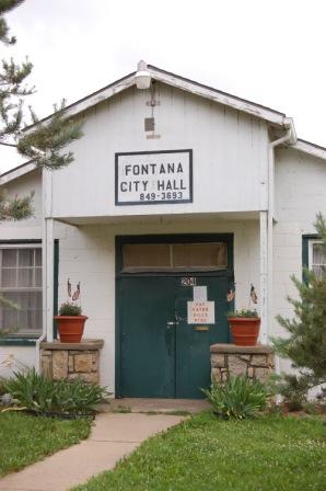
Fontana is a city in south central Miami County, Kansas, United States, and is part of the Kansas City metropolitan area. As of the 2020 census, the population of the city was 210. The name Fontana comes from the French word fontaine, meaning fountain or a spring-like water source. It was given to the small city from a spring near the town site.

<span class="mw-page-title-main">Osawatomie, Kansas</span> City in Kansas, United States

Osawatomie is a city in Miami County, Kansas, United States, 61 miles (98 km) southwest of Kansas City. As of the 2020 census, the population of the city was 4,255. It derives its name as a portmanteau of two nearby streams, the Marais des Cygnes River and Pottawatomie Creek.

<span class="mw-page-title-main">Ness City, Kansas</span> City in Ness County, Kansas

Ness City is a city in and the county seat of Ness County, Kansas, United States. As of the 2020 census, the population of the city was 1,329. Ness City is famous for its four-story Old Ness County Bank Building located downtown, and nicknamed Skyscraper of the Plains.

<span class="mw-page-title-main">Lyndon, Kansas</span> City in Osage County, Kansas

Lyndon is a city in, and the county seat of Osage County, Kansas, United States. As of the 2020 census, the population of the city was 1,037.

<span class="mw-page-title-main">Olivet, Kansas</span> City in Osage County, Kansas

Olivet is a city in Osage County, Kansas, United States. As of the 2020 census, the population of the city was 73. It is located near the south side of Melvern Lake.

<span class="mw-page-title-main">Quenemo, Kansas</span> City in Osage County, Kansas

Quenemo is a city in Osage County, Kansas, United States, along the Marais des Cygnes River. As of the 2020 census, the population of the city was 288.

<span class="mw-page-title-main">Minneapolis, Kansas</span> City in Ottawa County, Kansas

Minneapolis is a city in and the county seat of Ottawa County, Kansas, United States. As of the 2020 census, the population of the city was 1,946.

<span class="mw-page-title-main">Belleville, Kansas</span> City in Republic County, Kansas

Belleville is a city in and the county seat of Republic County, Kansas, United States. As of the 2020 census, the population of the city was 2,007.

<span class="mw-page-title-main">Munden, Kansas</span> City in Republic County, Kansas

Munden is a city in Republic County, Kansas, United States. As of the 2020 census, the population of the city was 96.

<span class="mw-page-title-main">Mount Hope, Kansas</span> City in Sedgwick County, Kansas

Mount Hope is a city in Sedgwick County, Kansas, United States. As of the 2020 census, the population of the city was 806.

<span class="mw-page-title-main">Lebo, Kansas</span> City in Coffey County, Kansas

Lebo is a city in Coffey County, Kansas, United States. As of the 2020 census, the population of the city was 885.

References

  1. 1 2 3 4 5 "Melvern, Kansas", Geographic Names Information System , United States Geological Survey, United States Department of the Interior
  2. "2019 U.S. Gazetteer Files". United States Census Bureau. Retrieved July 24, 2020.
  3. 1 2 "Profile of Melvern, Kansas in 2020". United States Census Bureau. Archived from the original on June 4, 2022. Retrieved June 4, 2022.
  4. Blackmar, Frank Wilson (1912). Kansas: A Cyclopedia of State History, Volume 2. Standard Publishing Company. pp.  265.
  5. Kansas State Historical Society (1916). Biennial Report of the Board of Directors of the Kansas State Historical Society. Kansas State Printing Plant. pp.  255.
  6. Capace, Nancy (2000). Encyclopedia of Kansas. Somerset Publishers. p. 235. ISBN   9780403093120.
  7. Gannett, Henry (1905). The Origin of Certain Place Names in the United States. U.S. Government Printing Office. p.  204.
  8. "Kansas Post Offices, 1828-1961". Kansas Historical Society. Archived from the original on October 9, 2013. Retrieved June 22, 2014.
  9. "US Gazetteer files: 2010, 2000, and 1990". United States Census Bureau. February 12, 2011. Retrieved April 23, 2011.
  10. "US Gazetteer files 2010". United States Census Bureau. Archived from the original on July 2, 2012. Retrieved July 6, 2012.
  11. "US Census Bureau, Table P16: HOUSEHOLD TYPE". data.census.gov. Retrieved January 3, 2024.
  12. 1 2 3 4 5 "US Census Bureau, Table DP1: PROFILE OF GENERAL POPULATION AND HOUSING CHARACTERISTICS". data.census.gov. Retrieved January 3, 2024.
  13. Bureau, US Census. "Gazetteer Files". Census.gov. Retrieved December 30, 2023.
  14. "US Census Bureau, Table P1: RACE". data.census.gov. Retrieved January 3, 2024.
  15. "US Census Bureau, Table P2: HISPANIC OR LATINO, AND NOT HISPANIC OR LATINO BY RACE". data.census.gov. Retrieved January 3, 2024.
  16. "US Census Bureau, Table S1101: HOUSEHOLDS AND FAMILIES". data.census.gov. Retrieved January 3, 2024.
  17. "US Census Bureau, Table S1501: EDUCATIONAL ATTAINMENT". data.census.gov. Retrieved January 3, 2024.
  18. "US Census Bureau, Table S1903: MEDIAN INCOME IN THE PAST 12 MONTHS (IN 2020 INFLATION-ADJUSTED DOLLARS)". data.census.gov. Retrieved January 3, 2024.
  19. "US Census Bureau, Table S2001: EARNINGS IN THE PAST 12 MONTHS (IN 2020 INFLATION-ADJUSTED DOLLARS)". data.census.gov. Retrieved January 3, 2024.
  20. "US Census Bureau, Table S1701: POVERTY STATUS IN THE PAST 12 MONTHS". data.census.gov. Retrieved January 3, 2024.
  21. "US Census Bureau, Table S1702: POVERTY STATUS IN THE PAST 12 MONTHS OF FAMILIES". data.census.gov. Retrieved January 3, 2024.
  22. "U.S. Census website". United States Census Bureau . Retrieved July 6, 2012.
  23. "U.S. Census website". United States Census Bureau . Retrieved January 31, 2008.
  24. "Marais des Cygnes Valley USD 456". USD 456. Retrieved January 5, 2017.
  25. "Basketball". KSHSAA. Retrieved January 3, 2017.

Further reading