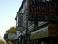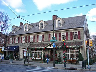
Chestnut Hill is a neighborhood in the Northwest Philadelphia section of Philadelphia, Pennsylvania, United States. It is known for the high incomes of its residents and high real estate values, as well as its private schools.
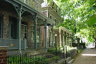
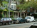
Powelton Village is a neighborhood of mostly Victorian, mostly twin homes in the West Philadelphia section of the United States city of Philadelphia, Pennsylvania. It is a national historic district that is part of University City. Powelton Village extends north from Market Street to Spring Garden Street, east to 32nd Street, west to 40th and Spring Garden Streets, and to 44th and Market Streets.
A streetcar suburb is a residential community whose growth and development was strongly shaped by the use of streetcar lines as a primary means of transportation. Such suburbs developed in the United States in the years before the automobile, when the introduction of the electric trolley or streetcar allowed the nation’s burgeoning middle class to move beyond the central city’s borders. Early suburbs were served by horsecars, but by the late 19th century cable cars and electric streetcars, or trams, were used, allowing residences to be built farther away from the urban core of a city. Streetcar suburbs, usually called additions or extensions at the time, were the forerunner of today's suburbs in the United States and Canada. San Francisco's Western Addition is one of the best examples of streetcar suburbs before westward and southward expansion occurred.

University City is the easternmost portion of West Philadelphia, encompassing several Philadelphia universities. It is situated directly across the Schuylkill River from Center City.

West Philadelphia, nicknamed West Philly, is a section of the city of Philadelphia. Alhough there are no officially defined boundaries, it is generally considered to reach from the western shore of the Schuylkill River, to City Avenue to the northwest, Cobbs Creek to the southwest, and the SEPTA Media/Wawa Line to the south. An alternate definition includes all city land west of the Schuylkill; this would also include Southwest Philadelphia and its neighborhoods. The eastern side of West Philadelphia is also known as University City.
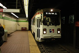
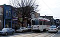
The SEPTA subway–surface trolley lines are a collection of five SEPTA trolley lines that operate on street-level tracks in West Philadelphia and Delaware County, Pennsylvania, and also underneath Market Street in Philadelphia's Center City. The lines, Routes 10, 11, 13, 34, and 36, collectively operate on about 39.6 miles (63.7 km) of route.
West Oak Lane is a neighborhood in the Northwest Philadelphia, Pennsylvania, United States. The neighborhood was developed primarily between the early 1920s and late 1930s, with the areas near to Cedarbrook constructed after World War II. At the northeast corner of Limekiln Pike and Washington Lane was the site of the Cedar Park Inn, a historic tavern built in the early 19th century, which was torn down sometime after 1931 as the neighborhood was being fully developed.

Route 11, also known as the Woodland Avenue Line, is a trolley line operated by the Southeastern Pennsylvania Transportation Authority (SEPTA) that connects the 13th Street station in downtown Philadelphia, Pennsylvania, to Darby Transportation Center in Darby, Pennsylvania. It is one of five lines that are part of the subway–surface trolley system. Sitting at an average of 13,580 riders per weekday in 2019, it is the most used subway-surface trolley route, even though it lacks overnight service.

SEPTA's subway–surface trolley route 34, also called the Baltimore Avenue subway line, is a trolley line operated by the Southeastern Pennsylvania Transportation Authority (SEPTA) that connects the 13th Street station in downtown Philadelphia, Pennsylvania, to the Angora Loop station in the Angora neighborhood of West Philadelphia.
Spruce Hill is a neighborhood in the University City section of West Philadelphia, Pennsylvania, United States. It is between 40th and 46th streets, and it stretches from Market Street south to Woodland Avenue. With a population of over 16,000, it is a racially and ethnically diverse part of the city where much historic architecture is preserved. The neighborhood contains a large number of Victorian rowhouses, many of which have been converted to multi-family apartments.
The Baltimore Pike was an auto trail connecting Baltimore, Maryland, with Philadelphia, Pennsylvania.

Southwest Philadelphia is a section of Philadelphia, Pennsylvania, United States. The section can be described as extending from the western side of the Schuylkill River to the city line, with the SEPTA. The northern border is defined by the Philadelphia City Planning Commission as east from the city line along Baltimore Avenue moving south along 51st Street to Springfield Ave. It follows the train tracks until 49th Street. From 49th and Kingsessing Ave the line moves east along Kingsessing Ave. The line then moves south along 46th St to Paschall Ave where it jogs to join Grays Ferry where the line runs to the Schuylkill River.

Angora is a neighborhood in the Southwest section of Philadelphia, Pennsylvania, United States. Although its boundaries are not precise, West Philadelphia is to its north, Kingsessing is to the south, Cedar Park is to the east, and Cobbs Creek is to the west. The Angora Commuter Rail Station on the Media/Wawa Line, two bus lines, and a trolley line all intersect around Baltimore Avenue and 58th Street, which is unofficially the nexus of the neighborhood.

Park Heights is an area of Baltimore City, Maryland, that lies approximately 10 miles northwest of downtown Baltimore and within two miles of the Baltimore County line. A 1,500-acre community, Park Heights comprises 12 smaller neighborhoods that together contain approximately 30,000 residents. It is bounded on the south by Druid Park Drive, on the west by Wabash Avenue, on the east by Greenspring Avenue, and on the north by Northern Parkway. Interstate-83 is less than a half mile to the east. Two major roadways—Park Heights Avenue and Reisterstown Road—run north-south through Park Heights, serving as the neighborhood's "Main Streets" as well as commuter corridors. Limited commercial uses—primarily retail—are scattered along these roads; there is also some industrial activity on the neighborhood's western edge.

The West Philadelphia Streetcar Suburb Historic District is an area of West Philadelphia listed on the National Register of Historic Places. It represented the transformation of Philadelphia's rural farmland into urban residential development, made possible by the streetcar, which provided easy access to Center City. This is an early example of the streetcar suburb.

U.S. Route 13 (US 13) is a United States Numbered Highway running from Fayetteville, North Carolina, north to Morrisville, Pennsylvania. The route runs for 49.359 miles (79.436 km) through the Delaware Valley in the U.S. state of Pennsylvania. The route enters the state from Delaware in Marcus Hook, Delaware County. It continues northeast through Delaware County, passing through the city of Chester before heading through suburban areas along Chester Pike to Darby. US 13 enters the city of Philadelphia on Baltimore Avenue and runs through West Philadelphia to University City, where it turns north along several city streets before heading east across the Schuylkill River along Girard Avenue. The route turns north and heads to North Philadelphia, where it runs northeast along Hunting Park Avenue. US 13 becomes concurrent with US 1 on Roosevelt Boulevard, continuing into Northeast Philadelphia. US 13 splits southeast on a one-way pair of streets before heading northeast out of the city on Frankford Avenue. The route continues into Bucks County as Bristol Pike, heading northeast to Bristol, where it turns into a divided highway. US 13 becomes a freeway in Tullytown and continues north to its terminus at US 1 in Falls Township, near Morrisville. US 13 roughly parallels Interstate 95 (I-95) through its course in Pennsylvania.

Carroll Park is a neighborhood in West Philadelphia, Pennsylvania, United States. Its boundaries are Lansdowne Avenue to the north, West Girard Avenue to the south, North 63rd Street to the west, and North 52nd Street to the east. Along major streets of the neighborhood, the Carroll Park Community Council, Inc. has placed banners that say “Carroll Park: Where our neighbors become friends.” The 10 trolley runs along Lansdowne Avenue and the 15 trolley runs along Girard Avenue. There is a park by the name of Carroll Park between North 59th and North 58th Streets and West Thompson Street and West Girard Avenue. Carroll Park’s residents are primarily working-class and lower-income African-Americans.

Patterson Park is a neighborhood in Baltimore, Maryland, United States. Named for the 137-acre park that abuts its north and east sides, the neighborhood is in the southeast section of Baltimore city, roughly two miles east of Baltimore's downtown district.
Olde Richmond is a neighborhood in the River Wards section of Philadelphia, Pennsylvania, United Sttes. It is notable for its historically large Polish immigrant, Polish American community, and Irish American community. The U.S. ZIP Code for Olde Richmond is 19125 and its post office is located at 1602 Frankford Avenue.