
The Broad Street Line (BSL), also known as the Broad Street subway (BSS), Orange Line, or Broad Line, is a subway line owned by the city of Philadelphia and operated by the Southeastern Pennsylvania Transportation Authority (SEPTA). The line runs primarily north-south from the Fern Rock Transportation Center in North Philadelphia through Center City Philadelphia to NRG station at Pattison Avenue in South Philadelphia; the latter station provides access to the stadiums and arenas for the city's major professional sports teams at the South Philadelphia Sports Complex, about a quarter mile away. It is named for Broad Street, under which the line runs for almost its entire length. In 2024, as part of the SEPTA Metro plan, the Broad Street Line is expected to be renamed the B Line.

Fairmount is a neighborhood within Lower North Philadelphia, Pennsylvania, United States. Its boundaries are north of Fairmount Avenue, west of Corinthian Avenue, south of Girard Avenue and east of The Schuylkill River. While this may be the most accurate demarcation, the area's boundaries fluctuate depending how the neighborhood is defined. Several other neighborhoods near Fairmount are sometimes also collectively called Fairmount, including: Spring Garden, Franklintown and Francisville. Fairmount and neighboring Spring Garden are commonly referred to as the "Art Museum Area," for their proximity to and association with the Philadelphia Museum of Art. Fairmount is also the location of the Eastern State Penitentiary.

The Schuylkill Expressway, locally known as "the Schuylkill", is a freeway through southern Montgomery County and Philadelphia. It is the easternmost segment of Interstate 76 (I-76) in the U.S. state of Pennsylvania. It extends from the Valley Forge interchange of the Pennsylvania Turnpike in King of Prussia, paralleling its namesake Schuylkill River for most of the route, southeast to the Walt Whitman Bridge over the Delaware River in South Philadelphia. It serves as the primary corridor into Philadelphia from points west. Maintenance and planning for most of the highway are administered through Pennsylvania Department of Transportation (PennDOT) District 6, with the Delaware River Port Authority (DRPA) maintaining the approach to the Walt Whitman Bridge.

Brewerytown is a neighborhood in the North Philadelphia section of Philadelphia, Pennsylvania, United States. An unofficial region, Brewerytown runs approximately between the Schuylkill River's eastern bank and 25th Street, bounded by Montgomery Avenue to the north and Parrish Street to the south. Brewerytown derived its name from the numerous breweries that were located along the Schuylkill during the late 19th century and early 20th century. It is now primarily a residential neighborhood, with a growing and active commercial sector along Girard Avenue.

North Philadelphia, nicknamed North Philly, is a section of Philadelphia, Pennsylvania. It is immediately north of Center City. Though the full extent of the region is somewhat vague, "North Philadelphia" is regarded as everything north of either Vine Street or Spring Garden Street, between Northwest Philadelphia and Northeast Philadelphia. It is bordered to the north by Olney Ave along Broad Street, Spring Garden Street to the south, 35th Street to the west and Adams Avenue to the east. The Philadelphia Police Department patrols five districts located within North Philadelphia: the 22nd, 25th, 26th, 35th and 39th districts. There are thirteen ZIP codes for North Philadelphia: 19120, 19121, 19122, 19123, 19125, 19126, 19130, 19132, 19133, 19134, 19137, 19140 and 19141.
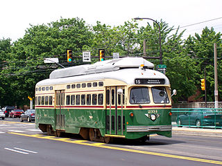
Route 15, the Girard Avenue Line, is a trolley line operated by the Southeastern Pennsylvania Transportation Authority (SEPTA) along Girard Avenue through North and West Philadelphia, Pennsylvania, United States. As of 2007, it is the only surface trolley line in the City Transit Division that is not part of the Subway–Surface Trolley Lines. SEPTA PCC II vehicles are used on the line.

Cecil B. Moore is a neighborhood in the North Philadelphia section of the city of Philadelphia, Pennsylvania, United States, named after the late Philadelphia-based civil rights attorney and politician Cecil B. Moore. The district is loosely arranged around the main campus of Temple University. The neighborhood has gentrified due to an influx of Temple students during the past several years. The controversial term "Templetown" was coined by former Temple president Peter J. Liacouras, but has only recently come into wide use after a real estate development company adopted the name. Cecil B. Moore Avenue is the street running parallel to Oxford and Montgomery, intersecting with N. Broad Street in the neighborhood.
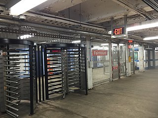
Fairmount station is a subway station in the Francisville section of North Philadelphia, Pennsylvania. It is served by SEPTA's Broad Street Line and the Broad-Ridge Spur. There are three separate platforms. The Broad-Ridge Spur and Broad Street Line (BSL) northbound platforms connect inside the faregates, but the BSL's southbound platform cannot be reached from the other two without exiting. Such a connection once existed; the sealed-off entrance can be seen at platform level heading south towards the end of the platform. Travelers wishing to switch between the Broad-Ridge Spur and the southbound BSL must connect at Girard. The Broad-Ridge Spur platform is shortened and can only accommodate short 2-car trains; the unused part of the platform is visible from passing trains and is covered in layers of graffiti. Fairmount station on the Broad-Ridge Spur has a full mezzanine concourse extending from Wallace Street to Ridge Avenue, now abandoned.

Point Breeze is a multicultural neighborhood in South Philadelphia in Philadelphia, Pennsylvania, United States. It is bounded by 25th Street to the west, Washington Avenue to the north, 18th Street to the east, and Moore Street to the south. Southwest Center City lies to its north. Passyunk Square and East Passyunk Crossing lie to its east. Point Breeze is separated from Grays Ferry to the west by a CSX railway viaduct over 25th Street.
Sharswood is a small neighborhood in the North Philadelphia section of the city of Philadelphia, Pennsylvania in the United States. It is located to the east of Brewerytown, north of Girard College, west of Ridge Avenue, east of 24th Street and south of Cecil B. Moore Avenue. It is often grouped with Brewerytown, as in the Brewerytown-Sharswood Community Civic Association, and the Brewerytown-Sharswood NTI Planning Area.

Spring Garden is a neighborhood in central Philadelphia, Pennsylvania, bordering Center City on the north. Spring Garden is a neighborhood that combines diverse residential neighborhoods and significant cultural attractions.

U.S. Route 13 (US 13) is a United States Numbered Highway running from Fayetteville, North Carolina, north to Morrisville, Pennsylvania. The route runs for 49.359 miles (79.436 km) through the Delaware Valley in the U.S. state of Pennsylvania. The route enters the state from Delaware in Marcus Hook, Delaware County. It continues northeast through Delaware County, passing through the city of Chester before heading through suburban areas along Chester Pike to Darby. US 13 enters the city of Philadelphia on Baltimore Avenue and runs through West Philadelphia to University City, where it turns north along several city streets before heading east across the Schuylkill River along Girard Avenue. The route turns north and heads to North Philadelphia, where it runs northeast along Hunting Park Avenue. US 13 becomes concurrent with US 1 on Roosevelt Boulevard, continuing into Northeast Philadelphia. US 13 splits southeast on a one-way pair of streets before heading northeast out of the city on Frankford Avenue. The route continues into Bucks County as Bristol Pike, heading northeast to Bristol, where it turns into a divided highway. US 13 becomes a freeway in Tullytown and continues north to its terminus at US 1 in Falls Township, near Morrisville. US 13 roughly parallels Interstate 95 (I-95) through its course in Pennsylvania.
SEPTA Route 38 is a bus and former streetcar route operated by the Southeastern Pennsylvania Transportation Authority (SEPTA) in Philadelphia, Pennsylvania, United States.

Girard station is a subway station on the SEPTA Broad Street Line in the Francisville section of North Philadelphia, Pennsylvania. It is an express station, with four tracks and two central platforms. This is the last station where southbound riders can transfer freely between the Ridge Spur line and the Main Line, and the two trains commonly meet here and wait for one another. Girard station is located in a very busy commercial strip along Girard Avenue, and also serves the southernmost sections of Temple University. A transfer is available to the Route 15 trolley, which provides local service along Girard Avenue.

Wissahickon is a neighborhood in the section of Lower Northwest Philadelphia in the state of Pennsylvania, United States. Wissahickon is located adjacent to the neighborhoods of Roxborough and Manayunk, and it is bounded by the Wissahickon Valley Park, Ridge Avenue, Hermit Street, and Henry Avenue. The name of the neighborhood is derived from the Lenni Lenape word wisameckham, for "catfish creek", a reference to the fish that were once plentiful in the Wissahickon Creek.

Poplar is a neighborhood in Lower North Philadelphia, Pennsylvania, United States. It is located north of Callowhill, between Spring Garden/Fairmount and Northern Liberties, bounded roughly by Girard Avenue to the north, North Broad Street to the west, Spring Garden Street to the south, and 5th Street to the east. The neighborhood is predominantly residential, with commercial frontage on Broad Street and Girard Avenue and some industrial facilities to the west of the railroad tracks along Percy St. and 9th St.

Girard Avenue is a major commercial and residential street in Philadelphia. For most of its length it runs east–west, but at Frankford Avenue it makes a 135-degree turn north. Parts of the road are signed as U.S. Route 13 and U.S. Route 30.
North Philadelphia West is a neighborhood that is located in the western central part of the North Philadelphia section of Philadelphia, Pennsylvania, United States, east of the Schuylkill River.
Ridge Pike is a major historic road in the U.S. state of Pennsylvania that opened in 1706 that originally connected Wissahickon Creek to Perkiomen Creek. Inside Philadelphia, it is called Ridge Avenue. Going westward, it traverses many eastern Pennsylvania neighborhoods in Montgomery County including Conshohocken and beyond, connecting with Germantown Pike near Collegeville and continuing to Pottstown. In Montgomery County, Ridge Pike is called Main Street in the Norristown area and again in Collegeville and Trappe, and is called High Street in the Pottstown area.

