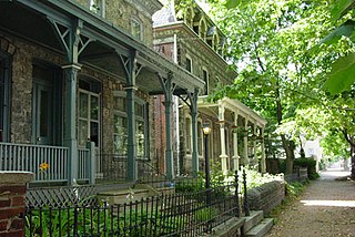
Powelton Village is a neighborhood of mostly Victorian, mostly twin homes in the West Philadelphia section of the United States city of Philadelphia, Pennsylvania. It is a national historic district that is part of University City. It extends north from Market Street to Spring Garden Street, east to 32nd Street, west to 40th and Spring Garden Streets, and to 44th and Market Streets.

Fishtown is a neighborhood in the River Wards section of Philadelphia, Pennsylvania, United States. Located northeast of Center City Philadelphia, its borders are somewhat disputed today due to many factors, but are roughly defined by the triangle created by the Delaware River, Frankford Avenue, and York Street. Some newer residents expand the area to Lehigh Avenue, while some older residents shrink the area to Norris Street. It is served by the Market–Frankford Line rapid transit subway/elevated line of the SEPTA system. Fishtown is a largely working class Irish Catholic neighborhood, but has recently seen a large influx of young urban professionals and gentrification.
Northeast Philadelphia, nicknamed Northeast Philly, the Northeast and the Great Northeast, is a section of Philadelphia, Pennsylvania. According to the 2000 census, Northeast Philadelphia has a population of between 300,000 and 450,000, depending on how the area is defined. Beginning in the 1980s, many of the Northeast's middle class children graduated from college and settled in suburbs, especially nearby Bucks County. The Northeast is known as being home to a large working class Irish American population, but it is also home to Polish, German, Jewish, Italian, African American, Portuguese, Brazilian, Russian, Puerto Rican, Dominican, Ukrainian, Indian, Chinese, and Vietnamese neighborhoods.
Frankford is a neighborhood in the Northeast section of Philadelphia situated about six miles (10 km) northeast of Center City. Although its borders are vaguely defined, the neighborhood is bounded roughly by the original course of Frankford Creek on the south to Oakland Street on the northwest and southwest, to Bridge Street on the north, and to Aramingo Avenue and I-95 on the east. Adjacent neighborhoods are Bridesburg, Juniata, Northwood, Summerdale, and Wissinoming.
Lawncrest is a neighborhood in the "Near" (lower) Northeast Philadelphia, Pennsylvania. The name is an amalgam of Lawndale and Crescentville, the two primary communities that make up the neighborhood. The Philadelphia Inquirer does not consider Lawncrest to be a neighborhood.
Holmesburg began as a Village within Lower Dublin Township, Pennsylvania. It is now a neighborhood in the Northeast section of Philadelphia, Pennsylvania. Holmesburg was named in Honor of Surveyor General of Pennsylvania Thomas Holme, who was a cartographer.

Kensington, colloquially known locally as “Kenzo,” is a neighborhood in Philadelphia that belongs to or divides Lower Northeast and North Philadelphia. As with all neighborhoods in the city, the lack of any official designation means the boundaries of the area vary between sources over time and are disputed among locals. Kensington, as most long-term residents view it, refers generally to the area consisting of Kensington, East, or Lower Kensington, West Kensington, and Harrowgate. The adjacent Fairhill and Norris Square neighborhoods are more separate but may be included in Kensington; Fishtown and South (Olde) Kensington were previously included but have developed new identities with gentrification. The most conservative boundaries of the neighborhood, shown in the map below, are Front Street and 5th Street to the west, the Amtrak train tracks to the North, Trenton Avenue, the Trenton Avenue train tracks, and Frankford Avenue to the east, and Cecil B. Moore Avenue to the south.

Mayfair is a working class neighborhood in lower Northeast Philadelphia, centered on the intersection of Cottman and Frankford Avenues. It is bordered by Tacony and Wissinoming to the south and east, Holmesburg to the east, Pennypack Park to the north, and Oxford Circle and Rhawnhurst to the west. Mayfair is historically home to a large Irish American population, but more recently has seen accelerated growth of Asian American population

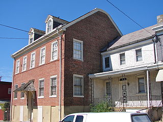
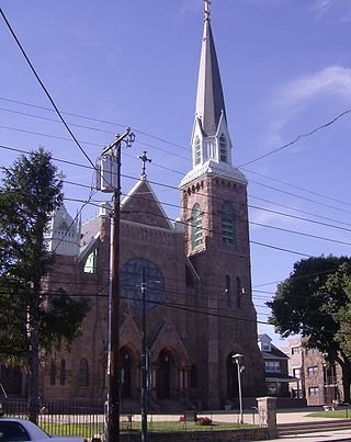
Bridesburg is the northernmost neighborhood in the River Wards section of Philadelphia, Pennsylvania, United States. Bridesburg is an historically German and Irish community, with a significant community of Polish immigrants who arrived mostly in the early- to mid-twentieth century. The community is home to two Catholic churches: All Saints Church, designed by Edwin Forrest Durang, built in 1889; and Saint John Cantius Church, built in 1898 in Polish Cathedral style.

Juniata is a working class, predominantly Hispanic and Caucasian neighborhood in Northeast Philadelphia, which is a section of the city of Philadelphia, Pennsylvania, United States. Juniata is located south of the Juniata Golf Club in Tacony Creek Park. It is bordered to the east by Frankford, to the west by Feltonville, and to the south by Harrowgate and Port Richmond. The neighborhood is bordered by G Street to the west, Juniata Park to the north, Tacony Creek to the east, and by SEPTA rail tracks to the south. Juniata shares the ZIP code of 19124 with the nearby neighborhood of Frankford.

Spring Garden station is a SEPTA rapid transit station in Philadelphia, Pennsylvania, United States, on the Market–Frankford Line. It is located on Spring Garden Street between 2nd and Front Streets in the Northern Liberties neighborhood. It is the westernmost station of the Frankford Elevated section of the line and the last westbound station before trains enter Center City Philadelphia.
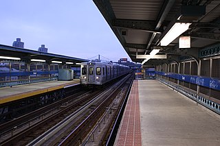
Girard station is an elevated rapid transit station which is located in Philadelphia, Pennsylvania, on SEPTA's Market–Frankford Line. It is situated at the corner of Front Street and Girard Avenue in the Fishtown neighborhood.
Wissinoming is a neighborhood in the Near Northeast section of Philadelphia. It was the site of locomotive builder Matthias Baldwin's estate "Wissinoming", which was located near Tacony and Van Kirk Streets. The current Wissinoming is bordered by Mayfair on the west and Tacony on the north, Bridesburg on the south, I-95 and the Delaware River on the east, and Frankford on the southwest. Wissinoming has two ZIP codes: 19124 and 19135. Physical boundaries are: Levick Street on the north, Bridge Street on the south, I-95 and the Delaware River on the east, and Frankford Avenue on the west.
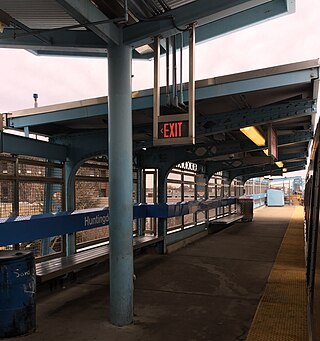
Huntingdon station is a SEPTA elevated rapid transit station in Philadelphia, Pennsylvania, serving the Market–Frankford Line. It is located at the intersection of Kensington Avenue, Huntingdon Street, and B Street in the Kensington neighborhood of the city. It is the westernmost station on the line located above Kensington Avenue and is also served by SEPTA bus routes 3, 39, and 54.

Allegheny station is a rapid transit station on SEPTA Market–Frankford Line in Philadelphia, Pennsylvania. It is located at the intersection of Kensington and Allegheny avenues and H Street in the Kensington neighborhood of North Philadelphia. The station is also served by SEPTA City Bus routes 3, 60, and 89.

Erie–Torresdale station is an elevated rapid transit station in Philadelphia, Pennsylvania, served by the SEPTA Market–Frankford Line. It is located at the intersection of Kensington, Erie, and Torresdale avenues in the Juniata neighborhood of Northeast Philadelphia. The station is also served by SEPTA City Bus routes 3 and 56, both of which are former trolley lines.
Arrott Transportation Center is an elevated rapid transit station and bus station serving SEPTA's Market–Frankford Line and City Bus routes. It is located at the intersection of Frankford Avenue, Oxford Avenue, Arrott Street, Paul Street, and Margaret Street in the Frankford neighborhood of Northeast Philadelphia, Pennsylvania. The terminal was originally known by two separate names, Margaret–Orthodox station for the Market–Frankford Line and Arrott Bus Terminal for bus routes.

SEPTA Route 66 is a trackless trolley route in Northeast Philadelphia, Pennsylvania, United States. It connects the Market–Frankford Line at the Frankford Transportation Center to Wissinoming, Mayfair, Holmesburg, and Torresdale along Frankford Avenue, which is US 13 and includes the historic, colonial Frankford Avenue Bridge.

Girard Avenue is a major commercial and residential street in Philadelphia, Pennsylvania. For most of its length it runs east–west, but at Frankford Avenue it makes a 135-degree turn north. Parts of the road are signed as U.S. Route 13 and U.S. Route 30.
Olde Richmond is a neighborhood in the River Wards section of Philadelphia, Pennsylvania, United Sttes. It is notable for its historically large Polish immigrant, Polish American community, and Irish American community. The U.S. ZIP Code for Olde Richmond is 19125 and its post office is located at 1602 Frankford Avenue.
