
Capon Chapel, also historically known as Capon Baptist Chapel and Capon Chapel Church, is a mid-19th century United Methodist church located near to the town of Capon Bridge, West Virginia, in the United States. Capon Chapel is one of the oldest existing log churches in Hampshire County, along with Mount Bethel Church and Old Pine Church.

The history of Indianapolis spans three centuries. Founded in 1820, the area where the city now stands was originally home to the Lenape. In 1821, a small settlement on the west fork of the White River at the mouth of Fall Creek became the county seat of Marion County, and the state capital of Indiana, effective January 1, 1825. Initially the availability of federal lands for purchase in central Indiana made it attractive to the new settlement; the first European Americans to permanently settle in the area arrived around 1819 or early 1820. In its early years, most of the new arrivals to Indianapolis were Europeans and Americans with European ancestry, but later the city attracted other ethnic groups. The city's growth was encouraged by its geographic location, 2 miles (3.2 km) northwest of the state's geographic center. In addition to its designation as a seat of government, Indianapolis's flat, fertile soil, and central location within Indiana and the Midwest, helped it become an early agricultural center. Its proximity to the White River, which provided power for the town's early mills in the 1820s and 1830s, and the arrival of the railroads, beginning in 1847, established Indianapolis as a manufacturing hub and a transportation center for freight and passenger service. An expanding network of roads, beginning with the early National Road and the Michigan Road, among other routes, connected Indianapolis to other major cities.
Lyles or Lyles Station is an unincorporated community in Patoka Township, Gibson County, Indiana. The community dates from 1849, although its early settlers first arrived in the 1830s, and it was formally named Lyles Station in 1886 to honor Joshua Lyles, a free African American who migrated with his family from Tennessee to Indiana around 1837. Lyles Station is one of Indiana's early black rural settlements and the only one remaining. The rural settlement reached its peak in the years between 1880 and 1912, when major structures in the community included the railroad depot, a post office, a lumber mill, two general stores, two churches, and a school. By the turn of the twentieth century, Lyles Station had fifty-five homes, with a population of more than 800 people. The farming community never fully recovered from the Great Flood of 1913, which destroyed much of the town. Most of its residents left for economic reasons, seeking opportunities for higher paying jobs and additional education in larger cities. By 1997 approximately fifteen families remained at Lyles Station, nearly all of them descended from the original settlers.

Monroe Township is one of thirteen townships in Putnam County, Indiana. As of the 2010 census, its population was 1,569 and it contained 672 housing units.

Polk Township is one of eleven townships in Monroe County, Indiana. As of the 2010 census, its population was 360 and it contained 195 housing units. It is one of the least densely-populated townships in the state; this is largely because most of the land is occupied by Lake Monroe, the Hoosier National Forest, and seasonal homes and attractions.

Oregon Township is one of twelve townships in Clark County, Indiana. As of the 2010 census, its population was 1,769 and it contained 692 housing units.

Wood Township is one of twelve townships in Clark County, Indiana. As of the 2010 census, its population was 2,747 and it contained 1,148 housing units.

Madison Township is one of ten townships in Jefferson County, Indiana, United States. As of the 2010 census, its population was 17,415 and it contained 8,087 housing units.

Milton Township is one of ten townships in Jefferson County, Indiana, United States. As of the 2010 census, its population was 896 and it contained 470 housing units.

Monroe Township is one of ten townships in Jefferson County, Indiana, United States. As of the 2010 census, its population was 374 and it contained 176 housing units.
Lancaster is an unincorporated community in Lancaster Township, Jefferson County, Indiana.

Tunnelton is an unincorporated community in Guthrie Township, Lawrence County, Indiana.

Sanders is an unincorporated community in Perry Township, Monroe County, in the U.S. state of Indiana.

Bohlen, Meyer, Gibson and Associates, or BMG, is an architectural firm based in Indianapolis, Indiana. It was founded in Indianapolis on April 10, 1853, as D. A. Bohlen, Architect by Diedrich A. Bohlen, German immigrant. In 1884, after Diedrich's son, Oscar D. Bohlen, joined the firm it was renamed D. A. Bohlen and Son. Four successive generations of Bohlen architects have worked at the firm: Diedrich A. Bohlen, Oscar D. Bohlen, August C. Bohlen, and Robert L. Bohlen. The firm specialized in institutional projects, especially civic, religious, and educational buildings. In 1971 Melvin B. G. Meyer acquired majority interest in the firm, which adopted its name in reference to its founder and its two principal architects, Meyer and John M. Gibson. The architectural firm is among the oldest still operating in the United States. More than twenty of its projects are listed on the National Register of Historic Places.

Roberts Chapel, is a non-denominational church that was originally built in 1847 at Roberts Settlement, one of Indiana's early black pioneer communities. The rural church, whose main building dates from 1858, is located near the present-day town of Atlanta in rural Jackson Township, Hamilton County, Indiana. The chapel was listed on the National Register of Historic Places in 1996.
Maryland Ridge in Indiana was an unincorporated community of settlers from Calvert County, Maryland, in the early 19th century. The settlers came to Indiana after the War of 1812 in successive waves between 1818 and 1839. One community where they settled became known as Maryland Ridge. The geographic area follows the ridges and streams of Indian Creek along the Monroe-Greene County line.
Weaver is an unincorporated community in Liberty Township, Grant County, Indiana. Weaver's first settlers were free people of color who migrated from North Carolina and South Carolina to Grant County in the early 1840s. The neighborhood was originally known as Crossroad; however, it was later renamed Weaver in honor of a prominent family of the community. The rural settlement reached its peak in the late 1800s, when its population reportedly reached 2,000. Many of its residents left the community for higher-paying jobs in larger towns during the Indiana's natural gas boom, but more than 100 families remained in the settlement in the early 1920s. Weaver, as with most of Indiana's black rural settlements, no longer exists as a self-contained community, but Weaver Cemetery remains as a community landmark.
Brick Chapel is an unincorporated community in Monroe Township, Putnam County, in the U.S. state of Indiana.

Roberts Park Methodist Episcopal Church, whose present-day name is Roberts Park United Methodist Church, was dedicated on August 27, 1876, making it one of the oldest church remaining in downtown Indianapolis. Diedrich A. Bohlen, a German-born architect who immigrated to Indianapolis in the 1850s, designed this early example of Romanesque Revival architecture. The church is considered one of Bohlen's major works. Constructed of Indiana limestone at Delaware and Vermont Streets, it has a rectangular plan and includes a bell tower on the southwest corner. The church is known for its interior woodwork, especially a pair of black-walnut staircases leading to galleries (balconies) surrounding the interior of three sides of its large sanctuary. The church was added to the National Register of Historic Places on August 19, 1982. It is home to one of several Homeless Jesus statues around the world, this one located behind the church on Alabama Street.
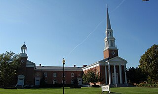
Meridian Street United Methodist Church, known in its early years as Wesley Chapel, the Meridian Street Methodist Episcopal Church, and the Meridian Street Methodist Church, is a Methodist church located at 5500 North Meridian Street in Indianapolis, Indiana. The church originated from the first Methodist congregation in Indianapolis that began in a log cabin in 1821–22 with fifty members. The congregation worshipped at several locations and erected four earlier churches on Monument Circle and along Meridian Street in downtown Indianapolis before it merged with the Fifty-first Street Methodists in 1945. The first service at its North Meridian Street location was held on June 29, 1952. Designed by the architectural firm of Russ and Harrison, the Georgian-Colonial-style, red-brick church is noted for its architecture, pipe organ, and formal parlor. The Aldersgate addition on the west side (rear) of the church was consecrated on October 4, 1989.


