Ellettsville, Indiana

Last updated

Ellettsville, Indiana
Downtown Ellettsville.jpg
Downtown Ellettsville
Motto: 
"Builders Of American History"
Monroe County Indiana Incorporated and Unincorporated areas Ellettsville Highlighted 1820800.svg
Location of Ellettsville in Monroe County, Indiana.
Coordinates: 39°13′56″N86°37′27″W / 39.23222°N 86.62417°W / 39.23222; -86.62417
Country United States
State Indiana
County Monroe
Township Richland
Area
[1]
  Total5.17 sq mi (13.40 km2)
  Land5.17 sq mi (13.40 km2)
  Water0.00 sq mi (0.00 km2)
Elevation
[2]
696 ft (212 m)
Population
 (2020)
  Total6,655
  Density1,286.24/sq mi (496.61/km2)
Time zone UTC-5 (Eastern (EST))
  Summer (DST) UTC-5 (EST)
ZIP code
47429
Area code(s) 812, 930
FIPS code 18-20800 [3]
GNIS feature ID2396926 [2]
Website http://www.ellettsville.in.us

Ellettsville is a town in Richland Township, Monroe County, Indiana, United States. [2] The population was 6,655 at the 2020 census. It is part of the Bloomington, Indiana Metropolitan Statistical Area.

Contents

History

Ellettsville was platted in 1837. [4] In 1818, Edward Ellett, Sr, and his wife Eleanor settled in what is now known as Ellettsville with their four minor sons: David, Richard, Johnston and Barton. The first winter, they lived in a three-sided log cabin they built. [5] Also settling that year were their two eldest sons, William and Samuel, with their wives and families. [6] Within a few years daughters Sarah, Phoebe and Nancy settled in the area with their husbands. In 1826, their third eldest son, Edward, Jr., also arrived in the town that was named Ellettsville in 1837. [7] Samuel Ellett built the first courthouse in 1820. It was completed ahead of schedule and at the cost of $400. By 1822, the first school opened and with Samuel Ellett's children attending. [8]

When Indiana celebrated its sesquicentennial in 1987, a historical marker was placed to mark the grave of the town's founder, Edward Ellett, Sr. (c.1762-1833). [8] Two of Edward Ellett's sons, Samuel and Edward Jr., fought in The War of 1812. [9] In turn, three of the founder's grandsons fought to preserve the Union in the Civil War. Stephen R. Ellett fought with the 67th Indiana Infantry Regiment, at the Battle of Vicksburg, while his younger brothers, James W. Ellett and John H. Ellett, volunteered and fought with the 27th Indiana Volunteer Infantry Regiment [10] [11] at Gettysburg. James Ellett died in service of his county in 1864 in Alabama while his brother, John Ellett, was wounded at Chancellorsville but survived the Civil War. [11] [12] The family tradition of loyal service to the U.S. was later followed by the founder's great great grandson, Dale Ellett, who volunteered and died in World War II in 1945 fighting against Nazi Germany. [13]

The post office at Ellettsville has been in operation since 1837. [14] The community was incorporated as a town in 1866. [15]

Ellettsville Downtown Historic District was listed on the National Register of Historic Places in 2006. [16]

Photo from Small Town Indiana photo survey. Ellettsville, Indiana building.jpg
Photo from Small Town Indiana photo survey.

Geography

According to the 2010 census, Ellettsville has a total area of 4.24 square miles (10.98 km2), all land. [17]

Photo from Small Town Indiana photo survey. Ellettsville, Indiana.jpg
Photo from Small Town Indiana photo survey.

Demographics

Historical population
CensusPop.Note
1850 74
1880 585
1890 71221.7%
1900 708−0.6%
1910 676−4.5%
1920 7216.7%
1930 7676.4%
1940 86312.5%
1950 855−0.9%
1960 1,22242.9%
1970 1,62733.1%
1980 3,328104.5%
1990 3,275−1.6%
2000 5,07855.1%
2010 6,37825.6%
2020 6,6554.3%
U.S. Decennial Census [18]


2010 census

At the 2010 census, [19] there were 6,378 people, 2,593 households and 1,704 families living in the town. The population density was 1,504.2 per square mile (580.8/km2). There were 2,753 housing units at an average density of 649.3 per square mile (250.7/km2). The racial makeup was 95.5% White, 1.0% African American, 0.2% Native American, 0.6% Asian, 0.7% from other races, and 1.9% from two or more races. Hispanic or Latino of any race were 1.6% of the population.

There were 2,593 households, of which 35.3% had children under the age of 18 living with them, 47.2% were married couples living together, 13.6% had a female householder with no husband present, 5.0% had a male householder with no wife present, and 34.3% were non-families. 28.2% of all households were made up of individuals, and 9.7% had someone living alone who was 65 years of age or older. The average household size was 2.43 and the average family size was 2.98.

The median age was 34.5 years. 26.5% of residents were under the age of 18; 7.7% were between the ages of 18 and 24; 30.7% were from 25 to 44; 23% were from 45 to 64; and 12.1% were 65 years of age or older. The gender makeup of the town was 46.7% male and 53.3% female.

2000 census

At the 2000 census, [3] there were 5,078 people, 1,944 households and 1,345 families living in the town. The population density was 2,356.8 per square mile (910.0/km2). There were 2,085 housing units at an average density of 967.7 per square mile (373.6/km2). The racial make-up was 95.83% White, 1.22% African American, 0.18% Native American, 0.73% Asian, 0.81% from other races, and 1.24% from two or more races. Hispanic or Latino of any race were 1.18% of the population.

There were 1,944 households, of which 40.8% had children under the age of 18 living with them, 51.2% were married couples living together, 13.2% had a female householder with no husband present, and 30.8% were non-families. 25.4% of all households were made up of individuals, and 9.1% had someone living alone who was 65 years of age or older. The average household size was 2.57 people, and the average family size was 3.09 people.

30.1% of the population were under the age of 18, 8.4% from 18 to 24, 32.7% from 25 to 44, 19.4% from 45 to 64, and 9.4% who were 65 years of age or older. The median age was 33 years. For every 100 females, there were 90.7 males. For every 100 females age 18 and over, there were 83.0 males.

The median household income was $37,276 and the median family income was $42,950. Males had a median income of $32,153 and females $26,313. The per capita income was $16,120. About 6.7% of families and 9.2% of the population were below the poverty line, including 9.8% of those under age 18 and 12.6% of those age 65 or over.

Education

Edgewood High School serves students in grades 9-12. Edgewood Junior High School serves grades 6-8. Edgewood Intermediate School serves grades 3-5. Edgewood Primary School serves grades K-2. Richland-Bean Blossom Community School Corporation represents the two townships (Richland and Bean Blossom) in northwestern Monroe County.

Ellettsville has a public library, a branch of the Monroe County Public Library. [20]

Related Research Articles

<span class="mw-page-title-main">Butler County, Ohio</span> County in Ohio, United States

Butler County is a county located in the southwestern part of the U.S. state of Ohio. As of the 2020 census, the population was 390,357. Its county seat and largest city is Hamilton. It is named for General Richard Butler, who died in 1791 during St. Clair's Defeat. Located along the Great Miami River, it is also home to Miami University, a public university founded in 1809. Butler County is part of the Cincinnati, OH-KY-IN Metropolitan Statistical Area. The majority of the county is in District 52 of the State House.

<span class="mw-page-title-main">Monroe County, Indiana</span> County in Indiana, United States

Monroe County is a county in the U.S. state of Indiana. In 1910 the US Census Bureau calculated the nation's mean population center to lie in Monroe County. The population was 139,718 at the 2020 United States Census. The county seat is Bloomington. Monroe County is part of the Bloomington, Indiana, Metropolitan Statistical Area.

<span class="mw-page-title-main">Richland, Georgia</span> City in Georgia, United States

Richland is a city in Stewart County, Georgia, United States. Per the 2020 census, the population was 1,370.

<span class="mw-page-title-main">Hecker, Illinois</span> Village in Illinois, United States

Hecker is a village in Monroe County in the U.S state of Illinois. The population was 429 at the 2020 census, down from 481 in 2010.

<span class="mw-page-title-main">Monroe, Adams County, Indiana</span> Town in Indiana, United States

Monroe is a town in Washington and Monroe townships, Adams County, Indiana, United States. The population of the town was 945 residents at the 2019 census. Adams Central Community Schools is located in Monroe.

<span class="mw-page-title-main">Thorntown, Indiana</span> Town in Indiana, United States

Thorntown is a town in Sugar Creek Township, Boone County, Indiana. The population was 1,520 at the time of the 2010 census. Thorntown is located in northwestern Boone County, about halfway between Lafayette and Indianapolis.

<span class="mw-page-title-main">Flora, Indiana</span> Town in Indiana, United States

Flora is a town in Monroe Township, Carroll County, Indiana, United States. The population was 2,036 at the 2010 census. It is part of the Lafayette, Indiana Metropolitan Statistical Area.

<span class="mw-page-title-main">Matthews, Indiana</span> Town in Indiana, United States

Matthews is a town in Jefferson Township, Grant County, Indiana, United States, along the Mississinewa River. The population was 596 at the 2010 census.

<span class="mw-page-title-main">Edgewood, Indiana</span> Town in Indiana, United States

Edgewood is a town in Anderson Township, Madison County, Indiana, United States. It is part of the Indianapolis–Carmel–Anderson metropolitan statistical area. The population was 2,053 at the 2020 census.

<span class="mw-page-title-main">River Forest, Indiana</span> Town in Indiana, United States

River Forest is a town in Anderson Township, Madison County, Indiana, United States. It is part of the Indianapolis–Carmel–Anderson metropolitan statistical area. The population was 26 at the 2020 census.

<span class="mw-page-title-main">Bloomington, Indiana</span> City in Indiana, United States

Bloomington is a city in and the county seat of Monroe County, Indiana, United States. The population was 79,168 at the 2020 census. It is the seventh-largest city in Indiana and the fourth-largest outside the Indianapolis metropolitan area. It is the home of Indiana University Bloomington, the flagship campus of the IU System. Established in 1820, IU Bloomington enrolls over 45,000 students.

<span class="mw-page-title-main">Stinesville, Indiana</span> Town in Indiana, United States

Stinesville is a town in Bean Blossom Township, Monroe County, in the U.S. state of Indiana. The population was 203 at the 2020 census. It is part of the Bloomington Metropolitan Statistical Area.

<span class="mw-page-title-main">Edgewood, Iowa</span> City in Iowa, United States

Edgewood is a city in Clayton and Delaware counties in the U.S. state of Iowa. Highway 3, which runs through the center of town, is the dividing line between the two counties. The Edgewood post office was established in 1852 on the Clayton side of the town. Edgewood was formally incorporated in 1892, although it had a functioning council for some time before that date. The population was 909 at the time of the 2020 census, down from 923 in 2000.

<span class="mw-page-title-main">Richland, Michigan</span> Village in Michigan, United States

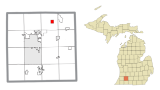
Richland is a village in Kalamazoo County in the U.S. state of Michigan. The population was 751 at the 2010 census, up from 593 at the 2000 census.

<span class="mw-page-title-main">Edgewood, New Mexico</span> Town in New Mexico, United States

Edgewood is a town in Santa Fe County, New Mexico, United States. Through annexations, its town boundaries now extend into Bernalillo and Sandoval counties. It is part of the Albuquerque–Santa Fe–Las Vegas combined statistical area.

<span class="mw-page-title-main">Richlands, North Carolina</span> Town in North Carolina, United States

Richlands is a town in Onslow County, North Carolina, United States. In the 2020 U.S. census, the population was 2,287. It is included in the Jacksonville, North Carolina Metropolitan Statistical Area. Incorporated on March 29, 1880, it was the first town in Onslow County to have its own library and museum. Richlands was also the first town in Onslow County to have a female mayor, Annette Hargett.

<span class="mw-page-title-main">Lucas, Ohio</span> Village in Ohio, United States

Lucas is a village in southeastern Richland County, Ohio, United States. Lucas is part of the Mansfield, Ohio Metropolitan Statistical Area. The population was 589 at the 2020 census.

<span class="mw-page-title-main">Plumville, Pennsylvania</span> Borough in Pennsylvania, United States

Plumville is a borough in Indiana County, Pennsylvania, United States. The population was 257 at the 2020 census.

<span class="mw-page-title-main">Bloomington metropolitan area, Indiana</span>

The Bloomington, Indiana, Metropolitan Statistical Area, as defined by the United States Census Bureau, is an area comprising three counties in south-central Indiana. The city of Bloomington in Monroe County is the area's principal municipality and its anchor. At the 2010 United States census, the MSA had a population of 192,714.

Ronald Ellett is a retired American football coach.

References

  1. "2020 U.S. Gazetteer Files". United States Census Bureau. Retrieved March 16, 2022.
  2. 1 2 3 U.S. Geological Survey Geographic Names Information System: Ellettsville, Indiana
  3. 1 2 "U.S. Census website". United States Census Bureau . Retrieved January 31, 2008.
  4. History of Lawrence and Monroe Counties, Indiana: Their People, Industries, and Institutions. B.F. Bowen. 1914. pp.  435.
    - "New Ellettsville/Richland Group Draws Small Crowd of Citizens", Ellettsville Journal, December 8, 2010, 1.
  5. Carter, Lang, and Matthews (1988). Leaves from the Ellett-Elliott Family Tree. pp. 4–6.{{cite book}}: CS1 maint: multiple names: authors list (link)
  6. Carter, Lang, and Matthews (1988). Leaves from the Ellett-Elliott Family Tree. pp. 12–46.{{cite book}}: CS1 maint: multiple names: authors list (link)
  7. Carter, Lang, and Matthews (1988). Leaves from the Ellett-Elliott Family Tree. pp. 52–85.{{cite book}}: CS1 maint: multiple names: authors list (link)
  8. 1 2 Carter, Lang, and Matthews (1988). Leaves from the Ellett-Elliott Family Tree. p. 5.{{cite book}}: CS1 maint: multiple names: authors list (link)
  9. Carter, Lang, and Matthews (1988). Leaves from the Ellett-Elliott Family Tree. p. 2.{{cite book}}: CS1 maint: multiple names: authors list (link)
  10. Brown, E.R. (1899). The Twenty-Seventh Indiana Volunteer Infantry in the War of Rebellion, 1861 TO 1865. p. 584.
  11. 1 2 Carter, Lang, and Matthews (1988). Leaves from the Ellett-Elliott Family Tree. p. 104.{{cite book}}: CS1 maint: multiple names: authors list (link)
  12. Brown, E.R. (1899). The Twenty-Seventh Indiana Volunteer Infantry in the War of Rebellion, 1861 TO 1865. p. 584.
  13. Carter, Lang, and Matthews (1988). Leaves from the Ellett-Elliott Family Tree. p. 105.{{cite book}}: CS1 maint: multiple names: authors list (link)
  14. "Monroe County". Jim Forte Postal History. Retrieved June 18, 2017.
  15. Blanchard, Charles (1884). Counties of Morgan, Monroe and Brown, Indiana: Historical and Biographical. F.A. Battey & Company. pp.  505.
  16. "National Register Information System". National Register of Historic Places . National Park Service. July 9, 2010.
  17. "G001 - Geographic Identifiers - 2010 Census Summary File 1". United States Census Bureau. Archived from the original on February 13, 2020. Retrieved July 16, 2015.
  18. "Census of Population and Housing". Census.gov. Retrieved June 4, 2015.
  19. "U.S. Census website". United States Census Bureau . Retrieved December 11, 2012.
  20. "Hours & Locations". Monroe County Public Library. January 23, 2012. Retrieved March 10, 2018.