
Grenada is an island country located between the Caribbean Sea and Atlantic Ocean, north of Trinidad and Tobago. It is located at 12°07′N61°40′W. There are no large inland bodies of water on the island, which consists entirely of the state of Grenada. The coastline is 121 km long. The island has 15 constituencies and speaks English and Grenadian Creole. It is volcanic in origin and its topography is mountainous.

The economy of Grenada is largely tourism-based, small, and open economy. Over the past two decades, the main thrust of Grenada's economy has shifted from agriculture to services, with tourism serving as the leading foreign currency earning sector. The country's principal export crops are the spices nutmeg and mace. Other crops for export include cocoa, citrus fruits, bananas, cloves, and cinnamon. Manufacturing industries in Grenada operate mostly on a small scale, including production of beverages and other foodstuffs, textiles, and the assembly of electronic components for export.

Barbados is a continental island in the North Atlantic Ocean and is located at 13°10' north of the equator, and 59°32' west of the Prime Meridian. As the easternmost isle of the Lesser Antilles in the West Indies, Barbados lies 160 kilometres (100 mi) east of the Windward Islands and Caribbean Sea. The maritime claim for Barbados is a territorial sea of 12 nmi, with an exclusive economic zone of 200 nmi which gives Barbados a total maritime area of 186,898 km2 (72,162 sq mi). Of the total EEZ area, 70,000 km2 is set aside for offshore oil exploration. A pending application to UNCLOS has placed for consideration a continental shelf 200 nmi to the east and south. To the west, most of Barbados' maritime boundaries consist of median lines with neighbours. These neighbours include: Martinique, and Saint Lucia to the northwest, Saint Vincent and the Grenadines to the west, Trinidad and Tobago and Venezuela to the southwest, and Guyana to the southeast.

Carriacou and Petite Martinique, also known as the Southern Grenadines, is a dependency (part) of Grenada, lying north of Grenada island and south of Saint Vincent and the Grenadines in the Lesser Antilles.

The Governor-General of Grenada is the representative of the Grenadian monarch, currently King Charles III, in Grenada. The Governor-General is appointed by the monarch on the recommendation of the Prime Minister of Grenada. The functions of the Governor-General include appointing ministers, judges, and ambassadors; giving Royal Assent to legislation passed by the Grenadian Parliament; and issuing writs for election.

An island country, island state, or island nation is a country whose primary territory consists of one or more islands or parts of islands. Approximately 25% of all independent countries are island countries. Island countries are historically more stable than many continental states but are vulnerable to conquest by naval superpowers. Indonesia is the largest and most populated island country in the world.
Hurricane Ivan was a large, long-lived, Cape Verde hurricane that caused widespread damage in the Caribbean and United States. The cyclone was the ninth named storm, the sixth hurricane and the fourth major hurricane of the active 2004 Atlantic hurricane season.

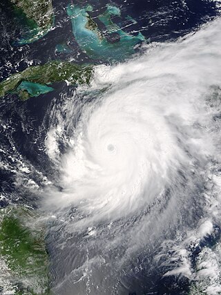
Hurricane Emily was a powerful early season Cape Verde hurricane that caused significant damage across the Caribbean to Mexico. It was also the earliest-forming Category 5 Atlantic hurricane on record in a season and the most intense to form before August. At the time, Emily was the earliest-forming fifth named storm in the Atlantic on record; this record has since been surpassed by 2020's Tropical Storm Edouard, and again the following year by 2021's Hurricane Elsa. After forming on July 10, 2005, the storm moved through the central Atlantic Ocean before passing through the Windward Islands on July 14. Tracking generally towards the west-northwest, the storm gradually intensified as it traversed the Caribbean, peaking as a Category 5 hurricane on July 16, marking the earliest date for a storm to do so during the course of a given year. The system subsequently made landfall in the Yucatán Peninsula as a Category 4. Quickly crossing the peninsula, Emily emerged into the Gulf of Mexico and reorganized. On July 20, the storm struck Tamaulipas as a major hurricane and rapidly dissipated within 24 hours. The storm caused significant damage along its path, with up to $1.01 billion in damages recorded, primarily in Mexico. 5 people died in each of Jamaica, Haiti, and Mexico; 2 people died elsewhere, for a total of 17 fatalities.
The 'Economy of the Caribbean' is varied, but depends heavily on natural resources, agriculture and travel and tourism.

Dessima D Williams is a Grenadian diplomat and former Ambassador to the United Nations from Grenada who was reappointed to the ambassadorship in 2008. Since 2022 she has been President of the Senate.

In September 2004, Hurricane Ivan caused significant effects in the Lesser Antilles and South America, including 44 deaths and over $1 billion in damage (2004 USD), primarily in Grenada where it was considered the worst hurricane in nearly 50 years. Hurricane Ivan developed from a tropical wave on September 2 and rapidly intensified to become a major hurricane, passing through the southern Lesser Antilles on September 7 with winds of 125 mph (201 km/h). At the time, its typical storm force winds extended outward up to 160 miles (260 km) with hurricane-force winds outward to 70 miles (110 km), and the northern portion of the eye passed over Grenada.

Tourism is one of the Caribbean's major economic sectors, with 25 million visitors contributing $49 billion towards the area's gross domestic product in 2013, which represented 14% of its total GDP. It is often described as, "the most tourism-dependent region in the world".

Grenada is an island country of the West Indies in the eastern Caribbean Sea. The southernmost of the Windward Islands, Grenada is directly south of Saint Vincent and the Grenadines and about 100 miles (160 km) north of Trinidad and the South American mainland.
In 2015, in Grenada, 97% of the total population had access to "improved" water, 99% in urban areas and 95% in rural areas. In the same year, 98% had access to "improved" sanitation, 98% both in urban and rural areas. Nevertheless, there were still, in 2015, around 4 thousand people without access to "improved" water and around 2 thousand without access to "improved" sanitation.

The effects of climate change on small island countries are affecting people in coastal areas through sea level rise, increasing heavy rain events, tropical cyclones and storm surges. These effects of climate change threaten the existence of many island countries, their peoples and cultures. They also alter ecosystems and natural environments in those countries. Small island developing states (SIDS) are a heterogenous group of countries but many of them are particularly at risk to climate change. Those countries have been quite vocal in calling attention to the challenges they face from climate change. For example, the Maldives and nations of the Caribbean and Pacific Islands are already experiencing considerable impacts of climate change. It is critical for them to implement climate change adaptation measures fast.
Caribbean Catastrophe Risk Insurance Facility Segregated Portfolio Company is an insurance company headquartered in the Cayman Islands. The sixteen original member-countries of CCRIF included participants in CARICOM, and the membership of the Board of Directors is selected by CARICOM and by the Caribbean Development Bank.

Climate change has had large impacts on the ecosystems and landscapes of the US territory Puerto Rico. According to a 2019 report by Germanwatch, Puerto Rico is the most affected by climate change. The territory's energy consumption is mainly derived from imported fossil fuels.

Climate changein the Caribbean poses major risks to the islands in the Caribbean. The main environmental changes expected to affect the Caribbean are a rise in sea level, stronger hurricanes, longer dry seasons and shorter wet seasons. As a result, climate change is expected to lead to changes in the economy, environment and population of the Caribbean. Temperature rise of 2 °C above preindustrial levels can increase the likelihood of extreme hurricane rainfall by four to five times in the Bahamas and three times in Cuba and Dominican Republic. Rise in sea level could impact coastal communities of the Caribbean if they are less than 3 metres (10 ft) above the sea. In Latin America and the Caribbean, it is expected that 29–32 million people may be affected by the sea level rise because they live below this threshold. The Bahamas is expected to be the most affected because at least 80% of the total land is below 10 meters elevation.

The nations of Grenada and Mexico established diplomatic relations in 1975. Both nations are members of the Association of Caribbean States, Community of Latin American and Caribbean States, Organization of American States and the United Nations.

Climate change in Fiji is an exceptionally pressing issue for the country - as an island nation, Fiji is particularly vulnerable to rising sea levels, coastal erosion and extreme weather. These changes, along with temperature rise, will displace Fijian communities and will prove disruptive to the national economy - tourism, agriculture and fisheries, the largest contributors to the nation's GDP, will be severely impacted by climate change causing increases in poverty and food insecurity. As a party to both the Kyoto Protocol and the Paris Climate Agreement, Fiji hopes to achieve net-zero emissions by 2050 which, along with national policies, will help to mitigate the impacts of climate change.
