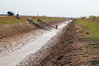
Deforestation or forest clearance is the removal of a forest or stand of trees from land that is then converted to non-forest use. Deforestation can involve conversion of forest land to farms, ranches, or urban use. The most concentrated deforestation occurs in tropical rainforests. About 31% of Earth's land surface is covered by forests at present. This is one-third less than the forest cover before the expansion of agriculture, with half of that loss occurring in the last century. Between 15 million to 18 million hectares of forest, an area the size of Bangladesh, are destroyed every year. On average 2,400 trees are cut down each minute.

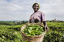
The Geography of Kenya is diverse, varying amongst its 47 counties. Kenya has a coastline on the Indian Ocean, which contains swamps of East African mangroves. Inland are broad plains and numerous hills. Kenya borders South Sudan to the northwest, Uganda to the west, Somalia to the east, Tanzania to the south, and Ethiopia to the north and currently facing border disputes with South Sudan over the Ilemi Triangle and the dispute over Jubbaland in Somalia where if the Somalian Government gives it up it could be a new part of Kenya bringing the total land area of Kenya to approximately to 692,939km2.

Uganda is located in eastern Africa, west of Kenya, south of South Sudan, east of the Democratic Republic of the Congo, and north of Rwanda and Tanzania. While much of its border is lakeshore, Uganda is landlocked with no access to the sea but it is a fertile and well-watered country that consists of many lakes and rivers including the largest, Lake Victoria. The country sits in the heart of the Great Lakes region, with Lake Edward and Lake Albert on its western border.

The Ruwenzori, also spelled Rwenzori and Rwenjura, or Rwenzururu are a range of mountains in eastern equatorial Africa, located on the border between Uganda and the Democratic Republic of the Congo. The highest peak of the Ruwenzori reaches 5,109 metres (16,762 ft), and the range's upper regions are permanently snow-capped and glaciated. Rivers fed by mountain streams form one of the sources of the Nile. Because of this, European explorers linked the Ruwenzori with the legendary Mountains of the Moon, claimed by the Greek scholar Ptolemy as the source of the Nile. Virunga National Park in eastern DR Congo and Rwenzori Mountains National Park in southwestern Uganda are located within the range.

Environmental degradation is the deterioration of the environment through depletion of resources such as quality of air, water and soil; the destruction of ecosystems; habitat destruction; the extinction of wildlife; and pollution. It is defined as any change or disturbance to the environment perceived to be deleterious or undesirable.

Environmental issues in Nepal include a number of issues, such as deforestation, climate change, energy and species conservation. Many of these issues have been precipitated by rapid industrialization without major environmental regulation.

African environmental issues are caused by human impacts on the natural environment and affect humans and nearly all forms of life. Issues include deforestation, soil degradation, air pollution, water pollution, garbage pollution, climate change and water scarcity. These issues result in environmental conflict and are connected to broader social struggles for democracy and sovereignty.

Climate change in South Asia is having significant impacts already which are expected to intensify as global temperatures rise due to climate change. The South Asia region consists of the eight countries: Afghanistan, Pakistan, India, Nepal, Bhutan, Bangladesh, the Maldives and Sri Lanka. In the 2017 edition of Germanwatch's Climate Risk Index, Bangladesh and Pakistan ranked sixth and seventh respectively as the countries most affected by climate change in the period from 1996 to 2015, while India ranked fourth among the list of countries most affected by climate change in 2015. The Indian subcontinent is one of the most vulnerable regions globally to a number of direct and indirect effects of climate change, including sea level rise, cyclonic activity, and changes in ambient temperature and precipitation patterns. Ongoing sea level rise has already submerged several low-lying islands in the Sundarbans region, displacing thousands of people.

Brazil once had the highest deforestation rate in the world and in 2005 still had the largest area of forest removed annually. Since 1970, over 700,000 square kilometres (270,000 sq mi) of the Amazon rainforest have been destroyed. In 2001, the Amazon was approximately 5,400,000 square kilometres (2,100,000 sq mi), which is only 87% of the Amazon's original size. According to official data, about 729,000 km² have already been deforested in the Amazon biome, which corresponds to 17% of the total. 300,000 km² have been deforested in the last 20 years.
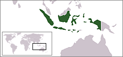
The environment of Indonesia consists of 17,508 islands scattered over both sides of the equator. Indonesia's size, tropical climate, and archipelagic geography, support the world's second highest level of biodiversity after Brazil.

The 2010 Ugandan landslide occurred in the Bududa District in eastern Uganda on 1 March 2010. The landslide was triggered by heavy rain between 12 pm and 7 pm that day. At least 100 people were believed to have been killed, and 94 bodies were found.

Climate change in Africa is an increasingly serious threat as Africa is among the most vulnerable continents to the effects of climate change. Some sources even classify Africa as "the most vulnerable continent on Earth". This vulnerability is driven by a range of factors that include weak adaptive capacity, high dependence on ecosystem goods for livelihoods, and less developed agricultural production systems. The risks of climate change on agricultural production, food security, water resources and ecosystem services will likely have increasingly severe consequences on lives and sustainable development prospects in Africa. With high confidence, it was projected by the IPCC in 2007 that in many African countries and regions, agricultural production and food security would probably be severely compromised by climate change and climate variability. Managing this risk requires an integration of mitigation and adaptation strategies in the management of ecosystem goods and services, and the agriculture production systems in Africa.
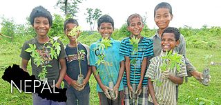
Globally, Nepal is ranked fourth in terms of vulnerability to climate change. Floods spread across the foothills of the Himalayas and bring landslides, leaving tens of thousands of houses and vast areas of farmland and roads destroyed. In the 2020 edition of Germanwatch's Climate Risk Index, it was judged to be the ninth hardest-hit nation by climate calamities during the period 1999 to 2018. Nepal is a least developed country, with 28.6 percent of the population living in multidimensional poverty. Analysis of trends from 1971 to 2014 by the Department of Hydrology and Meteorology (DHM) shows that the average annual maximum temperature has been increasing by 0.056 °C per year. Precipitation extremes are found to be increasing. A national-level survey on the perception-based survey on climate change reported that locals accurately perceived the shifts in temperature but their perceptions of precipitation change did not converge with the instrumental records. Data reveals that more than 80 percent of property loss due to disasters is attributable to climate hazards, particularly water-related events such as floods, landslides and glacial lake outburst floods (GLOFs).

Climate change is having serious impacts in the Philippines such as increased frequency and severity of natural disasters, sea level rise, extreme rainfall, resource shortages, and environmental degradation. All of these impacts together have greatly affected the Philippines' agriculture, water, infrastructure, human health, and coastal ecosystems and they are projected to continue having devastating damages to the economy and society of the Philippines.
Cambodia is highly vulnerable to the effects of climate change. Extreme weather events will occur more frequently; this includes floods, which already affect 90,000 residents annually, and heatwaves, with Cambodia already having one of the highest temperatures of the world. The temperature has increased since the 1960s by 0.18 °C per decade. It had the 7th lowest CO2 emissions in Asia in 2019.
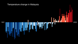
Climate change is having a considerable impact in Malaysia. Increasing temperatures are likely to greatly increase the number of heatwaves occurring annually. Variations in precipitation may increase the frequency of droughts and floods in various local areas. Sea level rise may inundate some coastal areas. These impacts are expected to have numerous environmental and socioeconomic effects, exacerbating existing environmental issues and reinforcing inequality.

Climate change is a significant threat to Madagascar's environment and people. Climate change has raised temperatures, made the dry season longer and has resulted in more intense tropical storms. The country's unique ecosystems, animal and plant life are being impacted.

Climate change is posing an increasing threat to global socio-economic development and environmental sustainability. Developing countries with low adaptive capacity and high vulnerability to the phenomenon are disproportionately affected. Climate change in Kenya is increasingly impacting the lives of Kenya's citizens and the environment. Climate Change has led to more frequent extreme weather events like droughts which last longer than usual, irregular and unpredictable rainfall, flooding and increasing temperatures.

Due to its geographical and natural diversity, Indonesia is one of the countries most susceptible to the impacts of climate change. This is supported by the fact that Jakarta has been listed as the world's most vulnerable city, regarding climate change. It is also a major contributor as of the countries that has contributed most to greenhouse gas emissions due to its high rate of deforestation and reliance on coal power.

Climate change in Nigeria is evident from temperature increase, rainfall variability. It is also reflected in drought, desertification, rising sea levels, erosion, floods, thunderstorms, bush fires, landslides, land degradation, more frequent, extreme weather conditions and loss of biodiversity. All of which continues to negatively affect human and animal life and also the ecosystems in Nigeria. Although, depending on the location, regions experience climate change with significant higher temperatures during the dry seasons while rainfalls during rainy seasons help keep the temperature at milder levels. The effects of climate change prompted the World Meteorological Organization, in its 40th Executive Council 1988, to establish a new international scientific assessment panel to be called the International Panel on Climate Change (IPCC). The 2007 IPCC's fourth and final Assessment Report (AR4) revealed that there is a considerable threat of climate change that requires urgent global attention. The report further attributed the present global warming to largely anthropogenic practices. The Earth is almost at a point of no return as it faces environmental threats which include atmospheric and marine pollution, global warming, ozone depletion, the dangers of pollution by nuclear and other hazardous substances, and the extinction of various wildlife species.