Ntungamo District is a district in Western Uganda. Like most Ugandan districts, it is named after its 'chief town', Ntungamo, the location of the district headquarters. Ntungamo was elevated to a district on 5th May 1993.

The Bwindi Impenetrable National Park is a national park in southwestern Uganda. It is part of the Bwindi Impenetrable Forest and is situated along the Democratic Republic of the Congo border next to the Virunga National Park and on the edge of the Albertine Rift. Composed of 321 km2 (124 sq mi) of both montane and lowland forest, it is accessible only on foot. It is a United Nations Educational, Scientific and Cultural Organization-designated World Heritage Site.

Mukono is one of the districts in the Central Region of Uganda. The town of Mukono serves as the district headquarters and is home to the district's main commercial center.

Yumbe District is a district in Northern Region, Uganda. Like most other Ugandan districts, it is named after its 'chief town', Yumbe, where the district headquarters are located.

Kabale District is a district in the Western Region of Uganda. Kabale hosts the district headquarters. It was originally part of Kigezi District, before the districts of Rukungiri, Kanungu, Kisoro, Rubanda and Rukiga were excised to form separate districts. Kabale is sometimes nicknamed "Kastone" as in the local language Rukiga, a "kabale" is a small stone.

Kanungu District is a district in the Western Region of Uganda. The town of Kanungu is the site of the district headquarters. The Bwindi Impenetrable Forest in Kanungu District is among the sites shown in aerial footage in the movie Black Panther.
Kisoro is a town in the Western Region of Uganda. It is the chief town of Kisoro District and the site of the district headquarters.

Kabale is a town in the Western Region of Uganda. It is the chief town of Kabale District, and the district headquarters are located there.

Bundibugyo is a town in the Western Region of Uganda. It is the 'chief town' of Bundibugyo District and the district headquarters are located there.

Kigezi District once covered what are now Kabale District, Kanungu District, Kisoro District and Rukungiri District, in southwest Uganda. Its terraced fields are what gives this part of Uganda its distinctive character. Kigezi was popularly known as the Switzerland of Africa. The coordinates for the region are: Latitude:01 13 20S, 29 53 20E.
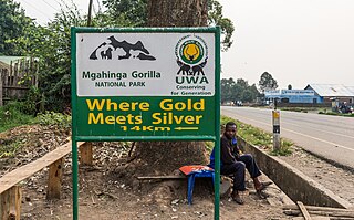
Mgahinga Gorilla National Park is a national park in southwestern Uganda. It was created in 1991 and covers an area of 33.9 km2 (13.1 sq mi).
Ntungamo is a town in the Western Region of Uganda. It is the largest town in Ntungamo District and the site of the district headquarters.

Buliisa District is a district in Western Uganda. As with most Ugandan districts, Buliisa District is named after its "main town" Buliisa, where the district headquarters are located. Bugungu has 6 sub counties: Kigwera, Ngwedo, Buliisa, Butiaba, Kihungya, and Biiso. It also contain 3 town councils: Buliisa, Butiaba and Biiso.
Mpondwe is a town in the Western Region of Uganda.
Echuya Batwa, commonly known as pygmies, are an endangered group of people around Echuya Forest Reserve in Kisoro and Kabale Districts of South-Western Uganda. The Echuya is located in the Albertine Rift region recognized as an important eco-region. The Batwa are believed to have migrated from the Ituri Forest of the Democratic Republic of Congo in search of wild animals to hunt, hence the name Kisoro, literally meaning "the area occupied by wild animals". The Batwa live in small huts mainly made from sticks and grass, and number 6,700 per a 2014 estimate by the Uganda Bureau of Statistics.
Bunagana is a town in the Western Region of Uganda. It sits across the international border from the similarly named town of Bunagana, Democratic Republic of the Congo.
Saint Francis Hospital, Mutolere, commonly referred to as Mutolere Hospital, is a private, community hospital, in Mutolere, Kisoro District, in the Western Region of Uganda.
Sanga, is an urban center in the Kiruhura District, Ankole sub-region, in the Western Region of Uganda.
The Kabale–Kisoro–Bunagana Road in Western Uganda connects the town of Kabale with the towns of Kisoro, Bunagana, at the border with the Democratic Republic of the Congo and with Kyanika, at the border with Rwanda.

Rubanda District is a district in the Western Region of Uganda. The largest town in the district, Rubanda, serves as the main administrative and commercial center in the district.
