Kabarole District

Last updated

Kabarole District
Weather in Fort Portal Kabarole District.jpg
Kabarole District in Uganda.svg
District location in Uganda
Coordinates: 00°36′N30°18′E / 0.600°N 30.300°E / 0.600; 30.300
CountryFlag of Uganda.svg  Uganda
Region Western Uganda
Sub-region Toro sub-region
Capital Busoro town council proporsed after elevating Fort Portal Municipality to a City on 1 July 2020 hence separating it from Kabarole district
Government
  LC5 ChairpersinSir Rwabuhinga Richard
Area
  Total1,814 km2 (700 sq mi)
Population
 (2012 Estimate)
  Total415,600
Time zone UTC+3 (EAT)
Website www.kabarole.go.ug

Kabarole District is a district in Western Uganda. Kabarole District is part of the Tooro Kingdom. Its main town was Fort Portal before 1 July 2020 when it was elevated to a city, separating it from Kabarole district Government. The new Kabarole district seat is proporsed in Busoro Town Council. Kabarole remains with only one county (Burahya). Bunyangabu county was curved out to form Bunyangabu district in 2017. Fort Portal Municipality constituency became Fort Portal City in 2020 with an independent local Government.

Contents

Location

Kabarole District is bordered by Ntoroko District to the north, Kibaale District to the northeast, Kyenjojo District to the east, Kamwenge District to the southeast, Bunyangabu District (which was formerly a county of Kabarole District) to the south, the Democratic Republic of the Congo to the southwest and Bundibugyo District, across the Rwenzori Mountains to the west. Fort Portal, the 'chief town' (Uganda's Tourism City) in the district, lies approximately 320 kilometres (200 mi), by road, west of Kampala, the capital city of Uganda. [1] The coordinates of the district are:00 36N, 30 18E (Latitude:0.6000; Longitude:30.3000). The surface area is 1,814 km2. [2]

Overview

Kabarole Districts consists of one city and One county: [3]

(a) Fort Portal City and (b) Buryahya County. Bunyangabu District which was one of the three counties of Kabarole District got a district started effective 1 July 2017 leaving Kabarole District with just two counties.

Population

In 1991, the national census put the population of the district at about 299,600. During the 2002 national census, the district population was about 357,000. In 2012, the population of Kabarole District was estimated at about 415,600. [4]

Ethnicities

The Batooro, Batuku and Basongora ethnicities constitute about 52% of the population. The Bakiga constitute 28%, followed by the Bakonjo and the Bamba. The major languages spoken in the district are Rutooro, Rukiga and Runyankore. [5]

Economic activities

Subsistence agriculture and animal husbandry are the main economic activities in Kabarole District.

The crops grown in Kabarole District include:

Livestock is the second economic activity practiced in the district. In 2005, there were approximately 18,695 heads of exotic/cross bred cattle, 35,199 indigenous cattle, 75,897 goats, 6,442 sheep, 12,162 pigs, 9,776 exotic/cross bred chicken, 131,255 local chicken, 4,467 ducks, 1,040 turkeys, 326 guinea fowl, and 122 geese in the district.

Commercial fishing occurs on about 30 of the 52 crater lakes, scattered in Kabarole District. The main fish species harvested from the crater lakes is the small Haplochromines (Nkejje). Fishing, mainly of Protopterus aethiopicus (Lung fish), is also carried out in a number of wetlands. Some fishing also goes on in the area rivers including:

Aquaculture is practiced with increasing frequency in the district and in 2005 there were over 300 fish ponds stocked with tilapia and mirror carp species. [6]

See also

Related Research Articles

<span class="mw-page-title-main">Mbarara district</span> District in Western Uganda, Uganda

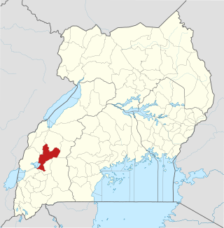
Mbarara District is a district in South Western Uganda. In 2019 Uganda cabinet approved part of Mbarara the then Mbarara municipality to be upgraded to a city status in July 2020.

<span class="mw-page-title-main">Bundibugyo District</span> District in Western Uganda, Uganda

Bundibugyo District is a district in the Western Region of Uganda, bordering the Democratic Republic of the Congo (DRC). The town of Bundibugyo is where both the district headquarters and the Bwamba Kingdom seat are located. Before July 2010, the districts of Ntoroko and Bundibugyo were one. These districts are the only two in Uganda that lie west of the Rwenzori mountains. Bundibugyo was first named Semuliki district on separating it from the Greator Kabarole district alongside Rwenzori district (Kasese) in 1974.

<span class="mw-page-title-main">Kamwenge District</span> District in Western Uganda, Uganda

Kamwenge District is a district in Western Uganda. It is named after its 'chief town', Kamwenge, where the district headquarters are located. Kamwenge District is part of the Kingdom of Toro, one of the ancient traditional monarchies in Uganda. The kingdom is coterminous with Toro sub-region. The districts that constitute the sub-region are: (a) Bunyangabu District (b) Kabarole District (c) Kamwenge District (d) Kyegegwa District (e) Kitagwenda District and (f) Kyenjojo District.

<span class="mw-page-title-main">Kasese District</span> District in Western Uganda, Uganda

Kasese District is a district in Western Uganda. Like most other Ugandan districts, the town of Kasese is the site of the district headquarters.

<span class="mw-page-title-main">Kyenjojo District</span> District in Western Region of Uganda, Uganda

Kyenjojo District is a district in the Western Region of Uganda. Kyenjojo town is the site of the district headquarters.

<span class="mw-page-title-main">Fort Portal</span> Place in Western Region, Uganda

Fort Portal or Kabarole is a city located in the Western Region of Uganda. It is the seat of both Kabarole District and historically of the Tooro Kingdom.

<span class="mw-page-title-main">Amolatar District</span> District in Northern Uganda, Uganda

Amolatar District is a district in Northern Uganda. Like many other Ugandan districts, it is named after its main municipal and administrative centre, Amolatar Town.

<span class="mw-page-title-main">Nakaseke District</span> District in Uganda

Nakaseke District is a district in Central Uganda. It is named after Nakaseke, the largest town in the district. However, the district headquarters are located at Butalangu.

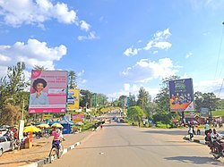
Rwimi is a town in Bunyangabu District in the Western Region of Uganda. With an estimated population of 16,200 in 2020 it is the largest urban center in the district, but the district headquarters are located elsewhere; in Kibiito.

Adolf Kasaija Mwesige is a Ugandan lawyer and politician who served as Minister of Defence and Veterans Affairs in the Cabinet of Uganda from 6 June 2016 to 8 June 2021. He previously served as Minister of Local Government from 18 February 2009 to 6 June 2016. He has also been the elected Member of Parliament for Bunyangabu County, Kabarole District, since 1996. In July 2017, Bunyangabu County was peeled off Kabarole District to form Bunyangabu District.

<span class="mw-page-title-main">Kyegegwa District</span> District in Western Region, Uganda

Kyegegwa District is a district in Western Region of Uganda. The town of Kyegegwa hosts the district headquarters.

<span class="mw-page-title-main">Tooro people</span> Bantu ethnic group in Uganda

The Tooro people, also known as Batooro or Toro people are a Bantu ethnic group, native to the Tooro Kingdom, a subnational constitutional monarchy within Uganda.

Peace Regis Mutuuzo is a Ugandan politician who serves as the Women representative for Bunyangabu District. She is the Minister of State for Gender and Culture in the Ugandan Cabinet. She was appointed to that position on 6 June 2016. In 2021, she was re elected into the eleventh Uganda Parliament.

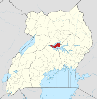
Bunyangabu District is a district in the Western Region of Uganda. The town of Kibiito is the political and administrative center of the district. However, the town of Rwimi, is the largest and main commercial center of Bunyangabu.

Kibiito is a town in the Western Region of Uganda. It is the chief administrative center of Bunyangabu District, and the district headquarters are located there.

Rubona is a town in the Western Region of Uganda.

The Nkenda–Fort Portal–Hoima High Voltage Power Line is a high voltage electricity power line, in operation, connecting the high voltage substation at Nkenda, Kasese District, to another high voltage substation at Kabaale, Buseruka sub-county, Hoima District, all in the Western Region of Uganda.

<span class="mw-page-title-main">Kitagwenda District</span> Ugandan district

Kitagwenda District is a district in Western Uganda. The district is named after Kitagwenda County, which is coterminous with the district.

Kabujogera is a settlement in Kitagwenda District, in Western Uganda. It is one of the two municipalities in the newly created Kitagwenda District, the other being Ntara Town Council, where the district headquarters are located.

Karago was a municipality in the Western Region of Uganda. In 2019, Karago was annexed by the city of Fort Portal, as part of the award of Tourism City status. It became a neighborhood in the Northern Division of Fort Portal City.

References

  1. "Road Distance Between Fort Portal And Kampala With Map". Globefeed.com. Retrieved 2 April 2014.
  2. "Additional district profile narratives" (PDF). mmv.org. Retrieved 8 October 2016.
  3. "Overview of Kabarole District" (PDF). International Food Policy Research Institute. Archived from the original (PDF) on 5 September 2012. Retrieved 21 April 2014.
  4. "Estimated Population of Kabarole District In 1991, 2002 & 2012". Citypopulation.de. Retrieved 21 April 2014.
  5. "Demographics of Kabarole District" (PDF). International Food Policy Research Institute. Archived from the original (PDF) on 5 September 2012. Retrieved 21 April 2014.
  6. "The Economy of Kabarole District" (PDF). International Food Policy Research Institute. Archived from the original (PDF) on 5 September 2012. Retrieved 21 April 2014.