Buikwe District

Last updated

Buikwe District
Buikwe District in Uganda.svg
District location in Uganda
Coordinates: 00°21′N33°02′E / 0.350°N 33.033°E / 0.350; 33.033
CountryFlag of Uganda.svg  Uganda
Region Central Uganda
Capital Buikwe
Area
  Land1,244.7 km2 (480.6 sq mi)
Population
 (2012 Estimate)
  Total429,600
  Density345.1/km2 (894/sq mi)
Time zone UTC+3 (EAT)
Website www.buikwe.go.ug

Buikwe District is a district in the Central Region of Uganda. It is named after its 'chief town', Buikwe, where the district headquarters are located.

Contents

Location

Buikwe District is bordered by Kayunga District to the north, Jinja District to the east, Buvuma District to the southeast, the Republic of Tanzania to the south and Mukono District to the west. The district headquarters at Buikwe are located approximately 60 kilometres (37 mi), by road, east of Kampala, the capital of Uganda and the country's largest city. [1] This location is approximately 14 kilometres (8.7 mi), by road, southeast of Lugazi, the nearest large town. [2] The coordinates of the district are:00 21N, 33 02E.

Overview

Buikwe District was created by an Act of Parliament and it commenced operations on 1 July 2009. Prior to that, it was part of Mukono District. [3]

Population

The 1991 national population census estimated the district population at about 250,500. The national census in 2002 estimated the population of Buikwe District at approximately 329,900. In 2012, the population of the district was estimated at 429,600. [4]

Tourist Attractions

Mabira Forest Reserve

Mabira forest is located in the tropics north of the shoreline of Lake Victoria, immediately to the west of the River Nile. Mabira covers an area of 306 square kilometres (118 sq mi). It is the biggest forest reserve in central Uganda and one of the few surviving rainforests remaining in Uganda.

Mabira is well known for Ecotourism which started in the early 1980s. The forest harbors in excess of 300 species of birds, many of which are rare; including the pied hornbill, superb sunbird, grey parrot, crowned eagle, black-billed turacos and the endangered Nahan's Frankolin. There are over 300 plant species, some of which are of medicinal value.

Among the services offered to tourists are guided forest walks, camping sites, picnic sites and environmental education and entertainment with local drama groups. There is a network of trails to facilitate the exploration of the forest.

River Nile

The Nile is the world's second-longest river, measuring an estimated 4,000 miles (6,400 km) in length. It starts its journey on the outskirts of Jinja and traverses Uganda, southern Sudan, Sudan and Egypt to empty into the Mediterranean Sea at Alexandria. The river is of great geographical and historical importance locally and internationally.

In Uganda, the Nile has cultural importance as well as economic significance. Many communities along its shores derive their livelihood from fishing its waters. At its point of origin, Uganda has built three hydroelectric dams which provide electricity to many citizens in Uganda and neighboring countries. Uganda plans three other dams further upstream later in the present decade. In Sudan and Egypt, the river is considered to be the 'source of life' as its waters are used for irrigation and the support of agriculture for multitudes of people living along the river since time immemorial.

The Source of the Nile

River Nile forms the border between Njeru in Buikwe District on the west and Jinja, Uganda in Jinja District on the east. At this point, the river flows from Lake Victoria to begin its three-months journey to the Mediterranean Sea. This point, viewed from Njeru, is visited by tourists and holidaymakers for its scenery.[ citation needed ] The 32 metres (105 ft) deep waterfalls that John Hanning Speke saw in 1862 and named "Ripon Falls" were submerged when construction on Nalubaale Dam began in 1947. The dam was completed in 1954.

See also

Related Research Articles

<span class="mw-page-title-main">Jinja, Uganda</span> Place in Eastern Region, Uganda

Jinja is a city in the Eastern Region of Uganda, located on the north shore of Lake Victoria.

<span class="mw-page-title-main">Kayunga District</span> District in Central Uganda, Uganda

Kayunga District is a district in Central Uganda. It is named after its chief town, Kayunga.

<span class="mw-page-title-main">Mukono District</span> District in Central Region of Uganda, Uganda

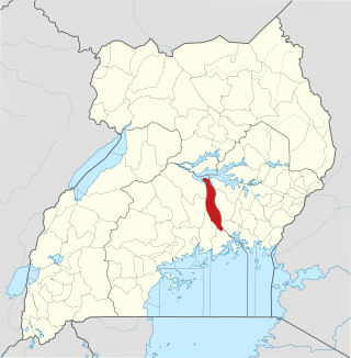
Mukono is one of the districts in the Central Region of Uganda. The town of Mukono serves as the district headquarters and is home to the district's main commercial center.

Kisoga is a town in Mukono District in Central Uganda.

<span class="mw-page-title-main">Mabira Forest</span>

The Mabira Forest is a rainforest area covering about 300 square kilometres (120 sq mi) in Uganda, located in Buikwe District, between Lugazi and Jinja. It has been protected as Mabira Forest Reserve since 1932. It is home for many endangered species like the primate Lophocebus ugandae.

<span class="mw-page-title-main">Mukono Town</span> Urban centre in Uganda

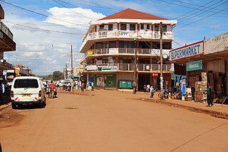
Mukono Town is a municipality in Mukono District in the Central Region of Uganda. The town is administered by the Mukono Town Council. The district headquarters are located in this town.

Njeru is a town in Buikwe District, in the Central Region of Uganda. It is the largest town in the district. It is mainly a residential town. However, it hosts industries such as East African Packaging Solutions Limited, a manufacturer of paper packaging supplies, Nile Breweries Limited, a subsidiary of AB InBev and Nyanza Textile Industries Limited (Nytil), a textile manufacturer.

Lugazi is a town in the Buikwe District of the Central Region of Uganda. The town is also called "Kawolo", and the two names are interchangeably used by the local inhabitants.

The Kampala–Jinja Highway is a road in Uganda, connecting the cities of Kampala and Jinja. Sometimes referred to as Kampala–Jinja Road, it is a busy road, with several towns, trading centers and other points of interest along the way. As of October 2016, a new, wider, four-lane dual carriageway expressway, the Kampala–Jinja Expressway, is proposed to be constructed south of the present highway to relieve traffic and complement existing transport infrastructure between Kampala and Jinja.

<span class="mw-page-title-main">Sezibwa River</span> River in Uganda

The Sezibwa River is a river in Central Uganda, in East Africa. The name is derived from the Luganda phrase "sizibwa kkubo", which translates into "my path cannot be blocked".

Nkokonjeru is a town council in Buikwe District in the Central Region of Uganda with villages such as: Namaliiri, Kigulu, Mulajje, Naziwanga, Ndolwa, Buira, Bukasa, Wabiduuku, Nsuube and Nkokonjeru Central. The town's name means "White Chicken".

<span class="mw-page-title-main">Buvuma District</span> District in Central Uganda, Uganda

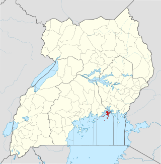
Buvuma District is a district in the Central Region of Uganda. The district is coterminous with the Buvuma Islands archipelago in Lake Victoria and does not have territory on mainland Uganda.

Sugar Corporation of Uganda Limited (SCOUL) is a sugar manufacturer in Uganda, the third-largest economy in the East African Community.

St. Francis Hospital Nkokonjeru, commonly referred to as Nkokonjeru Hospital, is a private, non-profit, community hospital in Uganda. It is owned by the Roman Catholic Diocese of Lugazi.

Nyenga is an urban division of one of the municipalities in Buikwe District, in the Central Region of Uganda. Nyenga Division is one of the three divisions of the city of Njeru. The other two divisions are Wakisi Division and Njeru Division.

Nile Breweries Limited (NBL) is the leading beer manufacturer in Uganda.

The Mukono–Kyetume–Katosi–Nyenga Road is a road in the Central Region of Uganda, connecting the towns of Mukono, Kyetume and Katosi in Mukono District to Nkokonjeru and Nyenga in Buikwe District.

Nyanza Textile Industries Limited(Nytil), is an integrated textile manufacturing company in Uganda.

Kawolo General Hospital, also Kawolo Hospital, is a hospital in Buikwe District in the Central Region of Uganda.

Nyenga Mission Hospital, whose formal name is St. Francis Hospital Nyenga, but is commonly referred to as Nyenga Hospital, is a non-profit, community hospital in Uganda. It is owned and operated by the Roman Catholic Diocese of Lugazi.

References

  1. "Road Distance Between Kampala And Buikwe With Map". Globefeed.com. Retrieved 18 April 2014.
  2. "Map Showing Lugazi And Buikwe With Distance Marker". Globefeed.com. Retrieved 18 April 2014.
  3. Vision, Reporters (22 April 2010). "Government Names 14 New Districts". New Vision. Archived from the original on 29 October 2013. Retrieved 18 April 2014.
  4. "Estimated Population of Buikwe District In 1991, 2002 & 2012". Citypopulation.de. Retrieved 16 May 2014.