Buvuma District

Last updated
Buvuma District
Buvuma
Buvuma District in Uganda.svg
District location in Uganda
Coordinates: 00°14′N33°16′E / 0.233°N 33.267°E / 0.233; 33.267 Coordinates: 00°14′N33°16′E / 0.233°N 33.267°E / 0.233; 33.267
CountryFlag of Uganda.svg  Uganda
Region Central Uganda
Capital Kitamilo [1]
Area
  Land218.3 km2 (84.3 sq mi)
Elevation
1,340 m (4,400 ft)
Population
 (2014 NPHC)
  Total89,890
  Density253.3/km2 (656/sq mi)
Time zone UTC+3 (EAT)
Website www.buvuma.go.ug

Buvuma District is a district in the Central Region of Uganda. The district is coterminous with the Buvuma Islands archipelago in Lake Victoria and does not have territory on mainland Uganda.

Contents

Location

Buvuma District is bordered by Jinja District to the north, Mayuge District to the east, Tanzania to the south, and Buikwe District to the west and northwest. Kitamilo, the district headquarters, is approximately 30 kilometres (19 mi) south of the city of Jinja, the nearest large metropolitan area. [2]

Overview

Buvuma District is made up of 52 scattered islands in the northern part of Lake Victoria. The largest island is called Buvuma, the name adopted by the new district, which was created by Act of Parliament on 1 July 2010. Before that, it was part of Mukono District. [3] Administratively, the district is subdivided into nine administrative units:[ citation needed ]

  1. Bugaya Sub-county
  2. Busamuzi Sub-county
  3. Bweema Sub-county
  4. Nairambi Sub-county
  5. Buvuma Town Council
  6. Buwooya Sub-County
  7. Lwajje Sub-County
  8. Lubya Sub-county
  9. Lyabaana Sub-county

Population

In 1991, the national population census estimated the population of the district at 18,500. During the 2002 national census, the population of Buvuma District was estimated at 42,500. In the 2014 National Population and Housing Census, the population stood at 89,890. [4]

Economic activities

Women gathering and collecting charcoal from kilns for home use. Buvuma women.jpg
Women gathering and collecting charcoal from kilns for home use.

The four main activities in the district are: (a) Fishing (b) Tourism (c) Logging and (d) Manufacture of charcoal. Subsistence agriculture is practiced by the inhabitants of the islands. The majority of the islanders depend a lot on fishing. Overfishing is a concern. The district has twenty-six gazetted forest reserves, although many are threatened by unregulated logging and burning to make charcoal. Little livestock farming is practiced in the district, with the majority of livestock consumed locally in the district. [5] [6]

See also

Related Research Articles

Ssese Islands

The Ssese Islands are an archipelago of eighty-four islands in the northwestern part of Lake Victoria in Uganda. The islands are coterminous with the Kalangala District in southern Central Uganda, which does not have any territory on mainland Uganda.

Jinja, Uganda Place in Eastern Region, Uganda

Jinja is a city in the Eastern Region of Uganda, located on the North shores of Lake Victoria.

Kalangala District District in Uganda

Kalangala, also known as Ssesse, is a district in Central Uganda. The district is coterminous with the Ssese Islands in Lake Victoria and does not have territory on mainland Uganda. Like other Ugandan districts, it is named after its 'chief town', Kalangala which is located on Bugala Island, the largest of the Ssese Islands.

Wakiso District District in Uganda

Wakiso District is a district in the Central Region of Uganda that partly encircles Kampala, Uganda's capital city. The town of Wakiso is the site of the district headquarters. Kira, the country's second largest city and suburb of Kampala, is in the district.

Bugiri District District in Uganda

Bugiri District is a district in Eastern Uganda. Like most other Ugandan districts, it is named after its 'chief town', Bugiri, where the district headquarters are located.

Apac District District in Uganda

Apac District is a district in the Northern Region of Uganda. The Town of Apac hosts the district headquarters.

Nebbi District District in Uganda

Nebbi District is a district in Northern Uganda. It is named after its main municipal, commercial and administrative centre, Nebbi, the location of the district headquarters.

Kamuli District District in Uganda

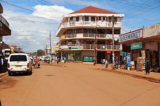
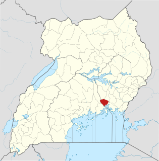
Kamuli District is a district in the Eastern Region of Uganda. The town of Kamuli is the site of the district headquarters.

Mayuge District District in Uganda

Mayuge District is a district in Eastern Uganda. Like many other Ugandan districts, it is named after its 'chief town', Mayuge, where the district headquarters are located.

Pallisa District District in Uganda

Pallisa District is a district in Eastern Uganda. Like most other Ugandan districts, it is named after its chief town, Pallisa, where the district headquarters are located.

Jinja District District in Uganda

Jinja District is a district in the Eastern Region of Uganda. The town of Jinja is the district's main municipal and commercial center.

Buvuma Island is the largest island in the Buvuma Islands chain, in Lake Victoria in Africa.

Amolatar District District in Uganda

Amolatar District is a district in Northern Uganda. Like many other Ugandan districts, it is named after its main municipal and administrative centre, Amolatar Town.

Kiruhura District District in Uganda

Kiruhura District is a district in the Western Region of Uganda. The town of Kiruhura is the site of the district headquarters.

Namutumba District District in Uganda

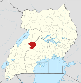
Namutumba District, sometimes referred to as Busiki District is a district in Eastern Uganda. It's named after its 'chief town', Namutumba, where the district headquarters are located.

Buikwe District District in Uganda

Buikwe District is a district in the Central Region of Uganda. It is named after its 'chief town', Buikwe, where the district headquarters are located.

Kyankwanzi District District in Uganda

Kyankwanzi District is the northernmost district in the Buganda Region of Uganda and Buganda Kingdom, bordering Bunyoro. The district headquarters are in Butemba Town.

Buyende District District in Uganda

Buyende District is a district in Eastern Uganda. It is named after Buyende, the 'chief town' in the district and the location of the district headquarters.

Namayingo District District in Uganda

Namayingo District is a district in Eastern Uganda. The district is named after its 'chief town', Namayingo, where the district headquarters are located.

Luuka District District in Uganda

Luuka District is a district in Eastern Uganda.

References

  1. Headquarters of Buvuma District Located At Kitamilo Archived November 26, 2014, at the Wayback Machine
  2. "Approximate Travel Distance Between Jinja And Buvuma With Map". Globefeed.com. Retrieved 14 May 2014.
  3. "Buvuma District: History". Uganda Communications Commission. Archived from the original on 6 March 2016. Retrieved 5 March 2016.
  4. "Estimated Population of Buvuma District In 1991, 2002 & 2012". Citypopulation.de. Retrieved 14 May 2014.
  5. Nangoli, Fred (8 May 2009). "Buvuma the United States of Uganda". New Vision. Archived from the original on 15 May 2014. Retrieved 14 May 2014.
  6. Musingo, Doren (31 August 2011). "Islanders Told To End Relying On Fishing". New Vision. Archived from the original on 15 May 2014. Retrieved 14 May 2014.