Bugiri District is a district in Eastern Uganda. Like most other Ugandan districts, it is named after its 'chief town', Bugiri, where the district headquarters are located.
Iganga District is a district in the Eastern Region of Uganda. The town of Iganga is the site of the district headquarters.

Apac District is a district in the Northern Region of Uganda. The Town of Apac hosts the district headquarters.

Kapchorwa District is a district in the Eastern Region of Uganda. The town of Kapchorwa is the district's main municipal, administrative, and commercial center, and is the site of the district headquarters. It is also the home district of Stephen Kiprotich, the men's marathon gold medalist at the 2012 Summer Olympics, and Joshua Cheptegei, the men's 5,000 m gold medalist at the 2021 Summer Olympics in Tokyo.

Mayuge District is a district in Eastern Uganda. Like many other Ugandan districts, it is named after its 'chief town', Mayuge, where the district headquarters are located.
Pallisa District is a district in Eastern Uganda which was carved out of Tororo district in 1991. Like most other Ugandan districts, it is named after its main town, Pallisa, where the district headquarters are located.

Masindi District is a district in Western Uganda. Like many other Ugandan districts, it is named after its 'chief town' of Masindi, the location of the district headquarters.
Budaka is a town in the Eastern Region of Uganda. It is the chief town of Budaka District, and the district headquarters are located there.

Iganga is a town in the Eastern Region of Uganda. It is the main municipal, administrative, and commercial center of Iganga District.
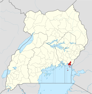
Kaliro is a town in the Eastern Region of Uganda. It is the main municipal, administrative, and commercial center of Kaliro District and the site of the district headquarters.

Dokolo District is a district in the Northern Region of Uganda. The town of Dokolo is its main municipal, administrative, and commercial centre.

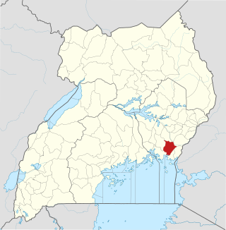
Namutumba District, sometimes referred to as Busiki District is a district in Eastern Uganda. It is named after its 'chief town', Namutumba, where the district headquarters are located.
Namutumba is a town in the Namutumba District of the Eastern Region of Uganda. It is the main municipal, administrative, and commercial centre of the district.
Busembatya, sometimes spelled Busembatia, is a town in the Eastern Region of Uganda.

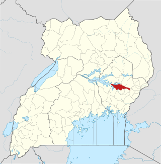
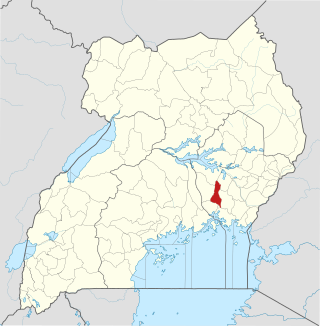
Buyende District is a district in Eastern Uganda. It is named after Buyende, the 'chief town' in the district and the location of the district headquarters.
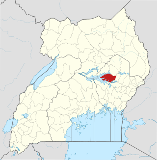
Serere District is a district in Eastern Uganda. It is named after its 'chief town', Serere, which serves as the district headquarters.
Namayingo District is a district in Eastern Uganda. The district is named after its 'chief town', Namayingo, where the district headquarters are located.
Luuka District is a district in Eastern Uganda.
Busoga sub-region is found in Eastern Uganda occupying an area of over 10,000 square kilometers and according to the 2014 national census about 40 percent of the people in the eastern region live in this sub-region.
Iganga–Kaliro–Pallisa Road is a road in the Eastern Region of Uganda, connecting the towns of Iganga in Iganga District to Kaliro in Kaliro District and Pallisa in Pallisa District.

