Masaka District

Last updated
Masaka District, Uganda
Wilaya ya Masaka
Masaka District
Masaka District in Uganda.svg
District location in Uganda
Coordinates: 00°22′S31°42′E / 0.367°S 31.700°E / -0.367; 31.700
Country Uganda
Region Buganda
Capital Masaka
Area
  Land1,295.6 km2 (500.2 sq mi)
Elevation
1,115 m (3,658 ft)
Population
 (2012 Estimate)
  Total251,600
  Density194.2/km2 (503/sq mi)
Time zone UTC+3 (EAT)
Website www.masaka.go.ug

Masaka District is a district in Buganda Kingdom in Uganda. Its main town is Masaka City, [1] whose estimated population in 2011 was 74,100. [2]

Contents

Location

The district is bordered by Masaka City to the north-west and west, Kalungu District to the north, Kalangala District to the east, and Kyotera District to the south-west and south. The town of Masaka, where the district headquarters are located, is approximately 140 kilometres (87 mi) south-west of Kampala on the highway to Mbarara. [3] The coordinates of the district are 00 30S, 31 45E. [4] The average altitude of the district is 1,115 metres (3,658 ft) above sea level. [4]

Overview

Masaka District was established in the 1900s, composed of the Buganda Kingdom's former counties of Buddu, Kooki, Kabula, Mawogola, and Ssese Islands. Kooki and Kabula were peeled off to form Rakai District. Later, the northern part of Rakai District was removed to form Lyantonde District. The Ssese Islands were removed to form Kalangala District. In 1997, Mawogola County was split from Buddu and was named Sembabule District. Buddu remained as Masaka District. In 2010, Buddu itself was split into four districts, namely Masaka District, Bukomansimbi District, Kalungu District, and Lwengo District. In 2020, two sub-counties (Mukungwe and Kabonera) from Masaka District were added to Masaka Municipal Council to form Masaka City.

Administratively, the district council is the highest political authority. The council has 43 members headed by a district chairperson. The technical team at the district is subdivided into the following directories: [5] 1. Education & Sports 2. Health & Environment 3. Works & Technical Services 4. Production & Marketing 5. Finance & Planning 6. Management Support Services 7. Gender & Community Services.

Population

The 1991 national census estimated the district population at 203,600. The 2002 census estimated the population at 228,200, with an annual population growth rate of 1.0 percent. In 2012, the population was estimated at 251,600. [6] From the 2014 population and housing census, the district population was estimated at 297,004. [7] Mid-year population projections by Uganda Bureau of Statistics [8] estimated the district population at 127,600 in 2023.

See also

Related Research Articles

<span class="mw-page-title-main">Buganda</span> Bantu kingdom in central Uganda

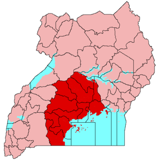
Buganda is a Bantu kingdom within Uganda. The kingdom of the Baganda people, Buganda is the largest of the traditional kingdoms in present-day East Africa, consisting of Uganda's Central Region, including the Ugandan capital Kampala. The 14 million Baganda make up the largest Ugandan region, representing approximately 16% of Uganda's population.

<span class="mw-page-title-main">Ssese Islands</span>

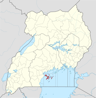
The Ssese Islands are an archipelago of eighty-four islands in the northwestern part of Lake Nalubaale in Uganda. The islands are coterminous with the Kalangala District in southern Central Uganda, which does not have any territory on mainland Uganda.

<span class="mw-page-title-main">Kalangala District</span> District in Central Uganda, Uganda

Kalangala, also known as Ssesse, is a district in Central Uganda. The district is coterminous with the Ssese Islands in Lake Victoria and does not have territory on mainland Uganda. Like other Ugandan districts, it is named after its 'chief town', Kalangala which is located on Bugala Island, the largest of the Ssese Islands.

<span class="mw-page-title-main">Mpigi District</span> District in Central Uganda, Uganda

Mpigi District is a district in Central Uganda. Like most other Ugandan districts, it is named after its 'main town', Mpigi.

<span class="mw-page-title-main">Mukono District</span> District in Central Region of Uganda, Uganda

Mukono is one of the districts in the Central Region of Uganda. The town of Mukono serves as the district headquarters and is home to the district's main commercial center.

<span class="mw-page-title-main">Rakai District</span> District in Central Region of Uganda, Uganda

Rakai District is a district in the Central Region of Uganda. The town of Rakai is the site of the district's headquarters.

<span class="mw-page-title-main">Sembabule District</span> District in Buganda, Uganda

Sembabule District is a district in the Central Region of Uganda. The town of Sembabule is the site of the district headquarters. Other urban centers in the district include Lwemiyaga and Ntuusi.

<span class="mw-page-title-main">Wakiso District</span> District in Central Uganda, Uganda

Wakiso District is a district in the Central Region of Uganda that partly encircles Kampala, Uganda's capital city. The town of Wakiso is the site of the district headquarters. Kira, the country's second largest city and suburb of Kampala, is in the district.

<span class="mw-page-title-main">Masaka</span> Place in Buganda Region, Uganda

Masaka is a district and a city in the Buganda Region in southern Uganda, west of Lake Victoria. The city is the headquarters of Masaka District.

Rakai is a town in the Central Region of Uganda. It is the site of the headquarters of Rakai District. Other towns in the district include Kalisizo, Kyotera Kakuuto and Mutukula.

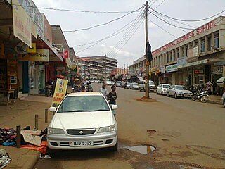
Mpigi is a town in Mawokota County, Mpigi District, in Central Uganda. Mpigi is the municipal, administrative and commercial headquarters of Mpigi District. The district is named after the town.

<span class="mw-page-title-main">Kooki</span> African Kingdom

The Chiefdom of Kooki, also known as the Kooki chiefdom, was a pre-colonial African kingdom located within present-day Rakai District of Uganda that existed from approximately 1740 until 1896. The kingdom ceased to exist as an independent state in 1896 when it merged into the British Protectorate of Buganda. Its royal line still continues to this day as a Chiefdom, and is currently led by The Kamuswaga Apollo Sansa Kabumbuli II a hereditary Saza Chief on behalf of the Kabaka of Buganda. In 27 July 2015, the Kooki Kingdom declared independence from Buganda but it wasn't recognized by Buganda or Uganda.

<span class="mw-page-title-main">Lyantonde District</span> District in Central Uganda, Uganda

Lyantonde District is a district in southern Central Uganda. It is named after the 'chief town' of the district, Lyantonde, where the district headquarters are located.

Kalisizo is a town in the southern part of the Central Region of Uganda. Although it is the leading commercial center in Kyotera District, the administrative headquarters of the district are in Kasaali.

Lukaya is a town in the Kalungu District of the Central Region of Uganda.

Masaka Regional Referral Hospital, commonly known as Masaka Hospital is a hospital in the city of Masaka, in south-central Uganda. It is the referral hospital for the districts of Kalangala District, Lyantonde, Masaka and Sembabule, Kalungu, Lwengo, Bukomansimbi and Rakai.

<span class="mw-page-title-main">Bukomansimbi District</span> District in Central Uganda, Uganda

Bukomansimbi District is a district in Central Uganda. The district is named after its main municipal center, Bukomansimbi, the location of the district headquarters.

<span class="mw-page-title-main">Butambala District</span> District in Central Region, Uganda

Butambala District is a district in the Central Region of Uganda.

Buddu is a county (Ssaza) of the kingdom of Buganda in what is now Uganda.

References

  1. "Tempers flare as Masaka leaders discuss proposed boundaries for". Daily Monitor. Retrieved 2020-08-16.
  2. "Estimated Population of Masaka In 2011" (PDF). Uganda Bureau of Statistics. Archived from the original (PDF) on 7 July 2014. Retrieved 16 April 2014.
  3. "Road Distance Between Kampala And Masaka With Map". Globefeed.com. Retrieved 16 April 2014.
  4. 1 2 "Masaka District |". masaka.go.ug. Retrieved 2020-08-16.
  5. "Overview of Masaka District". Uganda Travel Guide. Retrieved 16 April 2014.
  6. "Estimated Population of Masaka District In 1991, 2002 & 2012". Citypopulation.de. Retrieved 16 April 2014.