Kiryandongo District

Last updated

Kiryandongo District
Kiryandongo high way.jpg
Kiryandongo District in Uganda.svg
District location in Uganda
Coordinates: 02°00′N32°18′E / 2.000°N 32.300°E / 2.000; 32.300
CountryFlag of Uganda.svg  Uganda
Region Western Uganda
Sub-region Bunyoro sub-region
Capital Kiryandongo
Area
  Land3,624.1 km2 (1,399.3 sq mi)
Elevation
1,160 m (3,810 ft)
Population
 (2012 Estimate)
  Total317,500
  Density87.6/km2 (227/sq mi)
Time zone UTC+3 (EAT)
Website www.kiryandongo.go.ug

Kiryandongo District is a district in Western Uganda. Like many other Ugandan districts, it is named after its 'chief town', Kiryandongo, where the district headquarters are located.

Contents

Location

Sunset on Karuma area Sunset view of Karuma area.jpg
Sunset on Karuma area

Kiryandongo District is bordered by Nwoya District to the north, Oyam District to the northeast, Apac District to the east, and Masindi District to the south and west. Kiryandongo, the location of the district headquarters, lies approximately 225 kilometres (140 mi) northwest of Kampala, Uganda's capital and largest city. [1] The coordinates of the district are:02 00N, 32 18E (Latitude:2.0000; Longitude:32.3000).

Overview

Kiryandongo District was established on 1 July 2010. It was previously part of Masindi District. The district is part of Bunyoro sub-region, which is coterminous with Bunyoro Kingdom. The districts that constitute Bunyoro sub-region include the following: 1. Buliisa District 2. Hoima District 3. Kibaale District 4. Kiryandongo District and 5. Masindi District. In 2002, the sub-region was home to an estimated 750,000 inhabitants, according to the national population and household census conducted that year.

Population

The 1991 Uganda national census estimated the district population at 83,405. According to the 2002 national census, that population had increased to about 187,700. In 2012, the population of Kiryandongo District was estimated at 317,500. [2] A new national census is planned for August 2014. [3]

See also

Related Research Articles

<span class="mw-page-title-main">Hoima District</span> District in Western Uganda, Uganda

Hoima District is a district in Western Uganda. Like most other Ugandan districts, it is named after its main municipal centre, Hoima.

<span class="mw-page-title-main">Kibaale District</span> District in Western Region, Uganda

Kibaale District, is a district in the Western Region of Uganda. The district headquarters are in the town of Kibaale.

<span class="mw-page-title-main">Masindi District</span> District in Western Uganda, Uganda

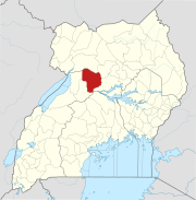
Masindi District is a district in Western Uganda. Like many other Ugandan districts, it is named after its 'chief town' of Masindi, the location of the district headquarters.

<span class="mw-page-title-main">Masindi</span> Place in Western Region of Uganda, Uganda

Masindi is a town in the Western Region of Uganda. It is on the road between Kampala and the Murchison Falls National Park. It is the site of the headquarters of the Masindi District.

<span class="mw-page-title-main">Murchison Falls National Park</span> National park in Western Region, Uganda

Murchison Falls National Park (MFNP) is a national park in Uganda managed by the Ugandan Wildlife Authority. Located in north-western Uganda, it spreads inland from the shores of Lake Albert, around the Victoria Nile, up to the Karuma Falls.

Hoima is a city in the Western Region of Uganda. It is the main municipal, administrative, and commercial center of Hoima District. It is also the location of the palace of the Omukama of Bunyoro.

Luweero is a town in the Central Region of Uganda. It is the main municipal, administrative, and commercial center of Luweero District.

<span class="mw-page-title-main">Buliisa District</span> Ugandan administrative district

Buliisa District is a district in Western Uganda. As with most Ugandan districts, Buliisa District is named after its "main town" Buliisa, where the district headquarters are located. Bugungu has 6 sub counties: Kigwera, Ngwedo, Buliisa, Butiaba, Kihungya, and Biiso. It also contain 3 town councils: Buliisa, Butiaba and Biiso.

Hoima Regional Referral Hospital, commonly known as Hoima Hospital, is a hospital in the city of Hoima in Hoima District in the Western Region of Uganda. It is the referral hospital for the districts of Bulisa, Hoima, Kibaale, Kiryandongo, Kagadi, Kakumiro, Kikuube, and Masindi.

Kigumba is a town in Kiryandongo District, northwestern Uganda. It is one of the urban centers in the district. The other urban centres in Kiryandongo District include: (a) Karuma b) Kiryandongo (c) Bweyale and (d) Masindi Port.

<span class="mw-page-title-main">Masindi Port</span> Ugandan town

Masindi Port is a town in the Western Region of Uganda. The name also applied to the sub-county, where the own sits and forms the sub-county headquarters.

Butiaba, is a town in the Western Region of Uganda. It is a fishing town and landing site on the shores of Lake Albert, in Uganda.

<span class="mw-page-title-main">Kyankwanzi District</span> District in Buganda Region, Uganda

Kyankwanzi District is the westernmost district in the Buganda Region of Uganda and Buganda Kingdom, bordering Bunyoro. The district headquarters are in Butemba Town.

<span class="mw-page-title-main">Nwoya District</span> District in Northern Uganda, Uganda

Nwoya District is a district in Northern Uganda. Like most districts in Uganda, it is named after its main municipal, administrative and commercial center, Nwoya, the location of the district headquarters.

Kiryandongo is a town in the Western Region of Uganda. It is the main municipal, administrative, and commercial center of Kiryandongo District.

<span class="mw-page-title-main">Ntoroko District</span> District in Western Region, Uganda

Ntoroko District is a district in the Western Region of Uganda. The district headquarters are in the Kibbuuku town council. It is the second least populated district in Uganda.

<span class="mw-page-title-main">Bunyoro sub-region</span>

Bunyoro sub-region is a region in Western Uganda that consists of the following districts:

Rwekunye is a settlement in Kiryandongo District in the Western Region of Uganda.

Kiryandongo General Hospital, is a hospital in the Western Region of Uganda.

<span class="mw-page-title-main">Kikuube District</span> Ugandan administrative district

Kikuube District is a district in the Western Region of Uganda. It is named after its main municipal centre, Kikuube.

References

  1. "Map Showing Kampala And Kiryandongo With Distance Marker". Globefeed.com. Retrieved 15 April 2014.
  2. "Estimated Population of Kiryandongo District In 2002, 2010 & 2012". Citypopulation.de. Retrieved 8 May 2014.
  3. Baguma, Raymond (12 September 2013). "National Population Census for 2014". New Vision . Retrieved 8 May 2014.