Namayingo District

Last updated

Namayingo District
Namayingo District in Uganda.svg
District location in Uganda
Coordinates: 00°17′N33°51′E / 0.283°N 33.850°E / 0.283; 33.850
CountryFlag of Uganda.svg  Uganda
Region Eastern Uganda
Sub-region Busoga sub-region
Capital Namayingo
Area
  Land532.9 km2 (205.8 sq mi)
Elevation
1,200 m (3,900 ft)
Population
 (2012 Estimate)
  Total232,300
  Density435.9/km2 (1,129/sq mi)
Time zone UTC+3 (EAT)
Website www.namayingo.go.ug

Namayingo District is a district in Eastern Uganda. The district is named after its 'chief town', Namayingo, where the district headquarters are located.

Contents

Location

Namayingo District is located along the Equator. It is bordered by Bugiri District to the northwest, Busia District to the northeast, the Republic of Kenya to the east and southeast, the Republic of Tanzania to the south and Mayuge District to the west and southwest. Namayingo, where the district headquarters are located, is approximately 95 kilometres (59 mi), by road, southeast of Jinja, the largest city in the Busoga sub-region. [1] This location lies approximately 38 kilometres (24 mi), by road, south of Bugiri, the nearest large town. [2] The coordinates of the district are:00 17N, 33 51E.

Overview

The district was established by an Act of Parliament and began functioning on 1 July 2010. Prior to that it was part of Bugiri District. Namayingo District is part of Busoga sub-region. Other districts in Busoga include:

1. Buyende District

2. Iganga District

3. Jinja District

4. Kaliro District

5. Kamuli District

6. Luuka District

7. Mayuge District

8. Namutumba District.

Prior to 2000, the two main activities in the district were (a) subsistence agriculture on the mainland and (b) commercial fishing on the lakeshores and on the islands in Lake Victoria. During the 21st century, gold deposits have been discovered in the district. This has attracted many new residents to the area, performing such activities as: miners, washers, grinders, middlemen, buyers as well as salesmen of the hardware used in the artisanal gold mining industry, such as pick axes, shovels, pails, basins, ropes and ladders. [3]

Population

The 1991 national population census estimated the district population at about 68,000. In 2002, the next national census put the population of the district at approximately 175,000. The district annual population growth rate was calculated at 2.9%. It is estimated that the population of Namayingo District was approximately 232,300 in 2012. [4]

See also

Related Research Articles

<span class="mw-page-title-main">Bugiri District</span> District in Eastern Uganda, Uganda

Bugiri District is a district in Eastern Uganda. Like most other Ugandan districts, it is named after its 'chief town', Bugiri, where the district headquarters are located.

<span class="mw-page-title-main">Iganga District</span> District in Eastern Uganda, Uganda

Iganga District is a district in the Eastern Region of Uganda. The town of Iganga is the site of the district headquarters.

<span class="mw-page-title-main">Mayuge District</span> District in Eastern Uganda, Uganda

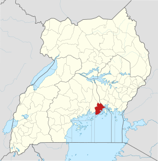
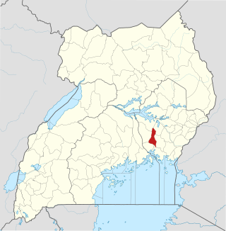
Mayuge District is a district in Eastern Uganda. Like many other Ugandan districts, it is named after its 'chief town', Mayuge, where the district headquarters are located.

<span class="mw-page-title-main">Jinja District</span> District in Eastern Region, Uganda

Jinja District is a district in the Eastern Region of Uganda. The town of Jinja is the district's main municipal and commercial center.

Bugiri is a town in the Eastern Region of Uganda. It is the chief town of Bugiri District, and the district headquarters are located there. The town was elevated to Municipal Council status in 2019.

<span class="mw-page-title-main">Iganga</span> Ugandan town

Iganga is a town in the Eastern Region of Uganda. It is the main municipal, administrative, and commercial center of Iganga District.

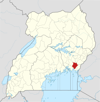
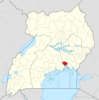
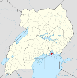
Mayuge is a town in the Eastern Region of Uganda. It is the location of the headquarters of Mayuge District.

<span class="mw-page-title-main">Kaliro District</span> District in Eastern Region of Uganda, Uganda

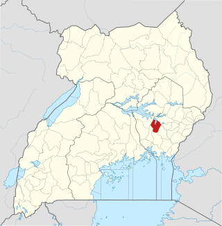
Kaliro District is a district in the Eastern Region of Uganda. It was created out of the eastern part of Kamuli District in 2006. Kaliro is the site of the district headquarters.

Bugembe is a town in Jinja District in the Eastern Region of Uganda. It is the seat of the Kingdom of Busoga, one of the four constitutional in Uganda, which is coterminous with the Busoga sub-region.

<span class="mw-page-title-main">Namutumba District</span> District in Eastern Uganda, Uganda

Namutumba District, sometimes referred to as Busiki District is a district in Eastern Uganda. It is named after its 'chief town', Namutumba, where the district headquarters are located.

<span class="mw-page-title-main">Buikwe District</span> District in Central Uganda, Uganda

Buikwe District is a district in the Central Region of Uganda. It is named after its 'chief town', Buikwe, where the district headquarters are located.

<span class="mw-page-title-main">Buvuma District</span> District in Central Uganda, Uganda

Buvuma District is a district in the Central Region of Uganda. The district is coterminous with the Buvuma Islands archipelago in Lake Victoria and does not have territory on mainland Uganda.

<span class="mw-page-title-main">Buyende District</span> District in Eastern Uganda, Uganda

Buyende District is a district in Eastern Uganda. It is named after Buyende, the 'chief town' in the district and the location of the district headquarters.

<span class="mw-page-title-main">Luuka District</span> District in Eastern Uganda, Uganda

Luuka District is a district in Eastern Uganda.

Namayingo is a town in Namayingo District in the Eastern Region of Uganda. It is the site of the district headquarters.

Mayuge Sugar Industries Limited (MSIL) is a sugar manufacturer in Uganda, the third-largest economy in the East African Community.

The Musita–Mayuge–Lumino–Majanji–Busia Road is a road in the Eastern Region of Uganda, connecting the town of Musita in Mayuge District to Busia in Busia District at the international border with Kenya.

Musita is a town in Mayuge District, in the Eastern Region of Uganda.

Lumino is a settlement in the Eastern Region of Uganda.

The Jinja–Iganga–Bugiri–Tororo Road is a road in the Eastern Region of Uganda, connecting the towns of Jinja and Tororo. Sometimes referred to as Tororo–Jinja Road, it is a busy transport corridor, connecting traffic from neighboring Kenya, and northeastern Uganda to Jinja, a major commercial and industrial center, and ultimately to Kampala, the country's capital and points beyond.

References

  1. "Distance Between Namayingo And Jinja With Map". Globefeed.com. Retrieved 9 April 2014.
  2. "Map Showing Bugiri And Namayingo With Distance Marker". Globefeed.com. Retrieved 9 April 2014.
  3. Wacha, Joe (12 October 2012). "Gold Attracts Uganda's Tribes To Namayingo District". Uganda Radio Network Online. Retrieved 8 April 2014.
  4. "Estimated Population of Namayingo District In 1991, 2002 & 2012". Citypopulation.de. Retrieved 20 May 2014.