Amolatar District

Last updated
Amolatar District
Amolatar District in Uganda.svg
District location in Uganda
Coordinates: 01°38′N32°50′E / 1.633°N 32.833°E / 1.633; 32.833
CountryFlag of Uganda.svg  Uganda
Region Northern Uganda
Sub-region Lango sub-region
Capital Amolatar
Area
  Total1,758 km2 (679 sq mi)
Population
 (2010 Estimate)
  Total127,400
  Density72.5/km2 (188/sq mi)
Time zone UTC+3 (EAT)
Website www.amolatar.go.ug

Amolatar District is a district in Northern Uganda. Like many other Ugandan districts, it is named after its main municipal and administrative centre, Amolatar Town.

Contents

Location

Amolatar District is bordered by Apac District to the north, Dokolo District to the northeast, Kaberamaido District to the east, Buyende District to the southeast, Kayunga District to the south and Nakasongola District to the west. The administrative headquarters of the district at Amolatar, are located 85 kilometres (53 mi), by road, south of Lira, the largest city in the sub-region. [1] This location lies about 185 kilometres (115 mi), by road, northeast of Kampala, the capital of Uganda and the largest city in that country. [2] The coordinates of the district are:01 38N, 32 50E.

Overview

Amolatar District was formed in 2005, when it was carved out of Lira District. The district is part of the Lango sub-region, together with the other seven districts listed below. The constituent districts of the Lango sub-region are:

  1. Amolatar District
  2. Alebtong District
  3. Apac District
  4. Dokolo District
  5. Kole District
  6. Lira District
  7. Oyam District
  8. Otuke District

The district contains 346 villages, organized into 33 parishes. The district covers an area of approximately 1,758 square kilometres (679 sq mi). Administratively, the district is divided into the five administrative units:

  1. Amolatar Town Council
  2. Muntu Sub-county: 426.16 square kilometres (164.54 sq mi)
  3. Awelo Sub-county, Etam Town Council, Namasale Town Council 377.20 square kilometres (145.64 sq mi)
  4. Namasale Sub-county 524.18 square kilometres (202.39 sq mi)
  5. Aputi Sub-county 254.23 square kilometres (98.16 sq mi).

The district is known for the Amolatar Monument which marks the geographic centre of Uganda.

The Amolatar Monument Amolatar Uganda Tribes Monument (Uganda Geographical Centre)-2.jpg
The Amolatar Monument

Population

The 1991 national census estimated the district population at about 68,500. The 2002 national census estimated the population of the district at approximately 96,200. The district population is growing at an estimated annual rate of 2.9%, between 2002 and 2012. It is estimated that the population of the district in 2012 was about 127,400. [3]

Economic activities

Subsistence agriculture, animal husbandry and commercial fishing from area lakes constitute the economic engine of the district. Crops grown include:

Livestock raised in the district includes: cattle, goats, chicken and turkeys.

See also

Related Research Articles

<span class="mw-page-title-main">Nakasongola District</span> District in Central Region of Uganda, Uganda

Nakasongola District is the northernmost district of the Central Region of Uganda. The town of Nakasongola is the site of the district's administrative headquarters.

<span class="mw-page-title-main">Kaberamaido District</span> District in Eastern Uganda, Uganda

Kaberamaido is a district in Eastern Uganda. Like most other Ugandan districts, it is named after its 'chief town', Kaberamaido, where the district headquarters are located.

<span class="mw-page-title-main">Apac District</span> District in Northern Region, Uganda

Apac District is a district in the Northern Region of Uganda. The Town of Apac hosts the district headquarters.

<span class="mw-page-title-main">Lira District</span> District in Northern Uganda, Uganda

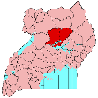
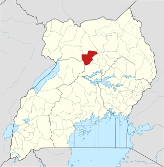
Lira District is a district in Northern Uganda. Like many other Ugandan districts, it is named after its 'chief town', Lira.

<span class="mw-page-title-main">Apac</span> Ugandan town

Apac is a town in Apac District in the Northern Region of Uganda. It is the 'chief town' of the district and the district headquarters are located there. The district is named after the town.

<span class="mw-page-title-main">Lango sub-region</span>

Lango sub-region is a region in Uganda covering an area of 15,570.7km consisting of the districts of:

Ibanda is a town in the Western Region of Uganda. It is the main political, administrative, and commercial centre of Ibanda District and the site of the district headquarters. It started wayback in 1990s and was elevated from a trading centre to a town board, town council and in 2016 it was granted a Municipality status. The Municipal Council has three Divisions of Kagongo, Bisheshe and Bufunda with 21 wards of Kyaruhanga, Bufunda, Nyamirima, Nsasi, Kayenje, Kashangura, Rwenshuri, Kigarama, Rugazi, Rwobuzizi, Kakatsi, Bugarama, Karangara, Kabaare, Kanyansheko, Nyakatookye, Kyeikucu, Kikoni, Kagongo, Ruyonza and Katongore ward. Ibanda Municipal Council has over 230 villages. Ibanda Municipal council commenced its operations on 1 July 2016 after being elevated from a Town Council and other sub counties that were annexed to..

Amolatar is a town in Northern Uganda. It is the main municipal, administrative and commercial centre of Amolatar District. The district is named after the town.

<span class="mw-page-title-main">Dokolo District</span> District in Northern Region, Uganda

Dokolo District is a district in the Northern Region of Uganda. The town of Dokolo is its main municipal, administrative, and commercial centre.

Dokolo is a town in the Northern Region of Uganda. It is the main municipal, administrative, and commercial centre of Dokolo District.

<span class="mw-page-title-main">Oyam District</span> District in Northern Uganda, Uganda

Oyam District is a district in Northern Uganda. Like most Ugandan districts, it is named after its 'chief town', Oyam, where the district headquarters are located.

<span class="mw-page-title-main">Abim District</span> District in Uganda

Abim District is a district in Northern Uganda. It is named after its 'chief town', Abim, where the district headquarters are located.

Aduku is a town in, Kwania District following the curving out of Kwania from Apac District in northern Uganda. It Head Quarter location of Kwania District.

<span class="mw-page-title-main">Otuke District</span> District in Uganda

Otuke District is a district in Northern Uganda. Like many other Ugandan districts, Otuke district is named after its 'chief town', Otuke, where the district headquarters are located.

<span class="mw-page-title-main">Kole District</span> District in Northern Uganda, Uganda

Kole District is a district in Northern Uganda. Like most other Ugandan districts, it is named after its 'chief town', Kole, where the district headquarters are located.

Kole is a town in Northern Uganda. It is the main municipal, administrative and commercial center of Kole District. The district is named after the town.

<span class="mw-page-title-main">Alebtong District</span> District in Northern Region of Uganda, Uganda

Alebtong District is a district in the Northern Region of Uganda. The town of Alebtong serves as the district headquarters.

Alebtong, is a town in the Northern Region of Uganda. It is the chief municipal, administrative, and commercial centre of Alebtong District. The district is named after the town.

Rwekunye is a settlement in Kiryandongo District in the Western Region of Uganda.

The Soroti–Dokolo–Lira Road is a road in Uganda, connecting the towns of Soroti in Soroti District, Dokolo in Dokolo District, and Lira in Lira District.

References

  1. "Road Distance Between Lira And Amolatar With Map". Globefeed.com. Retrieved 24 May 2014.
  2. "Map Showing Kampala And Amolatar With Distance Marker". Globefeed.com. Retrieved 24 May 2014.
  3. "Estimated Population of Amolatar District In 1991, 2002 & 2012". Citypopulation.de. Retrieved 24 May 2014.