Nwoya District

Last updated

Nwoya District
Nwoya District in Uganda.svg
District location in Uganda
Coordinates: 02°38′N32°00′E / 2.633°N 32.000°E / 2.633; 32.000
CountryFlag of Uganda.svg  Uganda
Region Northern Uganda
Sub-region Acholi sub-region
Capital Nwoya
Area
  Total4,736.2 km2 (1,828.7 sq mi)
Population
 (2012 Estimate)
  Total54,000
  Density11.4/km2 (30/sq mi)
Time zone UTC+3 (EAT)
Website www.nwoya.go.ug

Nwoya District is a district in Northern Uganda. Like most districts in Uganda, it is named after its main municipal, administrative and commercial center, Nwoya, the location of the district headquarters.

Contents

Location

Nwoya District is bordered by Amuru District to the north, Gulu District to the north-east, Oyam District to the east, Kiryandongo District to the south-east, Masindi District to the south, and Buliisa District to the south-west. Nwoya, the main political, administrative and commercial center in the district, is approximately 44 kilometres (27 mi) south-west of the city of Gulu, the largest metropolitan area in the sub-region. [1] This location is approximately 330 kilometres (210 mi), by road, north of the city of Kampala, Uganda's capital and largest metropolitan area. [2]

Overview

Nwoya District is one of the newest districts in Uganda. It was established by an Act of Parliament and began functioning on 1 July 2010. Prior to that date, it was part of Amuru District. The district is part of the Acholi sub-region.

Population

In 1991, the district population was estimated at 37,900. In 2002, the population was recorded at 41,010. In 2012, the mid-year population was estimated at 54,000. [3]

Economic activity

Prior to 2013, subsistence agriculture and livestock husbandry were the main economic activity in the district. More recently, crude oil deposits have been found and commercial extraction is being planned. [4] [5]

See also

Related Research Articles

<span class="mw-page-title-main">Gulu District</span> Neucleated District in Northern Region of Uganda, Uganda

Gulu is a district in the Northern Region of Uganda. The regional headquarters are located in the city of Gulu, which is also the administrative capital of Northern Uganda. the district consists of two main divisions, Gulu West and Gulu East.

<span class="mw-page-title-main">Kitgum District</span> District in Northern Uganda, Uganda

Kitgum District is a district in Northern Uganda. It is named after its major town of Kitgum, where the district headquarters is located. It has suffered much fatalities and social disruption resulting from the 20-year civil war in the region during the late 20th century. The government moved tens of thousands of residents to internally displaced persons camps for their protection, where they were subject to raids by the rebels and also harsh conditions, including disease.

<span class="mw-page-title-main">Pader District</span> District in Northern Uganda, Uganda

Pader District is a district in Northern Uganda. It is named after Pader, the chief municipal, administrative and commercial town in the district, where the district headquarters are located.

<span class="mw-page-title-main">Murchison Falls National Park</span> National park in Western Region, Uganda

Murchison Falls National Park (MFNP) is a national park in Uganda managed by the Ugandan Wildlife Authority. Located in north-western Uganda, it spreads inland from the shores of Lake Albert, around the Victoria Nile, up to the Karuma Falls.

Atiak is a town in the Northern Region of Uganda on the Gulu-Nimule Road, the primary trade route between Uganda and South Sudan.

<span class="mw-page-title-main">Oyam District</span> District in Northern Uganda, Uganda

Oyam District is a district in Northern Uganda. Like most Ugandan districts, it is named after its 'chief town', Oyam, where the district headquarters are located.

<span class="mw-page-title-main">Amuru District</span> District in Northern Uganda, Uganda

Amuru District is a district in Northern Uganda. Like most Ugandan districts, it is named after its 'chief town', Amuru, where the district headquarters are located.

<span class="mw-page-title-main">Pabbo</span> Municipality in Northern Region of Uganda, Uganda

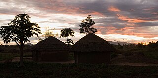
Pabbo, sometimes spelled as Pabo, is a municipality in Amuru District of the Northern Region of Uganda.

Anaka is a town in the Northern Region of Uganda. It is the site of the Nwoya District headquarters.

Gulu–Nimule Road is a road in the Northern Region of Uganda, connecting the city of Gulu in Gulu District and the town of Nimule in Eastern Equatoria State in South Sudan, just north of the international border between the two countries. The road, known as Highway A104 in Uganda, continues into South Sudan as Highway A43.

Nwoya is a town in Nwoya District in the Acholi sub-region, in the Northern Region of Uganda. It is the main municipal, administrative, and commercial centre of the district. Nwoya Town Council is classified as a municipality.

<span class="mw-page-title-main">Lamwo District</span> District in Northern Region of Uganda, Uganda

Lamwo District is a district in the Northern Region of Uganda. The town of Lamwo is the site of the district headquarters.

<span class="mw-page-title-main">Zombo District</span> District in Northern Uganda, Uganda

Zombo District is a district in the Northern Region of Uganda. The town of Zombo is the district's main municipal, administrative, and commercial center,

<span class="mw-page-title-main">Agago District</span> District in Northern Uganda, Uganda

The Agago District is a Ugandan district located in the Northern Region of Uganda.

Bibia is a municipality in the Amuru District of the Northern Region of Uganda.

Amuru is a town in the Northern Region of Uganda. It is the main municipal, administrative, and commercial centre of Amuru District.

Elegu is a town in the Northern Region of Uganda. It sits across the international border from the town of Nimule, South Sudan.

Amuru Sugar Works Limited (ASWL) is a proposed sugar manufacturing company in the Northern Region of Uganda.

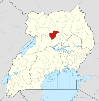
Omoro District is a district in the Northern Region of Uganda.

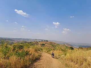
Koch-Goma, also Koch Goma, is a human settlement in Nwoya District, in the Northern Region of Uganda.

References

  1. "Road Distance Between Gulu And Nwoya With Map". Globefeed.com. Retrieved 22 May 2014.
  2. "Map Showing Kampala And Nwoya With Distance Marker". Globefeed.com. Retrieved 22 May 2014.
  3. "Estimated Population of Nwoya District In 1991, 2002 & 2012". Citypopulation.de. Retrieved 22 May 2014.
  4. "Total Discovers Oil In Uganda's Nwoya District". Oil Review Africa. 21 January 2013. Retrieved 22 May 2014.[ permanent dead link ]
  5. Imaka, Isaac (2 June 2014). "Oil Finding Fuels Clashes". Daily Monitor . Retrieved 2 June 2014.