Kaberamaido District

Last updated
Kaberamaido District
Kaberamaido District in Uganda.svg
District location in Uganda
Coordinates: 01°47′N33°09′E / 1.783°N 33.150°E / 1.783; 33.150
CountryFlag of Uganda.svg  Uganda
Region Eastern Uganda
Sub-region Teso sub-region
Capital Kaberamaido
Area
  Total1,788.5 km2 (690.5 sq mi)
  Land1,354.5 km2 (523.0 sq mi)
  Water434 km2 (168 sq mi)
Elevation
1,080 m (3,540 ft)
Population
 (2012 Estimate)
  Total199,200
  Density147.1/km2 (381/sq mi)
Time zone UTC+3 (EAT)
Website www.kaberamaido.go.ug

Kaberamaido is a district in Eastern Uganda. Like most other Ugandan districts, it is named after its 'chief town', Kaberamaido, where the district headquarters are located.

Contents

Location

Kaberamaido District lies approximately between Latitudes:1.5500 to 2.3834 and Longitudes:30.0167 to 34.3000. The average coordinates of the district are:01 47N, 33 09E. The district is bordered by Alebtong District to the north, Amuria District to the northeast, Soroti District to the east, Serere District to the southeast, Buyende District to the south, Amolatar District to the southwest and Dokolo District to the northwest. [1] The District headquarters at Kaberamaido lies approximately 65 kilometres (40 mi) by road, west of Soroti, the largest city in the sub-region. [2] It lies approximately 215 kilometres (134 mi), by road, northeast of Kampala, the capital of Uganda and the nation's largest city. [3]

Physical measurements

The following are the district measurements:

Population

In 1991, the national population census estimated the population of the district at about 81,500. The district had a population of approximately 131,700 in 2002, according to the national census that year, with an annual population growth rate of 4.3%. In 2012, it was estimated that the population of Kaberamaido District was approximately 199,200. [4] The table below, illustrates how the district has grown between 2002 and 2012. All numbers are estimates.

Kaberamaido District Population Trends
YearEst. Pop.
2002131,700
2003137,200
2004143,000
2005149,000
YearEst. Pop.
2006155,300
2007161,800
2008168,600
2009175,700
YearEst. Pop.
2010183,100
2011190,800

Ethnicities

Kaberamaido District is the main area of the Kumam people. In 2008, the Kumam were in the majority, totaling 99,738 (74.7%) of the population. The Iteso were the next most populous group in the district, totaling 27,317 people (20.5%). These two ethnicities respectively, speak Kumam and Ateso languages and are of the Nilotic family. The Langi at 4,617 people (3.5%) are the next most populous group. The other tribal groups found in the district constitute less than 1% of the district population in individual tribal terms. These include, the Acholi, Bagwere, Bakenyi, Baruli, Mening, Basoga, Baganda and Alur.

See also

Related Research Articles

<span class="mw-page-title-main">Kayunga District</span> District in Central Uganda, Uganda

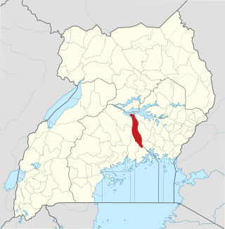
Kayunga District is a district in Central Uganda. It is named after its chief town, Kayunga.

<span class="mw-page-title-main">Wakiso District</span> District in Central Uganda, Uganda

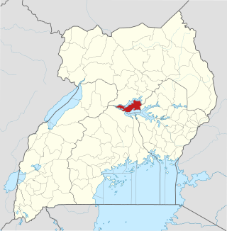
Wakiso District is a district in the Central Region of Uganda that partly encircles Kampala, Uganda's capital city. The town of Wakiso is the site of the district headquarters. Kira, the country's second largest city and suburb of Kampala, is in the district.

<span class="mw-page-title-main">Katakwi District</span> District in Eastern Uganda, Uganda

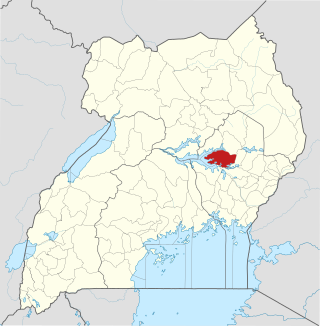
Katakwi District is a district in the Eastern Region of Uganda. The town of Katakwi is the site of the district headquarters.

<span class="mw-page-title-main">Soroti District</span> District in Eastern Uganda, Uganda

Soroti District is a district in Eastern Uganda. It is named after its chief municipal, administrative and commercial headquarters, Soroti, where the district headquarters are located.

<span class="mw-page-title-main">Soroti</span> Ugandan town

Soroti is a city in Eastern Region of Uganda. It is the main city, commercial, and administrative center in Soroti District, one of the nine administrative districts in the Teso sub-region. Soroti city was immediately approved for operationalization ahead of schedule by the Parliament of Uganda in the Financial Year 2020/2021.

<span class="mw-page-title-main">Moroto Town</span> Place in Northern Region, Uganda

Moroto is a town in Moroto District in the Northern Region of Uganda. The town serves as the location of the district headquarters.

Katakwi is a town in the Eastern Region of Uganda. It is the main municipal, administrative, and commercial center of Katakwi District and the site of the district headquarters.

Kaberamaido is a town in Eastern Uganda. It is the main municipal, administrative and commercial center of Kaberamaido District and is the location of the headquarters for the district.

Amuria is a town in the Eastern Region of Uganda. It is the chief municipal, administrative, and commercial center of Amuria District, in the Teso sub-region.

<span class="mw-page-title-main">Amuria District</span> District in Eastern Uganda, Uganda

Amuria District is a district in the Eastern Region of Uganda. The town of Amuria serves as the district headquarters.

<span class="mw-page-title-main">Amolatar District</span> District in Northern Uganda, Uganda

Amolatar District is a district in Northern Uganda. Like many other Ugandan districts, it is named after its main municipal and administrative centre, Amolatar Town.

Kumi Town, commonly called Kumi, is a town in the Eastern Region of Uganda. It is the main municipal, administrative, and commercial center in Kumi District and is the site of the district headquarters.

Dokolo is a town in the Northern Region of Uganda. It is the main municipal, administrative, and commercial centre of Dokolo District.

Bukedea is a town in the Eastern Region of Uganda. It is the chief municipal, administrative, and commercial center of Bukedea District, and the district headquarters are located there.

<span class="mw-page-title-main">Abim District</span> District in Uganda

Abim District is a district in Northern Uganda. It is named after its 'chief town', Abim, where the district headquarters are located.

Abim is a town in the Northern Region of Uganda. It is the chief municipal, administrative, and commercial center of Abim District. The district is named after the town.

<span class="mw-page-title-main">Buyende District</span> District in Eastern Uganda, Uganda

Buyende District is a district in Eastern Uganda. It is named after Buyende, the 'chief town' in the district and the location of the district headquarters.

<span class="mw-page-title-main">Serere District</span> District in Uganda

Serere District is a district in Eastern Uganda. It is named after its 'chief town', Serere, where the district headquarters are located.

<span class="mw-page-title-main">Ngora District</span> District in Eastern Region of Uganda, Uganda

Ngora District is a district in the Eastern Region of Uganda. The town of Ngora is the site of the district headquarters.

<span class="mw-page-title-main">Amudat District</span> District in Northern Uganda, Uganda

Amudat District is a district in Northern Uganda. Like most Ugandan districts, it is named after its 'chief town', Amudat, where the district headquarters are located.

References

  1. Uganda District Map
  2. "Map Showing Soroti And Kaberamaido With Distance Marker". Globefeed.com. Retrieved 18 May 2014.
  3. "Distance Between Kampala And Kaberamaido With Map". Citypopulation.de. Retrieved 18 May 2014.
  4. "Estimated Population of Kaberamaido District In 1991, 2002 & 2012". Citypopulation.de. Retrieved 18 May 2014.