Mbale District is a district in Eastern Uganda. It is named after the largest city in the district, Mbale, which also serves as the main administrative and commercial center in the sub-region.

Mubende is a district in the Central Region of Uganda. The town of Mubende is the site of the district headquarters. The district was reduced in size in July 2005 with the creation of the Mityana District and reduced again in 2019 when Kassanda District was carved out of it.

Sembabule District is a district in the Central Region of Uganda. The town of Sembabule is the site of the district headquarters. Other urban centers in the district include Lwemiyaga and Ntuusi.

Kaberamaido is a district in Eastern Uganda. Like most other Ugandan districts, it is named after its 'chief town', Kaberamaido, where the district headquarters are located.

Apac District is a district in the Northern Region of Uganda. The Town of Apac hosts the district headquarters.

Hoima District is a district in Western Uganda. Like most other Ugandan districts, it is named after its main municipal centre, Hoima.
Kamwenge District is a district in Western Uganda. It is named after its 'chief town', Kamwenge, where the district headquarters are located. Kamwenge District is part of the Kingdom of Toro, one of the ancient traditional monarchies in Uganda. The kingdom is coterminous with Toro sub-region. The districts that constitute the sub-region are: (a) Bunyangabu District (b) Kabarole District (c) Kamwenge District (d) Kyegegwa District (e) Kitagwenda District and (f) Kyenjojo District.

Masindi District is a district in Western Uganda. Like many other Ugandan districts, it is named after its 'chief town' of Masindi, the location of the district headquarters.

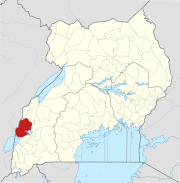
Kasese is a town in the Western Region of Uganda. It is the capital of Kasese District. Kasese is also the largest town in the Rwenzururu region. In 2020 it had an estimated population 115,400. It lies north of Lake George and east of Rwenzori Mountains.
Amolatar District is a district in Northern Uganda. Like many other Ugandan districts, it is named after its main municipal and administrative centre, Amolatar Town.
Mpondwe is a town in the Western Region of Uganda.
Rwimi is a town in Bunyangabu District in the Western Region of Uganda. With an estimated population of 16,200 in 2020 it is the largest urban center in the district, but the district headquarters are located elsewhere; in Kibiito.

Abim District is a district in Northern Uganda. It is named after its 'chief town', Abim, where the district headquarters are located.
Hima is a town in the Western Region of Uganda. It is an industrial town, involved primarily in the manufacture of cement.
Mweya is a location in the Western Region of Uganda.

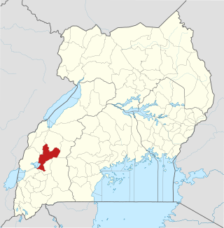
Rubirizi District is a district in Western Uganda. Like most Ugandan districts, the district is named after its 'chief town', Rubirizi, where the district headquarters are located.

Ntoroko District is a district in the Western Region of Uganda. The district headquarters are in the Kibbuuku town council. It is the second least populated district in Uganda.
Katunguru, is a settlement in Rubirizi District, Ankole sub-region, in the Western Region of Uganda. The name also applies to Katunguru Sub-county and Katunguru Parish, where the settlement is located.
Bugoye is a small town in Western Uganda.
Kitagwenda District is a district in Western Uganda. The district is named after Kitagwenda County, which is coterminous with the district.