Kitgum District

Last updated
Kitgum District
Kitgum District in Uganda.svg
District location in Uganda
Coordinates: 03°13′N32°47′E / 3.217°N 32.783°E / 3.217; 32.783
CountryFlag of Uganda.svg  Uganda
Region Northern Uganda
Sub-region Acholi sub-region
Capital Kitgum
Area
  Total3,960 km2 (1,530 sq mi)
Population
 (2012 Estimate)
  Total247,800
  Density62.6/km2 (162/sq mi)
Time zone UTC+3 (EAT)
Website www.kitgum.go.ug

Kitgum District is a district in Northern Uganda. It is named after its major town of Kitgum, where the district headquarters is located. It has suffered much fatalities and social disruption resulting from the 20-year civil war in the region during the late 20th century. The government moved tens of thousands of residents to internally displaced persons camps for their protection, where they were subject to raids by the rebels and also harsh conditions, including disease.

Contents

Location

Kitgum District is bordered by South Sudan to the north, Kaabong District to the east, Kotido District to the southeast, Agago District to the south, Pader District to the southwest and Lamwo District to the northwest. [1] Kitgum, the largest town in the district, lies 108 kilometres (67 mi) northeast of Gulu, the largest city in the sub-region. [2] It lies approximately 460 kilometres (290 mi) north of Uganda's capital, Kampala. [3]

Overview

The district is composed of one county: Chua County. In 2010, Lamwo County was separated from Kitgum District to form Lamwo District. Kitgum District is a constituent part of Acholiland, home to an estimated 1.1 million Acholi, according to the 2002 national census.

Population

In 1991, the Ugandan national population census estimated the district population at about 104,600. According to the national census of 2002, Kitgum District had a population of about 167,000, of whom 51.3% were females and 48.7% were males. The annual population growth rate of the district, between 2002 and 2012, was calculated at 4.1%. It is estimated that the population of the district in 2012, was approximately 247,800. [4]

Economic activities

Agriculture is the main economic activity in the district. Crops grown include the following: [5]

Cattle ranching is practiced in some areas, although not widely.

[6] == Graphite == The Orom-Cross Graphite Project is located approximately 6 km east (in a straight line) of the town of Orom and 75 km northeast of the town of Kitgum in northern Uganda. The nearest large settlement to the Project is the village of Orom, located in Chua East Country.

At a radius of 323 square kilometers, the Orom-Cross graphite project covers 10 villages in Orom East Sub County in Kitgum District.

Hepatitis epidemic

During late 2007 and early 2008, as many of the residents of the Internally Displaced Persons (IDP) camps started to return to their home areas following peace talks, an outbreak of Hepatitis E engulfed the community, and soon spread to the entire district. As of August 2008, a total of 8,157 cases had been identified; 62% were female, while 38% were male. The case fatality ratio was 1.52%. Seventy two percent (72%) of the fatalities were female. The epidemic has been traced to unsanitary sources of drinking water. [7] [8] By July 2009, the number of infected persons had increased to 10,243, of whom 162 died; a case fatality ratio of 1.58%. [9]

Notable people

Sports

See also

Related Research Articles

<span class="mw-page-title-main">Gulu District</span> Neucleated District in Northern Region of Uganda, Uganda

Gulu is a district in the Northern Region of Uganda. The regional headquarters are located in the city of Gulu, which is also the administrative capital of Northern Uganda. the district consists of two main divisions, Gulu West and Gulu East.

<span class="mw-page-title-main">Pader District</span> District in Northern Uganda, Uganda

Pader District is a district in Northern Uganda. It is named after Pader, the chief municipal, administrative and commercial town in the district, where the district headquarters are located.

<span class="mw-page-title-main">Kotido District</span> District in Northern Uganda, Uganda

Kotido District is a district in Northern Uganda. It is named after its 'chief town', Kotido, where the district headquarters are located.

<span class="mw-page-title-main">Lira District</span> District in Northern Uganda, Uganda

Lira District is a district in Northern Uganda. Like many other Ugandan districts, it is named after its 'chief town', Lira.

Kitgum is a municipality in Kitgum District in the Northern Region of Uganda. The town is administered by Kitgum Municipality Council, an urban local government. It is the largest metropolitan area in the district and the site of the district headquarters.

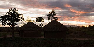
Atiak is a town in the Northern Region of Uganda on the Gulu-Nimule Road, the primary trade route between Uganda and South Sudan.

<span class="mw-page-title-main">Hilary Onek</span> Ugandan politician (born 1948)

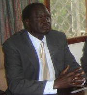
Hilary Obaloker Onek is a Ugandan engineer and politician. He is the current Minister for Relief, Disaster Preparedness and Refugees in the Ugandan Cabinet. He was appointed to that position on 27 May 2013. He replaced Tarsis Kabwegyere. Prior to that, Hilary Onek served as the Minister for Energy & Minerals, from 16 February 2009 until 27 May 2011. Before that, he served as Uganda's Minister of Agriculture, Animal Industry & Fisheries from 2006 to 2009. He is also the elected Member of Parliament (MP) representing Lamwo County, Lamwo District. He was first elected to Parliament in 2001.

<span class="mw-page-title-main">Amuru District</span> District in Northern Uganda, Uganda

Amuru District is a district in Northern Uganda. Like most Ugandan districts, it is named after its 'chief town', Amuru, where the district headquarters are located.

<span class="mw-page-title-main">Nwoya District</span> District in Northern Uganda, Uganda

Nwoya District is a district in Northern Uganda. Like most districts in Uganda, it is named after its main municipal, administrative and commercial center, Nwoya, the location of the district headquarters.

<span class="mw-page-title-main">Lamwo District</span> District in Northern Region of Uganda, Uganda

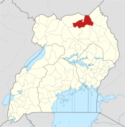
Lamwo District is a district in the Northern Region of Uganda. The town of Lamwo is the site of the district headquarters.

Lamwo is a town in the Northern Region of Uganda and the political and administrative center of Lamwo District.

<span class="mw-page-title-main">Agago District</span> District in Northern Uganda, Uganda

The Agago District is a Ugandan district located in the Northern Region of Uganda.

Kalongo is a town in the Northern Region of Uganda. It is one of the urban centers in Agago District.

The Acholibur–Gulu–Olwiyo Road is a road in the Northern Region of Uganda, connecting the town of Acholibur to the city of Gulu and the town of Olwiyo.

Rwekunye–Apac–Aduku–Lira–Kitgum–Musingo Road is a road in the Northern Region of Uganda, connecting the towns of Masindi Port in Kiryandongo District to Apac in Apac District, Lira in Lira District, Acholibur in Pader District, Kitgum in Kitgum District, and Musingo in Lamwo District at the international border with South Sudan.

Elegu is a town in the Northern Region of Uganda. It sits across the international border from the town of Nimule, South Sudan.

Rwekunye is a settlement in Kiryandongo District in the Western Region of Uganda.

The Kampala–Gulu Highway, also Kampala–Gulu Road, is a road connecting Uganda's capital city of Kampala, in the Central Region, with the city of Gulu, the largest urban centre in the country's Northern Region.

<span class="mw-page-title-main">Acholi people</span> Ethnic group of South Sudan and Northern Uganda

The Acholi people are a Nilotic ethnic group of Luo peoples, found in Magwi County in South Sudan and Northern Uganda, including the districts of Agago, Amuru, Gulu, Kitgum, Nwoya, Lamwo, Pader and Omoro District. The Acholi were estimated to number 2.3 million people and over 45,000 more were living in South Sudan in 2000.

<span class="mw-page-title-main">Aruu Falls</span> Waterfall in Uganda

Aruu Falls, also known as Aruu Falls Camspite, are natural waterfalls located in Northern Uganda along the Gulu Kitgum highway in Pader District. The falls are 47 kilometers away from Gulu, 57 kilometers away from Kitgum, and 386 kilometers away from Kampala, the capital city of Uganda.

References

  1. Uganda District Map
  2. "Distance Between Gulu And Kitgum With Map". Globefeed.com. Retrieved 26 May 2014.
  3. "Map Showing Kampala And Kitgum, With Distance Marker". Globefeed.com. Retrieved 26 May 2014.
  4. "Estimated Population of Kitgum District In 1991, 2002 & 2012". Citypopulation.de. Retrieved 26 May 2014.
  5. "Economic Activities In Kitgum District". Uganda Travel Guide. Retrieved 26 May 2014.
  6. https://blencoweresourcesplc.com/orom-cross-project/
  7. Uganda Red Cross (15 September 2008). "Uganda: Weekly Up Date Report Hepatitis E Epidemic In Kitgum District 8-15 September 2008". Reliefweb.int. Retrieved 26 May 2014.
  8. "Hepatitis E Epidemic Continues to Kill People in Northern Uganda". Uganda Radio Network. 18 March 2009. Retrieved 26 May 2014.
  9. "Uganda: Hepatitis E Deaths, Infections Increase". Daily Monitor via AllAfrica.com. Archived from the original on 10 October 2012. Retrieved 26 May 2014.
  10. Ninsiima, Racheal (1 March 2012). "Omony, Successful Plus-Size Model". The Observer (Uganda) . Retrieved 26 May 2014.