Uganda, officially the Republic of Uganda, is a landlocked country in East Africa. The country is bordered to the east by Kenya, to the north by South Sudan, to the west by the Democratic Republic of the Congo, to the south-west by Rwanda, and to the south by Tanzania. The southern part of the country includes a substantial portion of Lake Victoria, shared with Kenya and Tanzania. Uganda is in the African Great Lakes region, lies within the Nile basin, and has a varied but generally modified equatorial climate. As of 2023, it has a population of around 49.6 million, of which 8.5 million live in the capital and largest city of Kampala.
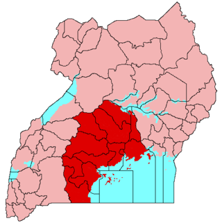
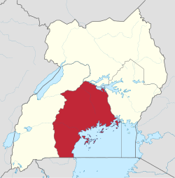
Buganda is a Bantu kingdom within Uganda. The kingdom of the Baganda people, Buganda is the largest of the traditional kingdoms in present-day East Africa, consisting of Buganda's Central Region, including the Ugandan capital Kampala. The 14 million Baganda make up the largest Ugandan region, representing approximately 16% of Uganda's population.
The early history of Uganda comprises the history of Uganda before the territory that is today Uganda was made into a British protectorate at the end of the 19th century. Prior to this, the region was divided between several closely related kingdoms.

Mukono is one of the districts in the Central Region of Uganda. The town of Mukono is home to the district's main commercial center and district headquarters.

Busoga is a kingdom and one of four constitutional monarchies in present-day Uganda. The kingdom is a cultural institution which promotes popular participation and unity among the people of the region through development programs to improve their standard of living.
The Anglican dioceses of Buganda are the Anglican presence in the Central Region, Uganda ; they are part of the Church of Uganda. The remaining dioceses of the Church are in the areas of Eastern Uganda, of Northern Uganda, of Ankole and Kigezi, and of Rwenzori.
The Northern Region is one of four regions in Uganda. As of Uganda's 2014 census, the region's population was 7,188,139.
The following outline is provided as an overview of and topical guide to Uganda:

Lake Wamala is a freshwater lake in Uganda. Its wetlands contain endangered species of birds and animals including the sitatunga. The lake is of traditional and cultural significance to the people of Buganda in Central Uganda.
Lubaga is a hill in Kampala, Uganda's capital and largest city. It comes from the Luganda word okubaga, describing a process of "planning" or "strengthening" a structure while constructing it. For example, okubaga ekisenge means to strengthen the internal structure of a wall while building a house. The name also applies to the neighborhood on the hill.

Muteesa I Royal University (MRU) is a private university in Uganda. It was accredited by the Uganda National Council for Higher Education in 2007 and chartered in 2023. In 2016, Justice Julia Sebutinde was installed as Chancellor of the University, replacing Ronald Muwenda Mutebi II, the founding chancellor who became Visitor of the university.
The Eastern region is one of four regions in the country of Uganda. As of Uganda's 2014 census, the region's population was 9,042,422.
The Western Region of Uganda is one of four regions in the country of Uganda. As of Uganda's 2014 census, the Western region's population was 8,874,862.
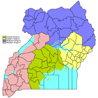
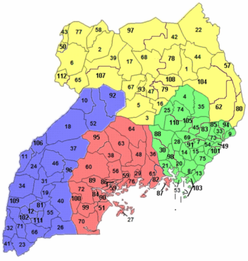
The regions of Uganda are known as Central, Western, Eastern, and Northern. These four regions are in turn divided into districts. There were 56 districts in 2002, which expanded into 111 districts plus one city (Kampala) by 2010.
Busega is a neighborhood within Kampala, Uganda's capital and largest city.

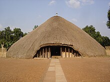
The Kasubi Tombs in Kampala, Uganda, is the site of the burial grounds for four kabakas and other members of the Baganda royal family. As a result, the site remains an important spiritual and political site for the Ganda people, as well as an important example of traditional architecture. It became a UNESCO World Heritage Site in December 2001, when it was described as "one of the most remarkable buildings using purely vegetal materials in the entire region of sub-Saharan Africa".

The Baganda also called Waganda, are a Bantu ethnic group native to Buganda, a subnational kingdom within Uganda. Traditionally composed of 52 clans, the Baganda are the largest people of the Bantu ethnic group in Uganda, comprising 16.5 percent of the population at the time of the 2014 census.

The Bulange (boo-lah-ngeh) is a building in Uganda. It houses the Lukiiko (Parliament) of the Kingdom of Buganda. The Kabaka of Buganda and the Katikkiro of Buganda also maintain offices in the building. The building serves as the administrative headquarters of the Buganda Kingdom.
Kanoni, also Kanoni, Gomba or Kanoni–Gomba, is a town in the Central Region of Uganda. It is the commercial, administrative, and political headquarters of Gomba District.
Buloba is an urban area in Wakiso District in the Buganda Region of Uganda. The area is primarily a middle-class residential neighborhood.