Nakapiripirit District

Last updated

Nakapiripirit District
Nakapiripirit District in Uganda.svg
District location in Uganda
Coordinates: 01°55′N34°40′E / 1.917°N 34.667°E / 1.917; 34.667
CountryFlag of Uganda.svg  Uganda
Region Northern Uganda
Sub-region Karamoja sub-region
Capital Nakapiripirit
Area
  Total4,201.6 km2 (1,622.2 sq mi)
Elevation
1,300 m (4,300 ft)
Population
 (2012 Estimate)
  Total161,600
  Density38.5/km2 (100/sq mi)
Time zone UTC+3 (EAT)
Website www.nakapiripirit.go.ug

Nakapiripirit District is a district in Northern Uganda. Like many Ugandan districts, it is named after its 'chief town', Nakapiripirit, where the district headquarters are located.

Contents

Location

The district is bordered by Napak District to the north, Moroto District to the northeast, Amudat District to the east, Kween District to the southeast, Bulambuli District to the southwest, Kumi District to the west and Katakwi District to the northwest. [1] Nakapiripirit, the main municipal, administrative and commercial center in the district, lies 125 kilometres (78 mi) northeast of Mbale, the nearest large town, [2] and 360 kilometres (220 mi) northeast of Kampala, Uganda's capital and largest city. [3] The coordinates of the district are:01 55N, 34 40E.

Population

The 1991 national population census estimated the district population at about 66,250. In 2002, the national census conducted that year estimated the population of the district at about 90,920. Between 2002 and 2012, it is estimated that the district population has been growing at an annual rate of 6%. In view of those data, it is estimated that in 2012 the population of Nakapiripirit District was about 161,600. [4]

Ethnicities

The majority of the population are Karamojong and the language spoken is the Karamojong language.

Economic activity

The main activity in the district is animal husbandry and the majority of the population are pastoralists. However, in some areas, especially in the south, some agricultural activity takes place. More recently the exploration of the rich mineral landscape has begun in earnest by American, Canadian, Middle Eastern and Indian prospectors. [5]

See also

Related Research Articles

<span class="mw-page-title-main">Mbale District</span> District in Eastern Uganda, Uganda

Mbale District is a district in Eastern Uganda. It is named after the largest city in the district, Mbale, which also serves as the main administrative and commercial center in the sub-region.

<span class="mw-page-title-main">Kotido District</span> District in Northern Uganda, Uganda

Kotido District is a district in Northern Uganda. It is named after its 'chief town', Kotido, where the district headquarters are located.

<span class="mw-page-title-main">Moroto District</span> District in Northern Region of Uganda, Uganda

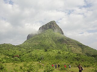
Moroto District is a district in the Northern Region of Uganda. The town of Moroto is the site of the district headquarters.

<span class="mw-page-title-main">Kapchorwa District</span> District in Eastern Uganda, Uganda

Kapchorwa District is a district in the Eastern Region of Uganda. The town of Kapchorwa is the district's main municipal, administrative, and commercial center, and is the site of the district headquarters. It is also the home district of Stephen Kiprotich, the men's marathon gold medalist at the 2012 Summer Olympics, and Joshua Cheptegei, the men's 5,000 m gold medalist at the 2021 Summer Olympics in Tokyo.

<span class="mw-page-title-main">Mbale</span> Place in Eastern Uganda, Uganda

Mbale is a city in the Eastern Region of Uganda. It is the main municipal, administrative, and commercial center of Mbale District and the surrounding sub-region.

<span class="mw-page-title-main">Moroto Town</span> Place in Northern Region, Uganda

Moroto is a town in Moroto District in the Northern Region of Uganda. The town serves as the location of the district headquarters.

<span class="mw-page-title-main">Karamoja</span> Sub Region of Uganda

The Karamoja sub-region, commonly known as Karamoja, is a region in Uganda. It covers an area of 27,528km and comprises the Kotido District, Kaabong District, Karenga District, Nabilatuk District, Abim District, Moroto District, Napak District, Amudat District and Nakapiripirit District. The region is projected to have a population of 1.4 millions in 2022 by UBOS.

Nakapiripirit is a town in the Nakapiripirit District of the Northern Region of Uganda. It is the seat of the district headquarters. As an administrative unit of the district, it is one of the eight sub-counties in the district.

Amuria is a town in the Eastern Region of Uganda. It is the chief municipal, administrative, and commercial center of Amuria District, in the Teso sub-region.

<span class="mw-page-title-main">Bukwo District</span> District in Eastern Uganda, Uganda

Bukwo District is a district in the Eastern Region of Uganda. The town of Bukwo is its main political, administrative, and commercial center and the site of the district headquarters.

Kumi Town, commonly called Kumi, is a town in the Eastern Region of Uganda. It is the main municipal, administrative, and commercial center in Kumi District and the site of the district headquarters.

<span class="mw-page-title-main">Abim District</span> District in Uganda

Abim District is a district in Northern Uganda. It is named after its 'chief town', Abim, where the district headquarters are located.

<span class="mw-page-title-main">Kaabong</span> Ugandan town

Kaabong is a town in the Northern Region of Uganda. It is the chief municipal, administrative and commercial center of the eponymous Kaabong District, and the district headquarters are located in the town.

Moroto Regional Referral Hospital, commonly known as Moroto Hospital is a hospital in the town of Moroto, in Northeastern Uganda. It is the referral hospital for the districts of Abim, Kaabong, Kotido, Moroto and Nakapiripirit and Napak.

<span class="mw-page-title-main">Bulambuli District</span> District in Uganda

Bulambuli District is a district in Eastern Uganda. The district is named after 'chief town', Bulambuli, where the district headquarters are located.

<span class="mw-page-title-main">Amudat District</span> District in Northern Uganda, Uganda

Amudat District is a district in Northern Uganda. Like most Ugandan districts, it is named after its 'chief town', Amudat, where the district headquarters are located.

<span class="mw-page-title-main">Napak District</span> District in Northern Uganda, Uganda

Napak District is a district in Northern Uganda. It is named after Mount Napak, and its headquarters is at Lokitede.

Moroto–Nakapiripirit Road is a road in the Northern Region of Uganda. The road connects the towns of Moroto, the largest town in the Karamoja sub-region, and Nakapiripirit in the same sub-region.

Muyembe–Nakapiripirit Road is a road in the Eastern and Northern regions of Uganda. The road connects the towns of Muyembe in Bulambuli District, to the town of Nakapiripirit in Nakapiripirit District.

Muyembe is a town in the Eastern Region of Uganda.

References

  1. Uganda District Map
  2. "Distance Between Mbale And Nakapiripirit With Map". Globefeeed.com. Retrieved 22 May 2014.
  3. "Map Showing Kampala And Nakapiripirit With Distance Marker". Globefeed.com. Retrieved 22 May 2014.
  4. "Estimated Population of Nakapiripirit District In 1991, 2002 & 2012". Citypopulation.de. Retrieved 22 May 2014.
  5. Musoke, Ronald (21 February 2014). "Grabbing Karamoja's Gold". The Independent (Uganda). Archived from the original on 24 May 2014. Retrieved 23 May 2014.