Lugazi

Last updated
Lugazi
Kawolo
Uganda location map.svg
Red pog.svg
Lugazi
Location in Uganda
Coordinates: 00°22′08″N32°56′25″E / 0.36889°N 32.94028°E / 0.36889; 32.94028
Country Flag of Uganda.svg Uganda
Region Central Region of Uganda
District Buikwe District
Government
  MayorAsea John Bosco Onzuma [1] [2]
Elevation
1,223 m (4,012 ft)
Population
 (2014 Census) [3]
  Total114,163

Lugazi is a town in the Buikwe District of the Central Region of Uganda. The town is also called "Kawolo", and the two names are interchangeably used by the local inhabitants.[ citation needed ]

Contents

Location

The town is on the Kampala-Jinja Highway, approximately 46 kilometres (29 mi) east of Kampala, Uganda's capital and largest city. [4] It is approximately 25.5 kilometres (16 mi), by road, east of Mukono, the nearest large town, also on the Kampala–Jinja Highway. [5] Lugazi sits at an average elevation of 1,223 metres (4,012 ft), above mean sea level. [6] The coordinates of Lugazi are 0°22'08.0"N, 32°56'25.0"E (Latitude:0.368889; Longitude:32.940278). [7]

Points of interest

The following points of interest lie within or close to the town:

Cathedral of Our Lady Queen of Peace Uganda 2012 a010.jpg
Cathedral of Our Lady Queen of Peace

Population

The 2002 national census estimated the population of Lugazi at 27,979. In 2010, the Uganda Bureau of Statistics (UBOS) estimated the population at 34,500. In 2011, UBOS estimated the population at 35,500. [8] In 2014, the national census put the population at 114,163. [3]

Sports

In 2012, a Little League baseball team from Lugazi qualified for the 2012 Little League World Series in Williamsport, Pennsylvania. This was the second ever team from Uganda to qualify and the first to make the trip to the USA. [9] The team that qualified in 2011 were denied visas by the State Department, therefore having to concede the MEA region title to Dhahran, Saudi Arabia.

Lugazi is also the home of the Uganda Revenue Authority SC, a member of the Uganda Premier Soccer League.

See also

Related Research Articles

<span class="mw-page-title-main">Mukono District</span> District in Central Region of Uganda, Uganda

Mukono is one of the districts in the Central Region of Uganda. The town of Mukono serves as the district headquarters and is home to the district's main commercial center.

Bugiri is a town in the Eastern Region of Uganda. It is the chief town of Bugiri District, and the district headquarters are located there. The town was elevated to Municipal Council status in 2019.

<span class="mw-page-title-main">Iganga</span> Ugandan town

Iganga is a town in the Eastern Region of Uganda. It is the main municipal, administrative, and commercial center of Iganga District.

Rukungiri is a town in Rukungiri District of the Western Region of Uganda. It is the site of the district headquarters.

Sembabule is a town in Sembabule District in the Central Region of Uganda. The town is the main municipal, administrative, and commercial center of the district and the site of the district headquarters.

Kayunga is a town in the Central Region of Uganda. It is the main municipal, administrative, and commercial center of Kayunga District.

Luweero is a town in the Central Region of Uganda. It is the main municipal, administrative, and commercial center of Luweero District.

Kakiri is a town located in Wakiso District in the Central Region of Uganda.

<span class="mw-page-title-main">Mukono Town</span> Urban centre in Uganda

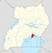
Mukono Town is a municipality in Mukono District in the Central Region of Uganda. The town is administered by the Mukono Town Council. The district headquarters are located in this town.

The Kampala–Jinja Highway is a road in Uganda, connecting the cities of Kampala and Jinja. Sometimes referred to as Kampala–Jinja Road, it is a busy road, with several towns, trading centers and other points of interest along the way. As of October 2016, a new, wider, four-lane dual carriageway expressway, the Kampala–Jinja Expressway, is proposed to be constructed south of the present highway to relieve traffic and complement existing transport infrastructure between Kampala and Jinja.

<span class="mw-page-title-main">Buikwe</span> Town in Central Region, Uganda

Buikwe, sometimes spelled Buyikwe, is a town in Buikwe District, Uganda. It is the administrative center of the district and the location of the district headquarters.

<span class="mw-page-title-main">Bweyogerere</span> Place in Wakiso District, Uganda

Bweyogerere is one of the six townships or wards that constitute Kira Municipality in Wakiso District in southern central Uganda. The other five wards are Kimwaanyi, Kira, Kireka, Kirinnya and Kyaliwajjala.

Nkokonjeru is a town council in Buikwe District in the Central Region of Uganda with villages such as: Namaliiri, Kigulu, Mulajje, Naziwanga, Ndolwa, Buira, Bukasa, Wabiduuku, Nsuube and Nkokonjeru Central. The town's name means "White Chicken".

Busembatya, sometimes spelled Busembatia, is a town in the Eastern Region of Uganda.

Mt. St. Mary's College Namagunga is an all-girl boarding secondary school located in Mukono District in Uganda. The school is affiliated with the Roman Catholic Diocese of Lugazi.

<span class="mw-page-title-main">Namanve</span> Place in Wakiso District, Uganda

Namanve is an area in the Central Region of Uganda. The larger portion of Namanve lies in Kira Municipality, in Wakiso District with portions located in Mukono Municipality, in Mukono District.

Namayingo is a town in Namayingo District in the Eastern Region of Uganda. It is the site of the district headquarters.

Kawolo General Hospital, also Kawolo Hospital, is a hospital in Buikwe District in the Central Region of Uganda.

Nyenga Mission Hospital, whose formal name is St. Francis Hospital Nyenga, but is commonly referred to as Nyenga Hospital, is a non-profit, community hospital in Uganda. It is owned and operated by the Roman Catholic Diocese of Lugazi.

Nagojje is a town in the Buganda Region of Uganda. It is a municipality in Mukono District.

References

  1. Moses Odongo, and Sulaiman Matovu (3 August 2008). "Lugazi Residents Back Land Bill". New Vision (Kampala). Archived from the original on 22 January 2015. Retrieved 21 January 2015.
  2. Nalubwama, Jackie (29 October 2013). "Uganda: Who Owns Lugazi Town?". The Observer (Uganda) via AllAfrica.com . Retrieved 21 January 2015.
  3. 1 2 "UBOS (27 August 2014). "The Population of The Regions of the Republic of Uganda And All Cities And Towns of More Than 15,000 Inhabitants". Citypopulation.de Quoting Uganda Bureau of Statistics (UBOS). Retrieved 26 February 2015.
  4. Google (30 August 2021). "Road Distance Between Kampala And Lugazi With Interactive Map" (Map). Google Maps . Google. Retrieved 30 August 2021.
  5. Google (30 August 2021). "Road Distance Between Mukono Town, Uganda And Lugazi, Uganda With Map" (Map). Google Maps . Google. Retrieved 30 August 2021.
  6. Elevation Map (30 August 2021). "Altitude of Lugazi Town, Central Region, Uganda". Elevationmap.net. Retrieved 30 August 2021.
  7. Google (30 August 2021). "Location of Lugazi Municipality, Central Region, Uganda" (Map). Google Maps . Google. Retrieved 30 August 2021.
  8. UBOS (2011). "Estimated Population of Lugazi In 2002, 2010 & 2011" (PDF). Uganda Bureau of Statistics (UBOS). Archived from the original (PDF) on 7 July 2014. Retrieved 21 January 2015.
  9. Communications Division (16 July 2012). "Lugazi Little League of Uganda Wins Regional Title, to be First African Team In Little League Baseball World Series". Little League Online. Retrieved 21 January 2015.

00°23′00″N32°55′27″E / 0.38333°N 32.92417°E / 0.38333; 32.92417