
DuPage County is a county in the U.S. state of Illinois, and one of the collar counties of the Chicago metropolitan area. As of the 2020 census, the population was 932,877, making it Illinois' second-most populous county. Its county seat is Wheaton.

Cloverdale is a city in Sonoma County, California, United States; it is both the westernmost and the northernmost city in the San Francisco Bay Area. The San Francisco and North Pacific Railroad reached Cloverdale in 1872. The Cloverdale Rancheria of Pomo Indians of California is headquartered there. The population was 8,618 at the 2010 census.
Roselle is a suburb of Chicago and is a village located in both DuPage County and Cook in Illinois. Roselle was first incorporated in 1922 as a bedroom community, with its train stop attracting residents commuting to Chicago or nearby suburbs for their jobs. As of the 2020 census, the village's population was 22,897.

Aurora is a city in the Chicago metropolitan area. Located primarily in DuPage and Kane Counties, it is the second most populous city in Illinois, after Chicago, and the 144th most populous city in the United States. The population was 197,899 at the 2010 census, and was 180,542 at the 2020 census.

Bloomingdale is a village in DuPage County, Illinois, United States, settled in 1833, and 25 miles northwest of downtown Chicago. The population was 22,382 at the 2020 census.
Carol Stream is a village in DuPage County, Illinois, United States, and a suburb of Chicago. Carol Stream was incorporated on January 5, 1959, and named after its founder's daughter. Per the 2020 census, the population was 39,854.

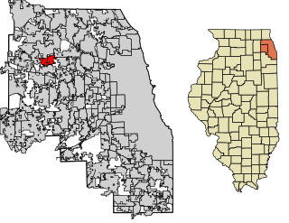
Itasca is a village in DuPage County, Illinois, United States. Per the 2020 Census, the population was 9,543. Located approximately 25 miles northwest of downtown Chicago, Itasca is close to O'Hare International Airport, major expressways and rail transportation. Itasca is home to a country club, a resort and shares a border with Medinah's legendary golf course. The population was 9,725 at the 2020 census. BusinessWeek rated Itasca as the Best Affordable Suburb in the state of Illinois.

Wheaton is a city in Milton and Winfield Townships and is the county seat of DuPage County, Illinois, United States. It is located approximately 25 miles (40 km) west of Chicago. As of the 2020 census, Wheaton's population was 53,970, making it the 27th most populous municipality in Illinois.

The Chicago metropolitan area, also colloquially referred to as Chicagoland, is the metropolitan area containing the City of Chicago, which includes its surrounding suburbs and satellite cities. Encompassing 10,286 square mi, the metropolitan area includes the city of Chicago, its suburbs and hinterland, that span 14 counties across northeast Illinois, northwest Indiana, and southeast Wisconsin. The MSA had a 2020 census population of 9,618,502 and the combined statistical area which spans up to 19 counties had a population of nearly 10 million people. The Chicago area is the fourth largest metropolitan area in North America, the third-largest metropolitan area in the United States, the largest within the entire Midwest, and the largest in the Great Lakes megalopolis. Its urban area is one of the forty largest in the world.

Medinah is an unincorporated community in the state of Illinois and is a northwest suburb of Chicago, located in DuPage County. It is neighbored by the three villages of Roselle, Itasca, and Bloomingdale along old Chicago-Galena highway between Route 19 and 20.
Army Trail Road is a 16.4-mile (26.4 km) county road in parts of DuPage and Kane Counties, Illinois. Army Trail Road begins at Illinois Route 25 in Wayne and ends at the Addison Village Hall east of John F. Kennedy Drive in a cul de sac in Addison. Parts of Army Trail Road are signed as DuPage County Highway 11 and Kane County Highway 20.

The Bloomingdale Trail is a 2.7-mile (4.3 km) elevated rail trail linear park running east–west on the northwest side of Chicago. It is the longest greenway project of a former elevated rail line in the Western Hemisphere, and the second longest in the world, after the Promenade plantee linear park in Paris. In 2015, the City of Chicago converted the former Bloomingdale railway line to an elevated greenway, which forms the backbone of the 606 trail network. The Bloomingdale Trail elevated park is in the Logan Square, Humboldt Park, and West Town community areas.

The 8th congressional district of Illinois is a congressional district in the U.S. state of Illinois that has been represented by Democrat Raja Krishnamoorthi since 2017.
Roger Jenisch was a Republican member of the Illinois State Representative for a single term from 2005 to 2007.
Carole Pankau is a former Republican Illinois State Senator, representing the 23rd district from 2005 to 2013. Pankau previously served as State Representative from 1993 to 2005.

Bloomingdale Township is one of nine townships in DuPage County, Illinois, USA. As of the 2020 census, its population was 111,875 and it contained 42,488 housing units.
The Steed-Kisker culture is a cultural phase that is part of the larger Central Plains Village tradition of the Plains Village period. This term applies to the prehistoric peoples who occupied the Great Plains region of the modern-day United States in prehistoric times.
Eola is an unincorporated community in Naperville Township, DuPage County, Illinois, United States. Although unincorporated, it has a post office, and has been given the zip code 60519. Eola is located near the western border of DuPage County, just north of Metra's BNSF Railway Line, and is surrounded by the city limits of Aurora. The community is the site of a BNSF Railway yard. Metra's BNSF Railway Line passes through the community but no longer stops there. A potential station would open on the STAR Line to transfer with the BNSF Line. In 2010, the population for Eola's zip code was 108. Eola is believed to be an acronym for End of Line Aurora.
William Aloysius Redmond (1908-1992) was a member of the Illinois House of Representatives representing portions of DuPage County from 1959 until his retirement in 1981. During the 79th, 80th and 81st general assemblies, he served as Speaker of the House.

Cloverdale station is a bus station and future intermodal station in Cloverdale, California. It is served by Amtrak Thruway and Sonoma County Transit buses. Additional service to Sonoma County Airport station is provided by Sonoma County Transit under contract by Sonoma–Marin Area Rail Transit.


