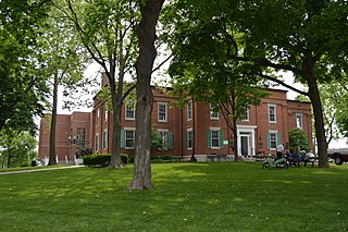
Monroe County is a county located in the U.S. state of Illinois. According to the 2020 census, it had a population of 34,962. Its county seat and largest city is Waterloo.

DuPage County is a county in the U.S. state of Illinois, and one of the collar counties of the Chicago metropolitan area. As of the 2020 census, the population was 932,877, making it Illinois' second-most populous county. Its county seat is Wheaton.

Lisle is a village in DuPage County, Illinois, United States. The population was 22,390 at the 2010 census, and in 2019 the population was recorded to be 23,270. It is part of the Chicago metropolitan area and the Illinois Technology and Research Corridor. It is also the headquarters of the Nuclear Regulatory Commission Region III.

Wayne is a village in DuPage and Kane counties, Illinois, United States. The eastern portion, in DuPage County, is in Wayne Township, while the western portion, in Kane County, is in St. Charles Township. The population was 2,286 as of the 2020 census.

Wheaton is a city in Milton and Winfield Townships and is the county seat of DuPage County, Illinois, United States. It is located approximately 25 miles (40 km) west of Chicago. As of the 2020 census, Wheaton's population was 53,970, making it the 27th most populous municipality in Illinois.

Winfield is an incorporated village located in Milton and Winfield Townships, DuPage County, Illinois, United States. The population was 9,080 at the 2010 census and as of 2019, the estimated population was 9,636.
Solway Township is a township in Saint Louis County, Minnesota, United States. The population was 1,944 at the 2010 census. Solway Township was named after Solway Firth.

The DuPage River is a 28.3-mile-long (45.5 km) tributary of the Des Plaines River in the U.S. state of Illinois.
Army Trail Road is a 16.4-mile (26.4 km) county road in parts of DuPage and Kane Counties, Illinois. Army Trail Road begins at Illinois Route 25 in Wayne and ends at the Addison Village Hall east of John F. Kennedy Drive in a cul de sac in Addison. Parts of Army Trail Road are signed as DuPage County Highway 11 and Kane County Highway 20.

Wayne Township is one of nine townships in DuPage County, Illinois, USA. As of the 2020 census, its population was 64,427 and it contained 21,788 housing units.

Winfield Township is one of nine townships in DuPage County, Illinois, USA. As of the 2020 census, its population was 45,836 and it contained 16,445 housing units. It is the least populous of the DuPage County Townships.
Munger is an unincorporated community in Solway Township, Saint Louis County, Minnesota, United States.

St. Charles is a city in DuPage and Kane counties in the U.S. state of Illinois. It lies roughly 40 miles (64 km) west of Chicago on Illinois Route 64. Per the 2020 census, the population was 33,081. The official city slogan is "Pride of the Fox", after the Fox River that runs through the center of town. St. Charles is part of a tri-city area along with Geneva and Batavia, all western suburbs of similar size and socioeconomic condition.
Munger Road is a road in DuPage and Cook counties in Illinois, running through the villages of Bartlett and Wayne. It runs north–south for 4.12 miles (6.63 km) from West Bartlett Road to Smith Road.
Fullersburg is a former village in Downers Grove Township and York Township, DuPage County, Illinois near the Cook County border. Though never incorporated in its own name, the area is historically important to the development of Hinsdale and Oak Brook, Illinois.
Belmont is a former village and unincorporated community in Lisle Township, DuPage County, Illinois, United States. It was first settled in 1835. It was incorporated as a village in 1980 and disincorporated in 2004, after which portions of the area were annexed into nearby Downers Grove. It is typically defined as the area west of Denburn Woods and east of I-355, in between Downers Grove and Woodridge. The Belmont Train Station is in the town. St. Joseph Creek, a tributary of the DuPage River, runs through the town. Prior to 2008, Belmont had a small business district along Belmont Road, most of which was demolished in order to make way for a new underpass beneath the train tracks. A post office under the name "Belmont Valley" with the ZIP Code 60516 was once located on Belmont Road, and closed on October 1, 2004. The community and surrounding valley are served by the Northwest Belmont Water Improvement Association, which in 2009, reported 3,075 people in their service area. In 2019, the community had an estimated population of 5,250.
Munger is an unincorporated community in Pike County, Illinois, United States. The location is adjacent to the Pike-Adams county line on the Mississippi floodplain two miles east of the Mississippi River and northeast of East Hannibal. Fall Creek is approximately 1.5 miles to the northeast. The Burlington Northern Railroad line passes by the community.
Butterfield is an unincorporated community spanning Milton Township and York Township, DuPage County, Illinois, United States. Butterfield is located north of Butterfield Road, west of Finley Road, south of 22nd Street, and east of the East Branch of the DuPage River. It is nestled in between the communities of Glen Ellyn, Downers Grove, and Lombard.


