Hinsdale, Illinois | |
---|---|
Village | |
Village of Hinsdale | |
Coordinates: 41°48′2″N87°55′41″W / 41.80056°N 87.92806°W | |
Country | United States |
State | Illinois |
Counties | Cook, DuPage |
Townships | Downers Grove, York, Lyons, Proviso |
Incorporated | April 1, 1873 |
Government | |
• Type | Council–manager |
• President | Peter Sweeney |
Area | |
• Total | 4.66 sq mi (12.07 km2) |
• Land | 4.62 sq mi (11.97 km2) |
• Water | 0.04 sq mi (0.10 km2) 0.65% |
Population (2020) | |
• Total | 17,395 |
• Density | 3,763/sq mi (1,452.75/km2) |
Down 3.07% from 2000 | |
Standard of living (2015-2019) | |
• Per capita income | $114,121 |
• Median home value | $969,219 |
ZIP code(s) | 60521 |
Area code(s) | 630 and 331 |
Geocode | 35307 |
FIPS code | 17-35307 |
Website | www |
Hinsdale is a village in Cook and DuPage counties in the U.S. state of Illinois. [2] Hinsdale is a western suburb of Chicago. The population was 17,395 at the 2020 census, most of whom lived in DuPage County.
Hinsdale is located 20 miles (32 km) west of Chicago and is bordered by Western Springs to the east, Clarendon Hills and Westmont to the west, Oak Brook to the north, and Burr Ridge and Willowbrook to the south. The eastern boundary of Hinsdale is Interstate 294 and the western boundary is Route 83.
According to the 2021 census gazetteer files, Hinsdale has a total area of 4.66 square miles (12.07 km2), of which 4.62 square miles (11.97 km2) (or 99.18%) is land and 0.04 square miles (0.10 km2) (or 0.82%) is water. [3]
Census | Pop. | Note | %± |
---|---|---|---|
1880 | 819 | — | |
1890 | 1,584 | 93.4% | |
1900 | 2,578 | 62.8% | |
1910 | 2,451 | −4.9% | |
1920 | 4,042 | 64.9% | |
1930 | 6,923 | 71.3% | |
1940 | 7,336 | 6.0% | |
1950 | 8,676 | 18.3% | |
1960 | 12,859 | 48.2% | |
1970 | 15,918 | 23.8% | |
1980 | 16,726 | 5.1% | |
1990 | 16,029 | −4.2% | |
2000 | 17,349 | 8.2% | |
2010 | 16,816 | −3.1% | |
2020 | 17,395 | 3.4% | |
U.S. Decennial Census [4] |
As of the 2020 census, [5] there were 17,395 people, 5,809 households, and 4,817 families residing in the village. The population density was 3,732 inhabitants per square mile (1,441/km2). There were 6,124 housing units at an average density of 1,314 per square mile (507/km2). The racial makeup of the village was 77.33% White, 1.67% African American, 0.17% Native American, 12.44% Asian, 0.03% Pacific Islander, 1.27% from other races, and 7.09% from two or more races. Hispanic or Latino of any race were 5.45% of the population.
There were 5,809 households, out of which 50.4% had children under the age of 18 living with them, 75.02% were married couples living together, 6.13% had a female householder with no husband present, and 17.08% were non-families. 15.84% of all households were made up of individuals, and 10.23% had someone living alone who was 65 years of age or older. The average household size was 3.30 and the average family size was 2.94.
The village's age distribution consisted of 32.2% under the age of 18, 4.0% from 18 to 24, 18.5% from 25 to 44, 31.7% from 45 to 64, and 13.6% who were 65 years of age or older. The median age was 42.3 years. For every 100 females, there were 102.5 males. For every 100 females age 18 and over, there were 98.0 males.
The median income for a household in the village was $206,701, and the median income for a family was $244,598. Males had a median income of $156,007 versus $56,484 for females. The per capita income for the village was $106,061. About 0.5% of families and 1.9% of the population were below the poverty line, including 0.5% of those under age 18 and 7.0% of those age 65 or over.
Race / Ethnicity | Pop 2010 [6] | Pop 2020 [7] | % 2010 | % 2020 |
---|---|---|---|---|
White alone (NH) | 14,663 | 13,226 | 87.2% | 76.03% |
Black or African American alone (NH) | 212 | 282 | 1.26% | 1.62% |
Native American or Alaska Native alone (NH) | 6 | 15 | 0.04% | 0.09% |
Asian alone (NH) | 1,075 | 2,161 | 6.39% | 12.42% |
Pacific Islander alone (NH) | 5 | 4 | 0.03% | 0.02% |
Some Other Race alone (NH) | 12 | 54 | 0.07% | 0.31% |
Mixed Race/Multi-Racial (NH) | 251 | 705 | 1.49% | 4.05% |
Hispanic or Latino (any race) | 592 | 948 | 3.52% | 5.45% |
Total | 16,816 | 17,395 | 100.00% | 100.00% |
Note: the US Census treats Hispanic/Latino as an ethnic category. This table excludes Latinos from the racial categories and assigns them to a separate category. Hispanics/Latinos can be of any race.
Hinsdale's downtown area is a National Register Historic District. [8] The downtown area is located in the center of town and is remarkably little changed considering the many teardowns that have occurred over time. There are restaurants, different types of shops, and various services including the primary train station.
The Robbins Park district just east of downtown, bounded by Garfield Street and County Line Road, and Hinsdale Avenue and 9th Street, is a National Register Historic District also. [8] The district includes two of Hinsdale's seven buildings individually listed on the National Register of Historic Places, as well as seven of seventeen Hinsdale Historic Landmarks. [9]
The six individual Hinsdale buildings on the National Register of Historic Places are the Orland P. Bassett House at 329 E. Sixth St., the Robert A. and Mary Childs House at 318 S. Garfield Ave., Immanuel Evangelical Church at 302 S. Grant St., the Francis Stuyvesant Peabody House at 8 E. Third St. and the William Whitney House at 142 E. First St. [8]
Another significant architectural landmark is the R. Harold Zook Home and Studio, which was originally located at 327 S. Oak Street and was saved from demolition in 2005 by relocation to the Katherine Legge Memorial Park, 5941 S. County Line Road. [10]
To address Hinsdale's legacy of important architectural landmarks, the Hinsdale Historical Society runs the Roger & Ruth Anderson Architecture Center, which advocates for the preservation of Hinsdale's historical architecture and serves as an archive and resource. [11]
The village was incorporated on April 1, 1873. [12] Law enforcement is provided by the Hinsdale Police Department. [13] The Hinsdale Fire Department was established in 1893. [14]
The community is served by the United States Postal Service Hinsdale Post Office. [15]
Hinsdale is served by a network of major federal, state, and county roads, including the Tri-State Tollway (Interstate 294), U.S. Route 34 and Illinois Route 83. Including by Metra's BNSF Line at three stations: Highlands, Hinsdale, and West Hinsdale. Additionally, Pace operates connecting bus services. Currently, Pace bus lines 663 and 668 serve Hinsdale.
UChicago Medicine AdventHealth Hinsdale hospital, operated by AdventHealth, founded in 1904, is a level-two trauma center and DuPage County's only teaching hospital. It has been ranked among 100 best hospitals in the country. [16]
Community Consolidated School District 181 and the Hinsdale Township High School District 86 serve Hinsdale's youth. [17] The high school district has its headquarters in Hinsdale. [18]
The School District 181 elementary schools within Hinsdale include The Lane School, Madison School, Monroe School, and Oak School. Elementary schools in District 181 that are not in Hinsdale include Prospect School, Elm School, and Walker School. Hinsdale Middle School, operated by the elementary school district, is in Hinsdale. Clarendon Hills Middle School, which also is in District 181, is in Clarendon Hills. St Isaac Jogues is a K-8 Catholic Grade School also located in Hinsdale.
Hinsdale Central High School (formerly Hinsdale Township High School) is located in Hinsdale. [19]
The Hinsdale Public Library is located in the west wing of the Memorial Building. [17] The library opened in August 1893. The Memorial Building, the library's first permanent residence, was completed in 1929. D.K. Pearson, a director of the library association, donated his house and a portion of his estate to the library system; the donation funded a 1957 addition to the library.[ citation needed ]
In 1988, the Memorial Building received an addition on the west side, and the library and the village administration swapped places. [20]
While many Hinsdale residents commute to jobs throughout the Chicago metropolitan area, Hinsdale is also the home of many small and medium-sized businesses.
Non-profit organizations such as Hinsdale Historical Society [21] and Hinsdale Humane Society [22] are also based there.
According to Hinsdale's 2020 Comprehensive Annual Financial Report, [23] the top employers in the city are:
# | Employer | # of Employees |
---|---|---|
1 | UChicago Medicine AdventHealth Hinsdale Hospital | 1,555 |
2 | RML Specialty Hospital | 800 |
3 | Hinsdale Township High School District 86 | 620 |
4 | Community Consolidated School District 181 | 550 |
5 | CWT | 220 |
6 | Coldwell Banker | 150 |
The Katherine Legge Memorial Park and Lodge, located on 52 acres (21 ha) of woodland, was donated to the Village of Hinsdale in 1973. The lodge, built in 1927, may be rented for private and corporate events such as banquets, meetings, parties, picnics, receptions, and weddings. [24] The park has a clubhouse with meeting rooms, a football/soccer field, a picnic area, playground apparatus, a scenic open space, a shelter, a frisbee golf course, a sledding hill, and four platform tennis courts. [25]
The 3-acre (1.2 ha) Hinsdale Community Swimming Pool is Hinsdale's public pool. The 14.7-acre (5.9 ha) Veeck Park is Hinsdale's skate park and contains a baseball field, 4 soccer/football fields, a playground, an awning for shelter in case it rains, and a sandbox by the playground. The 8.3-acre (3.4 ha) Brook Park has a ball field, a football/soccer field, a playground apparatus, and four tennis courts. The 6.55-acre (2.65 ha) Burns Field has ice skating, a covered picnic area, a playground, bathrooms/warming house, six tennis courts, 2 platform tennis courts, sand volleyball court and basketball court. The 8.82-acre (3.57 ha) Pierce Park has a ball field, a football/soccer field, a picnic area, a playground apparatus, a shelter, and two tennis courts. The 14.50-acre (5.87 ha) Robbins Park has a football/soccer field, a playground apparatus, and two tennis courts. The 2.33-acre (0.94 ha) Stough Park has ice skating, a playground apparatus, and two tennis courts. [25]
The 4.04-acre (1.63 ha) Brush Hill Area has scenic open space and a sledding hill. The 1.8-acre (0.73 ha) Burlington Park has scenic open space. The 1.03-acre (0.42 ha) Dietz Park has a playground apparatus. The .91-acre (0.37 ha) Ehret Park has a shelter and scenic open space. The .98-acre (0.40 ha) Eleanor's Park has scenic open space. The 4.02-acre (1.63 ha) Highland Park has scenic open space. The 2.82-acre (1.14 ha) Melin Park has a playground apparatus. The 4.36-acre (1.76 ha) Memorial Building Grounds has scenic open space. The 2.33-acre (0.94 ha) Stough Park has scenic open space. The .89-acre (0.36 ha) Washington Circle has scenic open space. The 1.1-acre (0.45 ha) Woodland Park has scenic open space. [25]
Burr Ridge is a village in Cook and DuPage counties in the U.S. state of Illinois. Per the 2020 census, the population was 11,192.
Glenview is an incorporated village located in Cook County, Illinois, United States, approximately 15 miles northwest of the Chicago Loop. Per the 2020 census, the population was 48,705. The current Village President is Michael Jenny.
Park Forest is a village located south of Chicago in Cook County, Illinois, with a small southern portion in Will County, Illinois, United States. The village was originally designed by Loebl Schlossman & Bennett as a planned community for veterans returning from World War II. As of the 2020 census, the village had a population of 21,687.
Westchester is a village in Cook County, Illinois, United States. It is a western suburb of Chicago. The population was 16,892 at the 2020 census.
Gilberts is a village in Kane County, Illinois, United States. The population was 8,366 at the 2020 census.
Grayslake is a village in Lake County, Illinois, United States. It is located in the Chicago metropolitan area, about 40 miles (64 km) north of Chicago's downtown, 14 miles (23 km) west of Lake Michigan, and 15 miles (24 km) south of the Wisconsin border. The village's population at the 2020 census was 21,248.
Lakemoor is a village in Lake and McHenry counties in the U.S. state of Illinois. Per the 2020 census, the population was 6,182.
Glen Carbon is a village in Madison County, Illinois, United States, 14 miles (23 km) northeast of St. Louis. The population was 13,842 at the 2020 census.
Lake in the Hills is a village in McHenry County, Illinois, United States. As of the 2020 census, the population was 28,982.
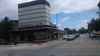
Sterling is a city in Whiteside County, Illinois, United States, along the Rock River. The population was 14,782 at the 2020 census, down from 15,370 in 2010. Formerly nicknamed "Hardware Capital of the World", the city has long been associated with manufacturing and the steel industry.
Sunset Hills is a city in south St. Louis County, Missouri, United States. As of the 2020 United States Census, the city's population was 9,198.
Obetz is a City in Franklin County, Ohio, United States. The population was 5,489 at the 2020 census.
Warminster Township, also referred to as Warminster, is located in Bucks County, Pennsylvania, United States. It was formally established in 1711. The township is 13.7 miles north of Philadelphia and had a population of 33,603 according to the 2020 U.S. census.
Atascocita is a census-designated place (CDP) in Harris County, Texas, United States, within the Houston metropolitan area. As of the 2020 census it had a population of 88,174. It is located north and south of Farm to Market Road 1960 about 6 miles (10 km) east of Humble and 18 miles (29 km) northeast of downtown Houston in northeastern Harris County.
St. Peters is a city in St. Charles County, Missouri, United States. The population was 57,732 at the 2020 census, making it the eleventh-largest city in Missouri. It is a northwestern suburb of St. Louis.
Delhi Township is one of the twelve townships of Hamilton County, Ohio, United States. The 2020 census found 28,760 people in the township. It is the only Delhi Township statewide.
Brookhaven is a city in the northeastern suburbs of Atlanta that is located in western DeKalb County, Georgia, United States, directly northeast of Atlanta. On July 31, 2012, Brookhaven was approved in a referendum to become DeKalb County's 11th city. Incorporation officially took place on December 17, 2012, on which date municipal operations commenced. With a population of around 55,366 as of 2021, it is the largest city in DeKalb County. The new city stretches over 12 square miles (31 km2).
Urbana is a suburban census-designated place located in Frederick County, Maryland, United States. It lies at the I-270/MD 80 interchange, approximately 7.5 miles (12.1 km) south-east of Frederick and about 37 miles (60 km) north-west of Washington, D.C. Urbana started to develop circa 1999 and, as of the 2010 census, had a population of 9,175. It is part of the Washington metropolitan area.
Homecrest is a neighborhood situated in the New York City borough of Brooklyn, sometimes considered as part of Sheepshead Bay. It is bordered by Kings Highway to the north, Avenue X to the south, Coney Island Avenue to the west, and Ocean Avenue to the east.
O'Fallon is a city in St. Charles County, Missouri, United States. It is part of the St. Louis metropolitan statistical area, located along Interstates 64 and 70 between Lake St. Louis and St. Peters. As of the 2020 census, O'Fallon had a population of 91,316, making it the most populous suburb of St. Louis, as well as the most populous municipality in St. Charles County and the 7th most populous in Missouri. O'Fallon's namesake in St. Clair County, Illinois, is also part of the St. Louis region. The two cities are one of the few pairs of same-named municipalities to be part of the same metro area.
{{cite web}}
: CS1 maint: archived copy as title (link)