Washington County, Illinois

Last updated

Washington County
Wash Co IL Courthouse after 2016 Renovations.png
Wash Co IL Seal in Color and Higher Quality.png
Map of Illinois highlighting Washington County.svg
Location within the U.S. state of Illinois
Illinois in United States.svg
Illinois's location within the U.S.
Coordinates: 38°21′N89°25′W / 38.35°N 89.42°W / 38.35; -89.42
CountryFlag of the United States.svg United States
StateFlag of Illinois.svg  Illinois
FoundedJanuary 2, 1818
Named for George Washington
Seat Nashville
Largest cityNashville
Area
  Total564 sq mi (1,460 km2)
  Land563 sq mi (1,460 km2)
  Water1.3 sq mi (3 km2)  0.2%
Population
 (2020)
  Total13,761
  Density24/sq mi (9.4/km2)
Time zone UTC−6 (Central)
  Summer (DST) UTC−5 (CDT)
Congressional district 12th
Website www.washingtonco.illinois.gov

Washington County is a county located in the U.S. state of Illinois. As of the 2020 census, it had a population of 13,761. [1] Its county seat is Nashville. [2] It is located in the southern portion of Illinois known locally as "Little Egypt".

Contents

History

Washington County was formed on January 2, 1818, out of St. Clair County. It was named for George Washington. Despite its relative proximity to the Illinois suburbs of St. Louis, Missouri, the county is not considered part of the St. Louis metropolitan area, also known as the Metro-East. In 1813, the Lively Massacre occurred near Little Crooked Creek. In 1959, the state established the Washington County State Recreation Area. [3] Washington County was initially settled by immigrants from Kentucky who moved northward out of that state in the early 1800s. In the late 1800s there were (relatively) large numbers of immigrants who settled in Washington County, and by the early 1900s there were large numbers of first-generation immigrants still living in Washington County. They primarily came from the four countries of Germany, Poland, Ireland and England. [4]

Geography

According to the U.S. Census Bureau, the county has a total area of 564 square miles (1,460 km2), of which 563 square miles (1,460 km2) is land and 1.3 square miles (3.4 km2) (0.2%) is water. [5] There are many lakes, rivers, streams, and creeks in this area, including the Kaskaskia River, which is the county's northern border.

Climate and weather

Nashville, Illinois
Climate chart (explanation)
J
F
M
A
M
J
J
A
S
O
N
D
 
 
2.2
 
 
38
22
 
 
2.3
 
 
44
27
 
 
3.5
 
 
56
35
 
 
3.9
 
 
67
45
 
 
4.1
 
 
76
55
 
 
3.7
 
 
85
64
 
 
3.7
 
 
88
68
 
 
2.7
 
 
87
65
 
 
3.2
 
 
80
58
 
 
3
 
 
69
47
 
 
3.8
 
 
54
37
 
 
3
 
 
42
26
Average max. and min. temperatures in °F
Precipitation totals in inches
Source: The Weather Channel [6]
Metric conversion
J
F
M
A
M
J
J
A
S
O
N
D
 
 
55
 
 
3
−6
 
 
59
 
 
7
−3
 
 
88
 
 
13
2
 
 
98
 
 
19
7
 
 
104
 
 
24
13
 
 
93
 
 
29
18
 
 
93
 
 
31
20
 
 
69
 
 
31
18
 
 
82
 
 
27
14
 
 
76
 
 
21
8
 
 
96
 
 
12
3
 
 
76
 
 
6
−3
Average max. and min. temperatures in °C
Precipitation totals in mm

In recent years, average temperatures in Nashville have ranged from a low of 22 °F (−6 °C) in January to a high of 88 °F (31 °C) in July, although a record low of −21 °F (−29 °C) was recorded in December 1989 and a record high of 106 °F (41 °C) was recorded in July 1980. Average monthly precipitation ranged from 2.18 inches (55 mm) in January to 4.10 inches (104 mm) in May. [6] On November 17, 2013, an EF4 tornado swept through the area, destroying homes and causing two fatalities.

Public transit

Major highways

Adjacent counties

Demographics

Historical population
CensusPop.Note
1820 1,517
1830 1,67510.4%
1840 4,810187.2%
1850 6,95344.6%
1860 13,73197.5%
1870 17,59928.2%
1880 21,11220.0%
1890 19,262−8.8%
1900 19,5261.4%
1910 18,759−3.9%
1920 18,035−3.9%
1930 16,286−9.7%
1940 15,801−3.0%
1950 14,460−8.5%
1960 13,569−6.2%
1970 13,7801.6%
1980 15,47212.3%
1990 14,965−3.3%
2000 15,1481.2%
2010 14,716−2.9%
2020 13,761−6.5%
2023 (est.)13,536 [7] −1.6%
U.S. Decennial Census [8]
1790-1960 [9] 1900-1990 [10]
1990-2000 [11] 2010 [12]

As of the 2010 United States Census, there were 14,716 people, 5,926 households, and 4,112 families residing in the county. [13] The population density was 26.2 inhabitants per square mile (10.1/km2). There were 6,534 housing units at an average density of 11.6 per square mile (4.5/km2). [5] The racial makeup of the county was 97.7% white, 0.7% black or African American, 0.3% Asian, 0.1% American Indian, 0.4% from other races, and 0.8% from two or more races. Those of Hispanic or Latino origin made up 1.3% of the population. [13] In terms of ancestry, 53.6% were German, 14.0% were Polish, 13.1% were Irish, 7.7% were English, and 6.1% were American. [14]

Of the 5,926 households, 30.1% had children under the age of 18 living with them, 57.6% were married couples living together, 7.3% had a female householder with no husband present, 30.6% were non-families, and 25.9% of all households were made up of individuals. The average household size was 2.44 and the average family size was 2.93. The median age was 42.3 years. [13]

The median income for a household in the county was $51,440 and the median income for a family was $64,171. Males had a median income of $44,272 versus $30,683 for females. The per capita income for the county was $24,846. About 5.5% of families and 9.1% of the population were below the poverty line, including 13.2% of those under age 18 and 8.9% of those age 65 or over. [15]

Education

The county is served by six school districts: [16]

Communities

Cities

Villages

Unincorporated communities

Townships

Washington County is divided into these townships:

Politics

Washington is a rural conservative county in Southern Illinois that has always trended Republican in presidential elections. The only Democrat to win a majority of the county's ballots since the Civil War was Franklin D. Roosevelt in his 1932 landslide. Historically, the county was dominated by organized labor and family farms. The area tends to be economically and socially conservative.

United States presidential election results for Washington County, Illinois [17]
Year Republican Democratic Third party
No.%No.%No.%
2020 6,11577.20%1,64120.72%1652.08%
2016 5,57174.90%1,44819.47%4195.63%
2012 4,79264.45%2,45032.95%1932.60%
2008 4,47356.39%3,34242.13%1171.48%
2004 5,07262.59%2,98636.85%460.57%
2000 4,35360.98%2,63836.96%1472.06%
1996 3,33948.20%2,74439.61%84412.18%
1992 3,00339.75%2,98639.52%1,56620.73%
1988 4,12760.04%2,68939.12%580.84%
1984 5,12968.24%2,36331.44%240.32%
1980 5,35468.98%2,15827.80%2503.22%
1976 4,48557.18%3,22241.08%1371.75%
1972 5,17968.85%2,32730.94%160.21%
1968 4,79363.32%2,09327.65%6839.02%
1964 3,84051.13%3,67048.87%00.00%
1960 5,05361.95%3,09337.92%110.13%
1956 5,29965.14%2,82034.67%160.20%
1952 5,54666.17%2,82433.70%110.13%
1948 4,54461.99%2,73737.34%490.67%
1944 5,42866.31%2,72333.26%350.43%
1940 5,70161.82%3,47937.73%420.46%
1936 4,54051.20%4,11946.45%2092.36%
1932 3,07638.81%4,69659.25%1541.94%
1928 3,63855.90%2,84843.76%220.34%
1924 3,44456.43%1,71728.13%94215.44%
1920 4,51970.76%1,10217.26%76511.98%
1916 4,65760.95%2,79436.57%1902.49%
1912 1,05824.99%1,65439.06%1,52235.95%
1908 2,35553.87%1,83041.86%1874.28%
1904 2,37457.30%1,50436.30%2656.40%
1900 2,35151.81%2,08145.86%1062.34%
1896 2,35153.30%1,97944.87%811.84%
1892 1,95647.35%1,86845.22%3077.43%

Media

WNSV in Nashville is the only radio station in the county.

The two weekly newspapers in the county are The Nashville News, located in Nashville, and The Okawville Times, which is based in Okawville.

See also

Related Research Articles

<span class="mw-page-title-main">Putnam County, Illinois</span> County in Illinois, United States

Putnam County is the least extensive county in the U.S. state of Illinois. According to the 2020 census, it had a population of 5,637. The county seat is Hennepin. The county was formed in 1825 out of Fulton County and named after Israel Putnam, who was a general in the American Revolution. Putnam County is part of the Ottawa, IL Micropolitan Statistical Area.

<span class="mw-page-title-main">Montgomery County, Illinois</span> County in Illinois, United States

Montgomery County is a county located in the U.S. state of Illinois. According to the 2020 census, it had a population of 28,288. Its county seat is Hillsboro.

<span class="mw-page-title-main">Scott County, Illinois</span> County in Illinois, United States

Scott County is a county located in the U.S. state of Illinois. According to the 2020 census, it had a population of 4,949, making it the fourth-least populous county in Illinois. Its county seat is Winchester.

<span class="mw-page-title-main">Perry County, Illinois</span> County in Illinois, United States

Perry County is in Illinois. According to the 2020 census, it had a population of 20,945. Its county seat is Pinckneyville. It is located in the southern portion of Illinois known as "Little Egypt".

<span class="mw-page-title-main">Marion County, Illinois</span> County in Illinois, United States

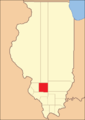
Marion County is a county located in the U.S. state of Illinois. According to the 2020 census, it had a population of 37,729. Its county seat is Salem.

<span class="mw-page-title-main">Cumberland County, Illinois</span> County in Illinois, United States

Cumberland County is a county located in the U.S. state of Illinois. As of the 2020 census, the population was 10,450. Its county seat is Toledo.

<span class="mw-page-title-main">Hoyleton, Illinois</span> Village in Illinois, United States

Hoyleton is a village in Washington County, Illinois, United States. The population was 531 at the 2010 census. It is the hometown of former Montréal Expos and San Francisco Giants left-handed pitcher Kirk Rueter.

<span class="mw-page-title-main">Irvington, Illinois</span> Village in Illinois, United States

Irvington is a village in Washington County, Illinois, United States. The population was 659 at the 2010 census.

<span class="mw-page-title-main">Nashville, Illinois</span> City in Illinois, United States

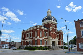
Nashville is a city in Washington County, Illinois, United States. As of the 2020 census, the city population was 3,105. It is the county seat of Washington County.

<span class="mw-page-title-main">Oakdale, Illinois</span> Village in Illinois, United States

Oakdale is a village in Washington County, Illinois, United States. The population was 221 at the 2010 census.

<span class="mw-page-title-main">Okawville, Illinois</span> Village in Illinois, United States

Okawville is a village in Washington County, Illinois, United States. The population was 1,434 at the 2010 census.

<span class="mw-page-title-main">Richview, Illinois</span> Village in Illinois, United States

Richview is a village in Washington County, Illinois, United States. The population was 253 at the 2010 census.

<span class="mw-page-title-main">Venedy, Illinois</span> Village in Illinois, United States

Venedy is a village in Washington County, Illinois, United States. The population was 138 at the 2010 census.

<span class="mw-page-title-main">Irvington, Kentucky</span> City in Kentucky, United States

Irvington is a home rule-class city in Breckinridge County, Kentucky, in the United States. The population was 1,181 at the 2010 census.

<span class="mw-page-title-main">Oakdale, Minnesota</span> City in Minnesota, United States

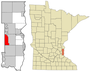
Oakdale is a city in Washington County, Minnesota, United States. It is a suburb of Saint Paul and is on the eastern side of the Twin Cities Metropolitan area. The population was 28,303 at the 2020 census. Oakdale is the 36th largest city in Minnesota by population.

<span class="mw-page-title-main">Oakdale, Nebraska</span> Village in Antelope County, Nebraska, United States

Oakdale is a village in Antelope County, Nebraska, United States. The population was 322 at the 2010 census.

<span class="mw-page-title-main">Oakdale, Pennsylvania</span> Borough in Pennsylvania, United States

Oakdale is a borough in Allegheny County, Pennsylvania, United States. The population was 1,475 at the 2020 census. It is a suburb of Pittsburgh.

<span class="mw-page-title-main">Irvington, Virginia</span> Town in Virginia, United States

Irvington is a town on the Rappahannock River in Lancaster County, Virginia, United States. The population was 432 at the 2010 census. Located on a peninsula known as the Northern Neck, it has been designated a historic district.

<span class="mw-page-title-main">Casner Township, Jefferson County, Illinois</span> Township in Illinois, United States

Casner Township is one of sixteen townships in Jefferson County, Illinois, USA. As of the 2010 census, its population was 1,239 and it contained 510 housing units.

<span class="mw-page-title-main">Northern Township, Franklin County, Illinois</span> Township in Illinois, United States

Northern Township is one of twelve townships in Franklin County, Illinois, USA. As of the 2020 census, its population was 456 and it contained 192 housing units.

References

Specific
  1. "Washington County, Illinois". United States Census Bureau . Retrieved June 10, 2023.
  2. "Find a County". National Association of Counties. Archived from the original on May 31, 2011. Retrieved June 7, 2011.
  3. "About". www.dnr.illinois.gov. Retrieved April 7, 2018.
  4. History of Washington County, Illinois: With Illustrations Descriptive of Its Scenery, and Biographical Sketches of Some of Its Prominent Men and Pioneers by McDonough
  5. 1 2 "Population, Housing Units, Area, and Density: 2010 - County". United States Census Bureau. Archived from the original on February 12, 2020. Retrieved July 12, 2015.
  6. 1 2 "Monthly Averages for Nashville, Illinois". The Weather Channel. Retrieved January 27, 2011.
  7. "Annual Estimates of the Resident Population for Counties: April 1, 2020 to July 1, 2023". United States Census Bureau. Retrieved April 2, 2024.
  8. "U.S. Decennial Census". United States Census Bureau. Retrieved July 9, 2014.
  9. "Historical Census Browser". University of Virginia Library. Retrieved July 9, 2014.
  10. "Population of Counties by Decennial Census: 1900 to 1990". United States Census Bureau. Retrieved July 9, 2014.
  11. "Census 2000 PHC-T-4. Ranking Tables for Counties: 1990 and 2000" (PDF). United States Census Bureau. Retrieved July 9, 2014.
  12. "State & County QuickFacts". United States Census Bureau. Archived from the original on September 6, 2011. Retrieved July 9, 2014.
  13. 1 2 3 "DP-1 Profile of General Population and Housing Characteristics: 2010 Demographic Profile Data". United States Census Bureau. Archived from the original on February 13, 2020. Retrieved July 12, 2015.
  14. "DP02 SELECTED SOCIAL CHARACTERISTICS IN THE UNITED STATES – 2006-2010 American Community Survey 5-Year Estimates". United States Census Bureau. Archived from the original on February 13, 2020. Retrieved July 12, 2015.
  15. "DP03 SELECTED ECONOMIC CHARACTERISTICS – 2006-2010 American Community Survey 5-Year Estimates". United States Census Bureau. Archived from the original on February 13, 2020. Retrieved July 12, 2015.
  16. Education, Illinois State Board of. "Illinois Public School Districts by County" (XLS). Retrieved May 28, 2009.[ dead link ]
  17. Leip, David. "Dave Leip's Atlas of U.S. Presidential Elections". uselectionatlas.org. Retrieved November 13, 2018.
General

38°21′08″N89°24′38″W / 38.35222°N 89.41056°W / 38.35222; -89.41056